Curated OER
Where in the United States Are We?
Fifth graders collaborate with another fifth grade classroom while learning about various locations in the United States. This is a telecollaborative video conferencing project that is designed for students studying United States history...
Curated OER
Regions of the United States
Fifth graders collect data about regions of the United States using the Internet, library books, and encyclopedias. They write an essay persuading people to visit their state.
K12 Reader
United States Geography
Encourage reading for information with a text about United States geography. Kids read a short passage about the landforms in the United States, including mountain ranges and natural resources, and answer five reading comprehension...
Curated OER
From Claws to Jaws: Atlantic Regions of the United States
Students explore New England, Mid-Atlantic, and southeastern regions of the United States. In this social studies thematic unit, students research a state and make a regional quilt. Students wrte a book report and read two novels whose...
Curated OER
United States Identifier
Fifth graders examine and research a major region of the Unites States in groups of four. In addition, they locate the states, capitals, mammals and two bodies of water or mountain ranges found within their region. After the research,...
Curated OER
The 50 States
Fifth graders use a database to gather information on the United States. Using this information, they try to describe the settlement patterns in the various states. They enter additional information into the database and use queries to...
Curated OER
Projects For USA Units
Students study different regions of the United states through interdisciplinary activities. This lesson presents very creative, artistic ways for students to explore the variety of regions found in the United States.
Curated OER
Regions of the USA
Fourth graders research the physical characteristics of the four regions of the United States. In this geography instructional activity, 4th graders research the four regions and use a quilt square organizer to record notes. Students...
Curated OER
Regions of the United States
Students present a travelogue, an alternate format to preparing their writing, of a specific U.S. geographic region that includes the aspects of population, climate, landforms, economics, culture, famous people and places and natural...
Curated OER
Landforms and Resources of the United States and Canada
In this North American geography worksheet, learners read about the physical features and resources of the United States and Canada. Students take notes and answer 3 short answer comprehension questions as they read the selection.
Curated OER
Is Coming to the United States of America Good for the Immigrant?
Student discuss whether coming to the United States was good for certain groups of immigrants. Using the internet, they examine settlement patterns for immigrants over a period of time. In groups, they role play the role of a family...
Curated OER
Settlement Patterns of the United States
Students examine the conditions that affected the way people settled in the United States. Using maps, they examine the topography and climate of different locations and determine the factors that do and do not allow settlement to occur....
Curated OER
United States Regions
In this United States political map worksheet, students examine regional census boundaries of the US. State boundaries are also included.
Curated OER
Where Did My Lunch Come From? A U.S. Regional Tour
Pupils explore the five regions of the United States. In this social studies lesson, students discuss the regions and the states located in that region. Pupils discuss the types of food produced in each region and analyze a school lunch...
Curated OER
Max Knows Mexicao, United States and Canada
Learners utilize their map skills to explore the regions of North America. They explore the physical characteristics and climates of the regions. Students label their map and prepare a presentation of their findings.
Curated OER
Fifty States Field Day
Students explore the 50 states in preparation for a special field day. On the actual field day, the oldest students in the school manage each of 50 physical activity stations. They share information about each state and introduce the...
Curated OER
Native American Unit
Third graders explore America's history prior to 1492. This unit of six lessons identifies five regions of the United States and assists students in the development of an understanding of the Native Americans who lived in the regions.
Curated OER
Spanish Influence in the U.S.
Eighth graders research the role of the first Spanish conquistadors who explored the now United States. Using the internet, they gather information on different explorers and write a paper about why he is important in American history. ...
Curated OER
The American Land
Students identify the 5 major regions of the United States on a map and then research one of the regions in groups. In this regions lesson plan, students use their textbooks to research.
Curated OER
Where Did My Lunch Come From? A U.S. Regional Tour
Students explore the regions from which their food comes. In this social studies lesson, students identify the different agricultural products that are found in the major regions of the United States. Students create a lunch menu.
Curated OER
United States of America
In this writing worksheet, students read short paragraphs about United States facts. Students then generate questions about the paragraphs using given facts.
Curated OER
Travelogs
Students make travelog journals to send to acquaintances in other states in order to receive mail in return. They make scrapbooks with the return mail they receive.
Curated OER
Solving the Puzzle
Students create a map showing the United States borders at a specific period in history and produce three questions to be answered by examining the map. They also write a productive paragraph explaining who, what, when, where, how/why a...
CK-12 Foundation
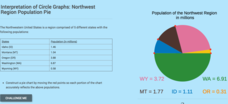
Interpretation of Circle Graphs: Northwest Region Population Pie
Given populations of the five Northwestern states, learners create a circle graph. Using the data and the pie chart, they make comparisons between the populations of the states. Finally, the pupils determine how the chart will change...


