DocsTeach
Lewis and Clark's Expedition to the Complex West
Lewis and Clark's famous expedition is a prime example of the United States' westward expansion. Aspiring historians examine maps from Lewis and Clark's journey, as well as discuss their interactions with Native American tribes. The...
CK-12 Foundation
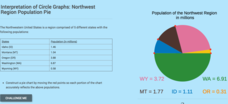
Interpretation of Circle Graphs: Northwest Region Population Pie
Given populations of the five Northwestern states, learners create a circle graph. Using the data and the pie chart, they make comparisons between the populations of the states. Finally, the pupils determine how the chart will change...
World Globes & Maps
United States Map- Intermediate Directions
Students identify the four intermediate directions. For this map skills lesson, students use post-it notes to label the four intermediate directions on a map. Students locate various states using intermediate directions.
Curated OER
A Five-Step Plan for the Ohio Country and the Northwest Territory
Students complete five worksheets which correspond to the five problems the American government faced and the five solutions they instituted, accompany this lesson. They select and research one of the steps in this plan and write a...
Curated OER
Mini Totems
Students create a totem pole in the vain of those made by tribes of British Columbia and Alaska.
Curated OER
Comparing Northwest Native American Communities
Students review how to use the database from previous lessons. Using the information, they identify the historical and environmental effects on the people living in the Pacific Northwest. They examine the various Native American groups...
Curated OER
The Three Faces of Isaac Stevens
Eighth graders examine three images of Isaac Stevens for information about the man and his activity as a US soldier, territorial governor and participant in treaty councils. Students are also shown Union Army pictures with different...


