Curated OER
Crossword: Afternoon on the Amazon
For this literature worksheet, students read 20 clues pertaining to the book Afternoon on the Amazon. Students fit their answers in a crossword puzzle. There is no word bank.
Curated OER
A Geography and Ecology Lesson for Grades 4-7
Pupils explore many of the unusual geographical features of the Amazon River region, and explain the importance of preserving the tropical rainforest.
Curated OER
Environment: Rivers of Destiny
Students investigate the results of human intervention with the Mekong. Mississippi, and Amazon rivers. After watching a video about the status of the three rivers, they complete experiments demonstrating the effects of erosion and...
Curated OER
Amazon Rainforest Unit
Students study the Amazon Rainforest. In this geography skills instructional activity, students complete assigned textbook reading on the region and then complete an Internet activity that requires them to identify countries in the...
Curated OER
Cane River Civil Rights: A Native American Perspective
Students interpret historical evidence presented in primary resources. In this civil rights lesson, students examine the civil rights struggle from a Native American perspective. Students analyze documents and write journal entries that...
Curated OER
Global History & Geography: Latin America
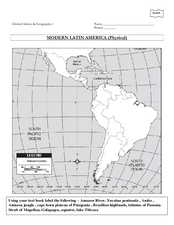
The instructions say to use a text-book to label 11 different regions in modern Latin America. If a text-book is not available a map can be found on-line and printed for student reference.
Curated OER
Regions of South America
Students explore facts about South America in the four lessons of this unit. Booklets are created from the materials produced as the class delves into the topic.
Curated OER
Amazon Rainforest: You Won't Find George in This Jungle
Students identify locations of rainforests, compare/contrast layers of the rainforest, construct and interpret maps and graphs, recognize relationships between man and the environment, and write about an imaginary walk in the rainforest.
Curated OER
How Do We Balance Environmental Conservation with Human Needs?
Learners role play a meeting between conservation biologists and local representatives who want to advance the livelihood of local population. In this history lesson, students research the necessities and conservation issues of given...
Curated OER
Vocab-u-lous! Build a Fabulous Vocab
In this vocabulary worksheet, students decipher the best word choice to complete the sentence. All words begin with the letter "E."
Curated OER
China's Three Gorges Dam
A very well-done resource includes an informational reading passage describing the controversy and impact of China's Three Gorges Dam. It also includes eight guided reading questions, a pros/cons arguments chart, and a creative writing...
Global Oneness Project
Bearing Witness
A controversial construction project in South America, the Belo Monte dam, is endangering local cultures, ecosystems, and communities. High schoolers create a concept map based on an online article they read before engaging in...
Curated OER
Central And South America And Their Ancient Civilizations
Fifth graders listen to lectures on the ancient civilizations of the Aztecs, Incas and Mayans. They construct a mask base and then decorate it in thirds with symbols meaningful to each of the three cultures being studied.
Curated OER
Electric Eels
In this electric eels worksheet, students read about the special muscle cells called electroplaques found in electric eels. Then students complete 3 short answer questions.
Curated OER
Unesco: Brazil: Central Amazon Conservation Complex
The Central Amazon Conservation Complex makes up the largest protected area in the Amazon Basin (over 6 million hectares) and is one of the planet’s richest regions in terms of biodiversity. It also includes an important sample of varzea...
Curated OER
Educational Technology Clearinghouse: Maps Etc: South America (Physical), 1901
A map from 1901 of South America showing the physical features of the region. This map is color-coded to show general elevations from sea level to over 6,500 feet, mountain systems, drainage divides, lakes, rivers, coastal features, and...
Curated OER
Educational Technology Clearinghouse: Maps Etc: South American Rainfall, 1901
A map from 1901 showing mean annual rainfall in South America. The map shows the equatorial rain belt in July and in January, the direction of prevailing winds and their effect on rainfall patterns. The map shows regions ranging from...
Curated OER
Educational Technology Clearinghouse: Maps Etc: Rainfall in South America, 1898
A map from 1898 showing mean annual rainfall in South America. The map shows the equatorial rain belt in July and in January, the direction of prevailing winds and their effect on rainfall patterns. The map shows regions ranging from...
Curated OER
Etc: Maps Etc: Orographical Map of South America, 1911
An orographic map of South America from 1911 showing the primary mountain systems and general elevations, and major river systems. The map is color-coded to show elevations from sea level to over 12000 feet, with highlands in buff tints...


