Curated OER
Landscape Diversity in the Yukon Territory
Students review and analyze a satellite image of the Yukon territory.
Curated OER
Organization of a Territory, Map Elements
Third graders compare printed and online maps and use proper geographic terminology to answer questions.
Curated OER
Mapping the Halifax Explosion
Students research the Halifax Explosion using historical maps.
Curated OER
Sarah, Plain and Tall Study Guide
Patricia MacLachlan’s award-winning novel, Sarah, Plain and Tall, is the focus of a comprehensive study guide. For each chapter, readers answer fact-based and interpretative questions, define and use vocabulary words in a sentence, and...
Curated OER
Social Studies: Canadian City Comparison
Learners research Canadian population distribution while comparing and contrasting the quality of life in two cities. They discuss issues and problems that cities and rural towns face. Students apply various methods, such as graphs and...
Curated OER
First You Take an Ecumene
Although this was written regarding Canadian agriculture, it can be used in any agriculture or environmental science class. Learners evaluate agricultural and economic activity maps and consider land use competition. Activities that get...
Curated OER
A Feature Presentation - Geographic Landforms
Students investigate, identify and compare the various geographic terms that can be used to describe the landforms occurring in the Hawaiian islands.
Curated OER
Fourth Grade Social Studies
For this social studies worksheet, 4th graders answer multiple choice questions about George Washington, early America, natural resources, and more. Students complete 8 questions.
Curated OER
Going into the Great North
Students observe and investigate the areas included in the Great North. In this geography lesson, students observe a documentary based on the Great North. Later the students will draw and identify countries within the arctic circle and...
Curated OER
Teaching About the Hydrosphere
Eighth graders are introduced to the Earth's hydrologic system including the cycling of water in the atmosphere and the movement of water on the surface of the planet using the Great Lakes watershed as an example.
Curated OER
Investigating Latitude and Longitude
Students examine the lines of latitude and longitude on a map, and explain why these lines might be useful. In this lesson students also explore websites that provide information to improve their understanding of how and why latitude and...
Curated OER
We've got the whole world in our hands
Students explore spatial sense in regards to maps about the globe. In this maps lesson plan, students label oceans, locate the continents and poles, follow directions, and explain the symbols on a map.
Curated OER
Polar Day: Comparing My Community to a Northern Community
Third graders practice their geography skills. In this Polar Day-themed lesson plan, 3rd graders use their research skills to compare and contrast the place, regions, and human systems in their community to a Canadian northern polar...
Curated OER
Arctic cleanup
Ninth graders examine pollution problems and how it affects the community. In this arctic cleanup lesson students study ocean currents and how they affect pollution.
Curated OER
State to State Scavenger Hunt
In this states worksheet, students utilize the Internet to access one specific website to locate the answers to five fill in the blank statements about the states found on a United States map.
Curated OER
KNUD RASMUSSEN – "THE OLD AND THE NEW"
Students consider Inuit culture and point of view. In this Native land encroachment lesson, students read "The Old and the New" to examine the position of the Inuit tribe on the establishing of trading posts in the Arctic.
Curated OER
Currently Warm
Seventh graders investigate how ocean currents affect climate. In this earth science lesson, 7th graders draw and label the current in their assigned ocean. They discuss how currents from the poles differ from the equator.
Curated OER
Fugitive Slave Narratives
Middle schoolers analyze the ways slavery shaped social and economic life in the South after 1800, the different economic, cultural, and social characteristics of slavery after 1800, and the ending of the Atlantic slave trade.
Curated OER
An Introduction to Shamanism
Students investigate Inuit customs. In this cultural traditions lesson, students read about religious customs of the Inuit including Shamanism. Students discuss the role of Shaman and create Inuktitut-English dictionaries with terms...
Curated OER
Literary Element : Setting
In this language arts worksheet, students focus on story setting. Using the graphic organizer provided, students fill in the time, place, and backdrop of the given story.
Curated OER
Alaska the Elephant
Students explore an Internet website, locating and matching the shape of an elephant's head to a state in the U.S. They complete an Alaska worksheet, identifying other geographical locations surrounding Alaska.
Curated OER
Great North
Young scholars use maps to locate the Arctic Circle, the North Pole and Northern Europe. They draw and label countries within the Arctic Cirlce and identify the groups of people who live there. They also watch and answer questions about...
Houghton Mifflin Harcourt
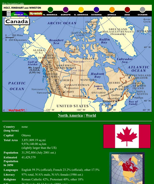
Holt, Rinehart and Winston: World Atlas: Canada
A detailed map showing the provinces and territories of Canada. You can enlarge the details by clicking on any area or name on the map.
World Atlas
World Atlas: Canada
A comprehensive website on Canada. Includes colored maps, geographic information, and articles. Click on any tab above the maps to find much more information on topics such as famous Canadians, flags, symbols, travel, weather, and lots...


