Corbett Maths
Enlargements with Fractional Scale Factors
Enlargements make it bigger, right? A video shows viewers how to perform a basic dilation with a fractional scale factor. They learn how to use the scale factor to find the location of the transformed vertex by multiplying the horizontal...
Curated OER
TE Activity: Nidy-Gridy
Students make a grid and coordinate system map of their classroom as they investigate why it is important to have a common map making system. They look at how landmarks are used for navigating an area.
Curated OER
The Next Dimension
Students explore the three dimensional Cartesian coordinate system and discuss how it is important for structural engineers in order to be able to describe locations in space to fellow engineers. They participate in a hands-on activity...
Mathematics Assessment Project
Aaron's Designs
Learners first create designs for greeting cards by applying transformations of shapes on a coordinate plane, and then determine a sequence of transformations that produces a given design.
Curated OER
Where is it?
Students use a coordinate grid. They investigate and discuss what caused certain objects to be in specific places. They choose a room in their home to map and place objects in specific locations.
EngageNY
The Geometric Effect of Some Complex Arithmetic 1
Translating complex numbers is as simple as adding 1, 2, 3. In the ninth lesson in a 32-part series, the class takes a deeper look at the geometric effect of adding and subtracting complex numbers. The resource leads pupils into what it...
CPM
Rigid Transformations
In this rigid transformation worksheet, students follow directions to translate, reflect or rotate a figure in a coordinate plane. Examples and explanations are provided at the beginning of the document. This two-page worksheet contains...
Mathematics Vision Project
Circles: A Geometric Perspective
Circles are the foundation of many geometric concepts and extensions - a point that is thoroughly driven home in this extensive unit. Fundamental properties of circles are investigated (including sector area, angle measure, and...
Curated OER
Mapping Natural Disasters
Students use Cartesian coordinates to plot current natural disasters. They relate location of natural disasters to their specific major project countries. Students tie in geometry within this lesson as connected to spatial relationships...
Space Awareness
Valleys Deep and Mountains High
Sometimes the best view is from the farthest distance. Satellite imaging makes it possible to create altitude maps from far above the earth. A three-part activity has your young scientists play the role of the satellite and then use...
Radford University
Finding a Location for Your Kitchen Island
Where is the best place to work? Small groups map out a kitchen on a coordinate plane and find the centers of the work triangle to find the best place to install an island. The teams use algebraic methods to locate the center by finding...
Curated OER
Distance Formula
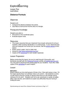
Students create ways to find the number of square miles that lie in a triangle having vertices at A, B, and C. They compute the distance between two points and use Heron's formula to find the area of the triangle. Finally, students...
Curated OER
Relations
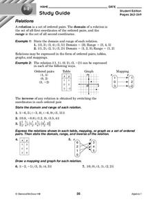
In this relations activity, 10th graders solve and complete 7 different problems that include defining various relations of number sets. First, they state the domain and range of each relation. Then, students express the relations shown...
Curated OER
Trigonometry: Worksheet for Test #4
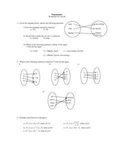
In this trigonometry worksheet, students determine whether given mappings are functions. They evaluate 5 functions for a given x value. Students graph 2 functions. They determine which ordered pairs are solutions to given functions....
Curated OER
Relations
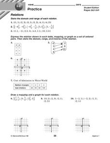
In this relations instructional activity, 10th graders solve and complete 10 different problems that include defining various forms of relations. First, they state the domain and range of each relation. Then, students express the...
Curated OER
What a Site!
Fourth graders are introduced to how to properly create a grid site. In groups, they use Cartesian coordinates to establish the boundaries for the grid and photograph the location of artifacts. They exchange their photos with another...
Curated OER
Three D Constellations
Students are introduced to both celestial coordinates and to the first rung on the distance determination ladder. They convert spherical coordinates to Cartesian coordinates to construct a three dimensional model of a constellation...
Curated OER
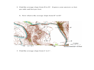
Slope and Topographic Maps
Students investigate slopes as they study topographic maps. In this algebra activity, students discuss and apply the concept of slopes to graphing and analyzing data.
Curated OER
Cookie Mapping
Students study the components of a bedrock geology map through a hands-on activity involving a cookie and graph paper.
Curated OER
Where in the Latitude Are You? A Longitude Here.
Students distinguish between latitude and longitude on the map. In this mapping lesson, students participate in mapping skills to recognize spatial relationships, and where to find natural resources on the map. Students create...
Curated OER
A Message in a Bottle
Students investigate the motion of water currents by mapping the possible movement of messages cast into the ocean in bottles.They accurately plot the appearance of bottles on a world map and illustrate the flow of an ocean current...
Curated OER
Quiz: Translations and Vectors
In this translation and vector activity, learners graph and label translations of polygons and points. Translation instructions are given as ordered pairs, as well as in written words. This one-page activity contains ten problems.
Mathematics Assessment Project
Square
Don't be a square! Young mathematicians determine the slope and length of a line segment. They then prove whether four given coordinate points form a square.
101 Questions
Transforming Houses
Moving a house is hard work. Given a diagram of a row of houses, scholars determine a set of transformations that would map one house to the next. A second diagram with a coordinate plane helps with the task.


