Curated OER
States & Capitals 1-25
Young pupils test their geography skills by matching the 50 states to their correct state capitals. The states are listed in alphabetical order on the left, and a list of state capitals are presented in random order in a right-hand...
Curated OER
United States Geography: Crossword Puzzle
In this geography worksheet, middle schoolers use the 14 clues in order to fill in the crossword puzzle with the appropriate United States geography answers.
Curated OER
States in the USA Quiz
In this online interactive geography quiz worksheet, students respond to 50 identification questions about the states in the United States of America. Students have 4 minutes to complete the quiz.
Curated OER
Florida State Map
In this geography of Florida worksheet, students color the map and label major cities and physical features. Students also study a second map showing the location of the state of Florida in the United States.
Curated OER
Dos mapas de Florida, el Caribe y parte de Sur America
What can maps tell us about the past? Find out with a Spanish lesson that incorporates geography. After examining maps individually, comparing two old maps of Spanish Florida and writing notes in the provided Venn diagram, pupils pair up...
Curated OER
Straberry Girl: Florida's Location and Shape
Students explore geography by reading a story about Florida. In this Florida vegetation lesson, students read the book Strawberry Girl and identify the locations in Florida that are mentioned in the book. Students identify the type of...
Curated OER
What They Left Behind: Early Multi-National Influences in the United States
Students examine how the European voyages of discovery influence American culture even today. They map eighteenth century Europe's impact on the United States.
Curated OER
Florida: U.S. Geography for Kids
In this Florida geography activity, students locate and label the important features of Florida and create icons for the economy and culture of Florida.
Curated OER
US Geography Crossword
In this 50 states instructional activity, students complete a crossword puzzle with facts about US geography. There are 22 words to fit in the puzzle, which has no word bank.
Curated OER
What They Left Behind: Early Multi-National Influences in the United States
Students research the impact of European voyages of discovery and colonial influence on different aspects of American culture. They access a number of online sources and reference maps to trace the influences of England, France, Holland,...
Curated OER
A Tough Nut to Crack
Sixth graders explore agriculture by examining world geography. For this pecan cultivation lesson, 6th graders identify the history of the famous nut and the impact it has on the U.S. economy, diet and human body. Students define...
Curated OER
A Look at the Population Density of the United States
Young scholars acquire census information and create maps of the population density of the United States on different scales. They role play the roles of workers of a retail company and they use the population data to market to their...
Curated OER
Exploring Florida
Students explore the state of Florida. They study the basic facts associated with the state, such as : the capital, the state bird, and the state song. They locate places in Florida and about the climate, tourism, and agriculture.
Curated OER
State to State Scavenger Hunt
In this states worksheet, students utilize the Internet to access one specific website to locate the answers to five fill in the blank statements about the states found on a United States map.
Curated OER
Maps
Maps, globes, and computer software aid young explorers as they locate state capitols, major cities, geographic features, and attractions for states they are researching. They then use desktop publishing software to create a map to share...
Curated OER
5th grade social studies geography
In this geography worksheet, 5th graders complete multiple choice questions about hemispheres, maps, cities, ecology, and more. Students complete 25 questions.
Curated OER
Big Arky, A Real Arkansas Monster
Middle schoolers examine the world of the Arkansas alligator and topics that are related to wetland environments. They pay attention to the relationship between geography, climate, environment, and the animals who live there. A role-play...
Curated OER
Introduction to the United States Map
Students identify the United States of America and it's states on a map. In this mapping instructional activity, students examine a globe and find the United States as well as a few land marks (Florida and the Great Lakes). Students...
Curated OER
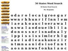
50 States Word Search
In this fifty states activity, students identify and locate all fifty states of the United States of America. There are 50 states located in the word search.
Curated OER
Florida the Best WebQuest
Students create a multimedia presentation demonstrating that Florida is the Best State in this creative project for the early elementary classroom. The lesson can be adapted for any state or country.
Curated OER
Scrambled States
Students read or are read the story "Scrambled States". Using a map, they identify their states and time zones. They predict their states representation in the book and discuss it after the book is finished. They discvor the differences...
Curated OER
Our State Road Trip
Learners take a virtual tour of the country of China instead of a state. Using the Internet, they examine the differences between a political and physical map and use latitude and longitude to locate specific places. They also research...
Concord Consortium
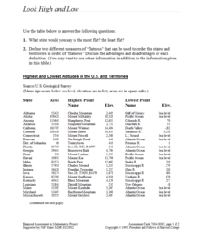
Look High and Low
From the highest high to the lowest low here's a resource that won't fall flat. Given data on the area and the highest and lowest elevations of each of the 50 states, learners decide which states are the least flat and the most flat. Of...


