Curated OER
Math with Maps and Globes
Students round out their math skills with these ‘round the world' ideas. In this math and geography lesson, students try out time zone sticks, a polar race, and tic-tac-globe to engage them in learning more about globes and the...
Curated OER
The Crash Scene
Fifth graders explore geography by participating in a mapping activity. In this engineering lesson, 5th graders identify the differences between latitude and longitude and practice locating precise points on a globe or map. Students...
Curated OER
The Expansion of Islam to 750
Track the expansion of Islam throughout the Mediterranean and Near East. Locate and label 17 different areas that adopted the tenets of Islam.
Curated OER
Grocery Store Field Study
Students visit a local grocery store (not a community market) to gather information about where some commonly eaten produce items come from. Once they have collected this information, locate the countries of origin on a map and research...
MENSA Education & Research Foundation
Connecting Africa: A Project-Based Learning Adventure
Mission Possible: Your task is to design a new highway route from Tunis, Tunisia to Cape Town, South Africa. If you accept the challenge, you must create a small map of the route that has already been rejected, a...
Curated OER
The Zabbaleen, Cairo's Garbage Workers
Here is a fascinating human geography study of the Zabbaleen. They are a sub-class of people who work as garbage collectors in Cairo, Egypt. I can't say enough good things about this resource in my limited space here. It is fabulous! If...
Global Oneness Project
A Collapsing City Skyline
Have your high schoolers learn about the modern history of Myanmar by close-reading an article about the city and people of the city Yangon. As they'll learn, the country is going through some dramatic transitions. After...
Curated OER
WORLD GEOGRAPHY
Students identify and analyze map symbols and map grids by completing various worksheets and creating their own map using these skills. Students identify and analyze what latitude and longitude are on a map to play a game of Bingo....
Curated OER
Kid Maps: Reading and Creating Maps with Human Characteristics
Students look at maps. In this map lesson, students listen to the book My Map Book by Sara Fanelli and they see the difference between human characteristics (buildings, etc.) and natural characteristics (rivers, etc.). They...
Curated OER
BOLTSS Map
In this geography worksheet, students identify the six features always used on maps. They identify each of these features by the acronym BOLTSS. Students examine the Melbourne Cricket Ground shown and respond to the 4 questions that follow.
Curated OER
Geography - Mapping the Holocaust
Eighth graders map the important locations of the Holocaust. In this Holocaust lesson, 8th graders research the location of countries involved in the Holocaust as well as the location of concentration camps. Students mark the locations...
Curated OER
Map Facts Worksheet
In this geography, ecology, and folklife worksheet, students search Louisiana maps of their choosing to discover the factual information required to complete the graphic organizer.
Curated OER
Geographical Skills-- Map Scale
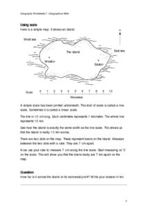
In this maps worksheet, students study a simple map and the scale in kilometres. Students read the directions and answer one question. Students then look at a sketch map of a town and answer 2 questions. Students also read how to show...
Curated OER
Tasty Mapping
Students create an edible map. In this civics and geography lesson, students research their town's features and local government. Students work in groups to design and create a physical map of their town based on research.
Curated OER
Map Projections
Young scholars view examples of various map projections using a website. Students record differences between the map projections. Young scholars discuss uses for the various map projections and the differences between the maps they...
Curated OER
Arkansas Geography/History Relief Map
Sixth graders research a number of sources including the Internet to find information about the regions of Arkansas while locating sites of national historic interest. They located sites on maps while working at assigned websites. They...
Curated OER
Thinking Critically about Geography
In this map reading worksheet, students answer 2 critical thinking questions about a map shown. Page has links to additional resources.
Curated OER
Geography/Current Events Project
Using the Balkan region as an example, fourth graders review the five themes of geography as a class. They identify the physical and human characteristics of a region before labeling the countries and landforms on a map. They then...
Curated OER
Across the United States- Home Learning Activity
In this home-school United States map activity, learners work with a family partner as they study a map of the United States. They talk about the states they have visited, play a game by giving each other clues about states, and write...
Curated OER
A world of oil
Students practice in analyzing spatial data in maps and graphic presentations while studying the distribution of fossil fuel resources. They study, analyze, and map the distribution of fossil fuels on blank maps. Students discuss gas...
Curated OER
Geo-Magazine
Divide your geography class into groups and have each research an assigned region. The result of this project is a regional magazine that addresses the five themes of geography. Many valuable resource links are embedded into the...
Sharp School
Travel Brochure Project
Designing a travel brochure is a classic project that will help your class members develop a variety of skills, such as researching informational texts, designing creative visual products, and communicating what you have learned.
Curated OER
World Projections
Students identify map projections and examine polar maps. In this map skills lesson plan, students use a flat world map to identify various projections and calculate the distances between locations by using a map scale.
Curated OER
Learning About Maps
Students investigate the many uses and features of maps and globes and locate where they live on both. In this map lesson plan, student play a travel game and create their own maps to explore states, continents, countries, and islands.
Other popular searches
- Geography Map Skills Scale
- Geography Map Skills Europe
- Usa Geography Map Skills
- Geography Map Skills Us
- Canada Geography Map Skills
- Map Skills Geography Themes
- Geography Map Skills Ohio
- Map Skills Geography


