Richmond Community Schools
Map Skills
Young geographers will need to use a variety of map skills to complete the tasks required on this worksheet. Examples of activities include using references to label a map of Mexico, identify Canadian territories and European countries,...
Curated OER
Map Skills
Thirds graders reinforce that a map is a drawing that shows what a place looks like from above. They use a map key and symbols to create a map of the school and its neighborhood.
Ed Helper Clip Art
USA States
Looking for a map of the Unites States of America? Look no further than this printable map designed to accompany your geography instruction and to give map skills a boost.
Mr. Printables
Map of The USA Jigsaw Puzzle
Encourage young learners to explore the United States with this printable map puzzle. A fun activity that engages children in learning US geography.
Curated OER
Food on the Map
Learners work together to examine the tastiest towns in the United States. After discovering the names of the equipment, they identify the seven continents. They take a survey and locate the cities and states of the foods mentioned.
Curated OER
Exploring the USA and the World with Cartograms
Middle schoolers investigate cartograms in order to explore the different countries on Earth. In this world geography activity, students use the Internet to analyze data on different cartograms. Middle schoolers compare data, such as...
Curated OER
Names and Places
Students explore where jobs are done. In this careers and geography lesson, students locate places in Canada on a map and list jobs that are done in their area of Canada. Lesson includes extension and differentiation ideas.
Curated OER
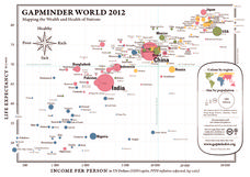
Gapminder World 2012
Here is a very interesting infographic that compares the average life expectancies, per capita incomes, and population sizes of every country in the world in 2012.
Curated OER
Geography and World History
Students build off of their current knowledge of geography and world history, while being introduced to new concepts and ideas.
Curated OER
Muppet Treasure Island
Students watch the movie "Muppet Treasure Island" and then taking on roles of characters in the movie answer navigational questions to try discover the location of a treasure hidden by the teacher.
Curated OER
Projects For USA Units
Students study different regions of the United states through interdisciplinary activities. This lesson presents very creative, artistic ways for students to explore the variety of regions found in the United States.
Curated OER
States in the USA Quiz
In this online interactive geography quiz worksheet, students respond to 50 identification questions about the states in the United States of America. Students have 4 minutes to complete the quiz.
Curated OER
Edible Resource Maps
Third graders work in groups to create an edible resource map showing locations of at least five resources in the United States. Students research on the internet different regions and the resources that are found in those areas. They...
Curated OER
Temperature and Daily Life: Mexico City and Indianapolis
Students compare the effect of temperature on daily life of a citizen in Mexico City, Mexico with that of a citizen of Indianapolis, Indiana.
Curated OER
USA National Parks Quiz
In this online interactive geography quiz worksheet, learners examine the chart that includes 58 state names. Students identify the names of the national parks in the listed states in 5 minutes.
Curated OER
Tracking Satellites Using Latitude and Longitude
Students, viewing an Internet site, plot the path of several satellites using latitude and longitude over the course of an hour. They learn the four basic types of satellites and their purpose.
Curated OER
Freeform Pennsylvania Map
In this Pennsylvania map worksheet, students research, study and label twenty important cities, physical attributes and the neighbors that surround Pennsylvania on a Pennsylvania map.
Curated OER
Introduction to the United States Map
Students identify the United States of America and it's states on a map. In this mapping activity, students examine a globe and find the United States as well as a few land marks (Florida and the Great Lakes). Students then look at a...
Curated OER
United States Map Quiz
In this online interactive geography quiz worksheet, learners respond to 50 identification questions about the shapes of countries shown. Students have 5 minutes to complete the quiz.
Curated OER
Reading a Local and National Weather Map
Students practice reading a national and local weather map. Using this information, they work together to make predictions about the weather for the next few days. They discuss the use of symbols and maps as a class and discuss how...
Curated OER
Daily Life in Ancient Greece
Sixth graders discover what everyday life was like for Ancient Greeks. In this Greek history instructional activity, 6th graders examine the cultural diversity of Ancient Greece and how it affected daily life for its citizens.
Curated OER
Mesopotamia
Students map Mesopotamia. In this Geography lesson, students are introduced to Ancient Mesopotamia. Students use an atlas to label the defining features and areas of Mesopotamia on a map.
Curated OER
Five Themes of Geography and Current Events
Basically, pupils look for a current world event from a reputable source and identify the five themes of geography within it. Throughout the school year, they keep a notebook of these current events. A grading guideline is outlined, and...
Curated OER
Biggest Metro Areas in the USA
In this online interactive geography quiz worksheet, students respond to 100 identification questions about metropolitan areas in the United States. Students have 10 minutes to complete the quiz.


