Curated OER
U.S. History: What Happened Here?
Students apply the global positioning system to create maps of local historical sites. By collaborating with local historical groups, they research events and relate them to broader, national history. In addition to writing essays...
Curated OER
Study of New York City
Fourth graders read A Cricket in Times Square and examine the essence of living in New York City. They examine subway maps and other resources concerning NYC and then complete several writing activities about the city. They also create...
Curated OER
Geography Game
Second graders, in groups, selects a letter as a starting point and announces the direction in which he intends to move on a map. The team that closes a square takes possession of the square and marks it with their symbol.
Curated OER
Peru Geography and the Environment
Fourth graders draw maps of Peru and examine how Peru is a geographically diverse country.
Curated OER
On the Street Where You Live: Online Mapping
Students access the Internet and use Google Maps to pinpoint their home address and get directions to and from school. they write the directions in paragraph format.
Curated OER
U.S. geography for Children: New York
In this geography activity, 5th graders study the state of New York. Students follow the given directions to complete 5 tasks on the state map that is given.
Curated OER
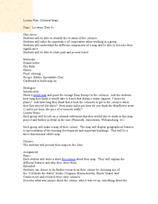
Colonial Maps
Students discover the history of America by identifying the traditional colonies. In this U.S. history lesson plan, students examine a world map and identify where the voyagers left from Europe to arrive at the United States. Students...
Curated OER
Canada Geography PowerPoint
Students create a PowerPoint about Canadian geography or history. In this Canada lesson, students spend two days researching their Canadian topic in the library and online. They create a PowerPoint presentation and add pictures taken...
Curated OER
Reading a Local and National Weather Map
Students practice reading a national and local weather map. Using this information, they work together to make predictions about the weather for the next few days. They discuss the use of symbols and maps as a class and discuss how...
Curated OER
Geography of Japan
Students complete a worksheet that guides them through an overview of Japanese geography. Students research the topography, climate, population and size of Japan and consider how these factors work together to produce Japanese culture.
Curated OER
What in the World?
Eighth graders plot points of longitude and latitude on a world map. In groups, they create a model of the earth's interior and label the parts,
Curated OER
Journey to Japan: An Elementary Geography Standards-Based Unit on Japan
Second graders compare and contrast Japanese customs and culture to those of Americans through research in this year long study. They determine the basic needs of all people in spite of cultural differences.
Curated OER
North America
In this map of North America worksheet, students study the map of North America and then write the names of the 11 countries on the provided lines.
Curated OER
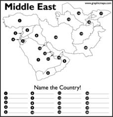
Middle East
In this map of the Middle East worksheet, students study the map of the Middle East and then write the names of the 20 countries on the provided lines.
Curated OER
Turkey: Bridge Between East and West
Ninth graders study the geography of Turkey. In this Geography lesson, 9th graders examine the characteristics of Turkey. Students create an annotated map of Turkey.
Curated OER
Studying the States!!!
Students explore the fifty states of America. They also learn the capitals and locations of the states. They also study the population, mottos, flags, and interesting historical facts about each state.
Curated OER
How Can We Organize Study of a Given Place?
Seventh graders embark in discovery of basic facts about an assigned continent and are asked to organize their information into categories. The Five Themes model is taught and students reshuffle their information appropriately.
Curated OER
Taming the Mighty Dragon
Learners incorporate the five themes of geography to study the Yangtze river region. They analyze the possible effects of the three rivers gorge damn project on this area and role play a float the entire length of this dangerous river...
Curated OER
Diversity Geography
Ninth graders explore the diversity of people found throughout the world. In this Geography lesson plan, 9th graders create a short oral report describing that area.
Curated OER
Do You Need a Map?
Students explain ways marine navigation is important in modern society. In this map study lesson students use a retrieval tool to obtain real-time information on weather forecasts.
Curated OER
The Geography of Renaissance
Students use the internet to research the geography of the Renaissance. Using maps of Europe, they identify at least three key cities during the time period and discuss the main types of transportation. They research the various customs...
Curated OER
Geography: Why Is the Sacremento Valley a Good Place to Grow Rice?
Third graders locate the Sacramento Valley in California where rice is grown. In this rice growing location lesson, 3rd graders locate the Sacremento Valley, California on a map, and color the mountain ranges and terrain that is around...
Curated OER
Australia
In this map of Australia worksheet, learners research and study a map of Australia. Students label Australia's regions, major states and important landmarks.
Curated OER
Water and Land 207
Students examine maps of different projections, mathematically calculate distortions, and note the advantages and disadvantages of each map. They study the different maps and transfer the map to graph paper.
Other popular searches
- Geography Map Skills Scale
- Geography Map Skills Europe
- Usa Geography Map Skills
- Geography Map Skills Us
- Canada Geography Map Skills
- Map Skills Geography Themes
- Geography Map Skills Ohio
- Map Skills Geography


