Curated OER
Mapping Mistakes
Students examine early European maps and explore geographic errors. They also view maps of the geography of North America. Students discuss the obstacles faced by early explorers in mapping unexplored territory. They consider what the...
National Geographic
Mapping the Americas
Celebrate the geography of the Americas and develop map skills through a series of activities focused on the Western Hemisphere. Learners study everything from earthquakes and volcanoes of the Americas and the relationship...
Curated OER
The United States and Canada
While just a short review of some simple facts about the United States and Canada, this could be a useful resource for an introduction to North America. Teachers could use this as a model for student projects or could add more...
Curated OER
North America Outline Map
In this blank North America outline map learning exercise, students study the political boundaries of the continent. This outline map may be used for a variety of geographic activities.
Curated OER
Tour Of South America
Students explore South America. For this geography lesson, students research landmarks of historical or national significance and use their findings to create slideshows.
The New York Times
Decision Point: Understanding the U.S.’s Dilemma Over North Korea
Simulate the Situation Room and analyze the US's relationship with North Korea. The plan starts off with a quick review and an examination of a online timeline that updates as the situation continues. Next, the class reads an article and...
Curated OER
North America Map Quiz
In this online interactive geography quiz learning exercise, students respond to 19 identification questions about the countries located in North America.
Curated OER
Major Lakes of North America
In this North American learning exercise, students explore the locations of the major lakes on the continent. The map may be used for a variety of geography lessons.
Curated OER
Welcome to the Americas
Students research and map the North and South American continents. In this geography lesson on the Americas, students can locate North, Central and South American countries and states. Students choose a location to research and prepare a...
Curated OER
North America
For this map of North America worksheet, students study the map of North America and then write the names of the 11 countries on the provided lines.
Curated OER
The Geography of the United States
Full of bright maps and interesting information, this presentation details U.S. Geography. Slides include basic facts about size, regions, topography, and demographics, as well as fascinating trivia about the United States, including...
Curated OER
The Mystery of Exploration
Students comprehend the history of European exploration of North America. They are introduced to basic reasearch techniques. Students focus on four explorers who visited New York State: Verrazano, Cartier, Champlian, and Hudson. They...
Curated OER
North America Capitals Map Quiz
In this online interactive geography quiz worksheet, students respond to 16 identification questions regarding capital cities of North American countries.
Curated OER
Colonial America and Roots of Government
Students identify 50 States and the major geographic features, regions, and political representation of each. In connection, they investigate the causes and effects of European colonization on North America. They identify the formation...
Curated OER
North American Rivers Map Quiz
In this online interactive geography quiz learning exercise, students examine the map that includes 13 rivers in North America. Students match the names of the rivers to the appropriate places on the map.
Curated OER
Geography Words, Page 1
In this geography words and maps worksheet, students examine maps of North and South America. Students respond to 12 multiple choice questions regarding the maps.
Devine Educational Consultancy Services
Geography Student Workbook, Australia
Your youngsters will be experts on the geography of Australia after working with these activities and worksheets, which review the continent's weather, major landforms, dimensions, history, and climate.
Curated OER
Americas: Political Map
In this North America and South America outline map worksheet, students examine the political boundaries of the 2 continents.
PBS
Make a Balloon Globe
"We've got the whole world in our hands," is what your students will be singing after completing this fun geography activity. Using the included templates for the seven continents and a balloon, they create their very own globes.
World Maps Online
Introduction to the World Map
Students identify the differences between maps and globes. In this map skills instructional activity, students are shown a globe and a map and recognize the differences. Students use post-it notes to locate several locations on the world...
Curated OER
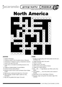
North America Puzzle
For this geography worksheet, students complete a crossword puzzle in reference to North America. They identify capitals of some countries, the specific landforms of different areas, and languages spoken. There are 21 clues to solving...
Curated OER
North America Puzzle Answer Sheet
In this geography learning exercise, students name the capitals of various countries found in North America. They also identify the various weather patterns across the continent and specific bodies of water. There are 21 descriptions and...
Curated OER
Pre-Columbian Cultures in the Americas
Native American studies is fun, educational, and highly motivating. Fifth graders will gain a deeper understanding of the six major pre-Columbian culture areas on the North American continent. They will choose one group and conduct...
National Park Service
News Bearly Fit to Print
There are an average of three human fatalities by bears in North America every year, which is low when you compare it to the 26 killed by dogs and the 90 killed by lightning annually. The lesson encourages researching human-bear...
Other popular searches
- North America Geography
- North American Geography
- North America World Geography
- Geography North America Maps


