Other
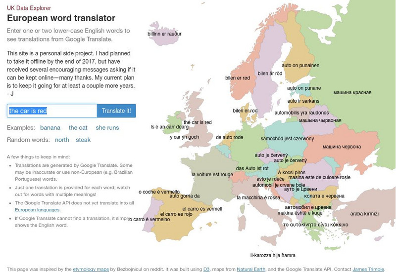
Uk Data Explorer: European Word Translator
Enter one or two lower-case English words to see translations from Google Translate. The translations are superimposed onto the related countries in a map of Europe.
Other
Critical Thinking Works: Investigating the Inca
Students can explore Peruvian culture through project-based learning. In the role of present-day reporters, students will research the lives of the Inca in the 15th and 16th centuries. Includes suggestions for actively engaging students,...
Stanford University
Stanford University Library: Hart Project
Explore the collection of 364 photographs which are plotted within this 3-D map experience recreating Alfred A. Hart's journey along the Central Pacific Railroad. The goal of his 1860s expedition was to solicit investment in the...
Other
Bscs: Frog Eat Frog World
In this self-directed instructional activity, students will use maps and Frogwatch data to explore the natural and invasive range of the American bullfrog. A handout with everything the student needs to complete this instructional...
Other
Bscs: Budburst Lilac Festival
In this self-directed activity, students use graphs and maps of lilac phenology data to determine the best time to host a lilac blossom festival in their area. A handout with everything the student needs to complete this lesson is...
Other
Bscs: Asking and Answering Questions With Data
In this self-directed lesson, students use graphs and maps of water quality to investigate relationships between variables to answer questions. A handout with everything the student needs to complete this lesson is available as a PDF or...
Curated OER
Madagascar Satellite Photo
Check out this great satellite image of Madagascar from Google Earth. Scroll past the informative political map to see the image. There is more information about the country below the satellite map.
TES Global
Blendspace: At Resources
This eleven-part learning module provides assorted assistive technology references. This blendspace provides reading and writing video, print, and audio resources that will help special needs students with their reading and writing.
US Geological Survey
Usgs: Edna Derived Watersheds for Major Named Rivers
A watershed index where students can click on a map of the U.S. to find the names and locations of watersheds. Students can also download a file that can be run in Google Earth to view more about the watershed.
Curated OER
Kazakhstan Satellite Photo
Check out this great satellite image of Kazakhstan from Google Earth. Scroll past the informative political map to see the image. There is more information about the country below the satellite map.
Curated OER
Kyrgyzstan Satellite Photo
Check out this great satellite image of Kyrgyzstan from Google Earth. Scroll past the informative political map to see the image. There is more information about the country below the satellite map.
Curated OER
China Satellite Photo
Check out this great satellite image of China from Google Earth. Scroll past the informative political map to see the image. There is more information about the country below the satellite map.
Curated OER
Kuwait Satellite Photo
Check out this great satellite image of Kuwait from Google Earth. Scroll past the informative political map to see the image. There is more information about the country below the satellite map.
Curated OER
Albania Satellite Photo
Check out this great satellite image of Albania from Google Earth. Scroll past the informative political map to see the image. There is more information about the country below the satellite map.
Curated OER
Angola Satellite Photo
Check out this great satellite image of Angola from Google Earth. Scroll past the informative political map to see the image. There is more information about the country below the satellite map.
Curated OER
Botswana Satellite Photo
Check out this great satellite image of Botswana from Google Earth. Scroll past the informative political map to see the image. There is more information about the country below the satellite map.
Curated OER
Lesotho Satellite Photo
Check out this great satellite image of Lesotho from Google Earth. Scroll past the informative political map to see the image. There is more information about the country below the satellite map.
Curated OER
Malawi Satellite Photo
Check out this great satellite image of Malawi from Google Earth. Scroll past the informative political map to see the image. There is more information about the country below the satellite map.
Curated OER
Namibia Satellite Photo
Check out this great satellite image of Namibia from Google Earth. Scroll past the informative political map to see the image. There is more information about the country below the satellite map.
Curated OER
Swaziland Satellite Photo
Check out this great satellite image of Swaziland from Google Earth. Scroll past the informative political map to see the image. There is more information about the country below the satellite map.
Curated OER
Zambia Satellite Photo
Check out this great satellite image of Zambia from Google Earth. Scroll past the informative political map to see the image. There is more information about the country below the satellite map.
Curated OER
Cameroon Satellite Photo
Check out this great satellite image of Cameroon from Google Earth. Scroll past the informative political map to see the image. There is more information about the country below the satellite map.
Curated OER
Equatorial Guinea Satellite Photo
Check out this great satellite image of Equatorial Guinea from Google Earth. Scroll past the informative political map to see the image. There is more information about the country below the satellite map.
Curated OER
Gabon Satellite Photo
Check out this great satellite image of Gabon from Google Earth. Scroll past the informative political map to see the image. There is more information about the country below the satellite map.
Other popular searches
- Scale Factor Google Maps
- Geography Google Maps
- Venn Diagram Google Maps
- Google Maps Science
- Google Maps 13 Colonies


