Curated OER
Sea Floor Spreading II
Students import ocean bathymetry data from text files. They then graph these observations along with model predictions to assess the model's ability to simulate observed topographic features of the North Atlantic. Students use Excel to...
Curated OER
Scavenger Hunt
Young scholars study a research telescope to obtain quantitative information about these objects. They use the SkyServer Navigation Tool to identify objects and record celestial coordinates. In addition, they associate star brightness...
Curated OER
Mongolia Geography
Young scholars examine the geography and culture of Mongolia. Individually, they cut out cut-outs of animals to place on their maps and label the grasslands and desert areas. They locate major cities and rivers along with vegetation.
Curated OER
Subsidence/ Erosion
Students utilize prior knowledge about the Pontchartrain Basin. In this subsidence/erosion lesson, students study the chart on land subsidence and must them identify and find solution for problems caused by erosion.
Curated OER
The Slave Trade
Students map and explore a possible slave trade route. In this slave trade mapping lesson plan, students calculate the distance and amount of time it would take for African slaves to arrive in America.
wikiHow
Wiki How: How to Get Longitude and Latitude From Google Maps
This article will teach you how to get longitude and latitude for any given location using Google Maps.
Other
Boat Safe Kids: Longitude and Latitude
This website starts at the very beginning and explains how round globes are transferred to flat maps. Then they explain the use of longitude and latitude.
ABCya
Ab Cya: Latitude and Longitude Treasure Hunt
Use the longitude and latitude clues to find the treasures on the map. The more treasures you find the more challenging it will be to find them.
City University of New York
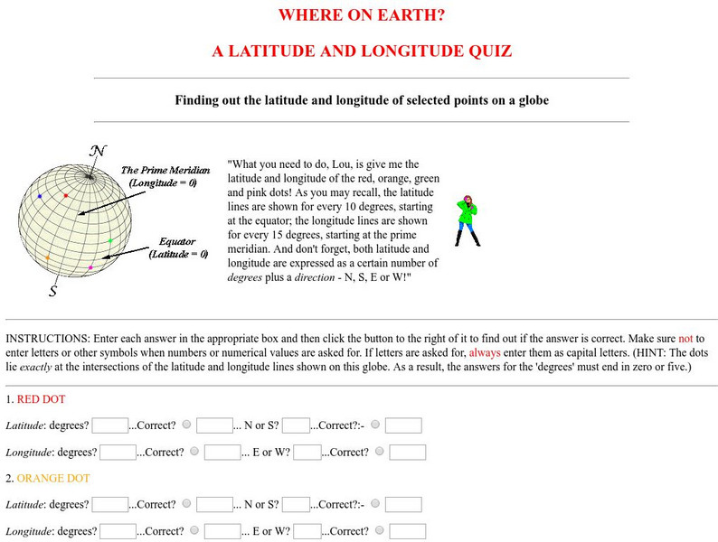
Virtual Geology: Where on Earth: A Latitude and Longitude Quiz
This quiz starts with select points on a globe. Students must determine the latitude, longitude, and direction for each point.
National Geographic
National Geographic: A Latitude/longitude Puzzle
Through examining maps students will be able to identify locations and characteristics of them based on latitude and longitude and infer what events might occur in the places.
PBS
Pbs Nova Online: Lost at Sea the Search for Longitude
"The quest for a reliable method to find your way at sea was one of the thorniest problems of the 1700s." Find out about the search for longitude at this NOVA site. Includes interactive Shockwave game, learning activities and more.
PBS
Pbs Nova: Find Your Longitude
Lost at sea with only your sextant? Use your knowledge of longitude to find your place. The non-shockwave interactive activity makes the concept of longitude concrete.
National Geographic
National Geographic: Introduction to Latitude and Longitude
In this lesson, students learn to determine the latitude and longitude of locations within the United States, while making observations about climate and the ways in which these measurements can be useful. Includes maps and discussion...
Social Studies for Kids
Social Studies for Kids: Latitude and Longitude
A collection of latitude and longitude mapping activities ranging from pin-pointing exact locations on the globe to researching the history behind this basic geography concept.
Diffen
Diffen: Latitude vs. Longitude
Find out about the basics of latitude and longitude with this comparison chart. Then read the article and watch the video to dig a little deeper into the topic.
SMART Technologies
Smart: Latitude and Longitude
Try to locate famous landmarks using latitude and longitude coordinates in this interactive classroom activity.
Pamela Seed
The Art and Science of Fifteenth Century Navigation: Latitude
Chronicle of the changes that occurred in various areas when latitude was identified in 1516. Site includes links to the changes in maps, compass roses, and the science of sailing.
Teachers.net
Teachers.net: Explore Latitude and Longitude With Pumpkins: Lesson Plan
Learners paint pumpkins to make their own globes in this fun way to learn longitude and latitude.
New York Times
New York Times: Crossword Puzzle: Latitude & Longitude
Here is an interactive & printable crossword puzzle developed by the New York Times Learning Network. The theme of this puzzle is Latitude & Longitude.
American Geosciences Institute
American Geosciences Institute: Earth Science Week: Places on the Planet: Latitude and Longitude
Learners learn how citizen scientists involved in the Geological Society of America's EarthCaching project use GPS technology and latitude and longitude coordinates to find special places on the Earth.
Mocomi & Anibrain Digital Technologies
Mocomi: What Is Latitude and Longitude?
Provides interesting facts about latitudes and longitudes including how they are measured, why they are important, and the Halley meridian and Bradley meridian.
NASA
Nasa: Latitude and Longitude
This site from NASA provides definitions of latitude and longitude with good graphics.
The Franklin Institute
Franklin Institute: In Quiry: Minutes From Me: Latitude, Longitude and Vacations
An explanation of latitude and longitude along with a classroom activity that uses the location of students' vacation destinations for charting latitudes and longitudes.
City University of New York
Brooklyn College, Cuny: Latitude and Longitude
Students can read about how lines of latitude and longitude form a grid that makes it easy to pinpoint one's location on Earth. Then they can take an online quiz to check their understanding.
Other popular searches
- Latitude and Longitude
- Latitude Longitude
- Latitude and Longitude Games
- Latitude & Longitude
- Latitude and Longitude Maps
- Longitude and Latitude Game
- Longitude and Latitude Math
- Geography Latitude Longitude
- Whaling Latitude Longitude
- Longitude Latitude Minutes
- Longitude and Latitude Lines
- Volcano Latitude Longitude


