Curated OER
Australia Outline Map
In this Australia and Oceania outline map worksheet, students make note of the major landforms and bodies of water located within this region.
Curated OER
South America: Physical Map
In this South American physical map worksheet, students make note of the major landforms and bodies of water located on the continent.
Curated OER
Asia Physical Map
In this Asia physical map learning exercise, students make note of the major landforms and bodies of water located on the continent.
Curated OER
Lewis & Clark Map
In this Lewis and Clark expedition map worksheet, students examine the route of the expedition and the separate return routes of both Lewis and Clark.
Curated OER
Colonial America 1776 Map
In this United States historical map learning exercise, students examine the colonial boundaries in 1776 as well as the Proclamation Line of 1763.
Curated OER
The 13 British Colonies Map
In this United States historical map worksheet, students examine the 13 colonial boundaries and noted major cities.
Curated OER
California Regions Map
In this California regions outline map worksheet, students examine the coastal, mountain, central, and desert regions of the state.
Curated OER
World Climate Map
In this world climate map worksheet, students examine the tropical, dry, warm temperate, cool temperate, polar and subartic, and highland climate regions of the world.
Curated OER
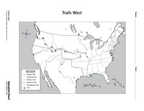
Trails West Map
In this United States historical map learning exercise, students examine the trails that settlers of the Western United States took during the period of Western Expansion.
Curated OER
Inspirational Mapping for the Corps of Discovery
Third graders use a computer software entitled, Inspiration, in order to create a map or web of what Lewis and Clark should have packed for their journey west. They are given the expectations of the teacher and a scoring guide is...
Curated OER
Where in the World Is Mexico?
Students practice map-reading skills as they locate Mexico and its cities on a world map. By creating a puzzle out of a map of Mexico, students engage in a meaningful hands-on activity to help them explore that country's geography.
Curated OER
Will There Be a White Christmas This Year?
Students examine historical weather data, and create map and color key that illustrates the likelihood of a white Christmas in different locations across the United States.
Curated OER
Geography of Canada
All about Canada! Learners explore the geography and providences of Canada by watching videos, studying maps and conducting internet research. By the end of this lesson, your class should be able to locate major areas and compare and...
Curated OER
How Far Is It?
Students use a map key to estimate the distance from Salt Lake City, Utah, to ten other cities. Then they use an online distance calculator to see how close their estimates come!
Curated OER
Solving the Puzzle
Students create a map showing the United States borders at a specific period in history and produce three questions to be answered by examining the map. They also write a productive paragraph explaining who, what, when, where, how/why a...
Curated OER
Weather Lesson Five
Students define a weather forecast, make a forecast using a weather map, identify three prediction guidelines, and explain how computers help to make forecasts. Students make a 24-hour forecast for each of the thirteen states targeted.
Curated OER
The Landscape of a Novel
Learners, after reading a novel, utilize geographic skills to map out the places described in the novel. They collect data, envision spatial features and then design a map to work off of to complete their assignment. Each student also...
Curated OER
Changing Planet: Sea Levels Rising
Begin by showing a six-minute video, Changing Planet: Rising Sea Level as an anticipatory set. Pupils draw a topographic map of a potato continent. Finally, they will visit NOAA's sea levels online map and NASA's carbon dioxide...
Curated OER
Guide to Business Process Modelling
Project managers can add another cog in the wheel of understanding. This guide to business process modelling shows how to construct and use a process map to handle major projects. Tip: While the resource is intended for a vocational...
Curated OER
Summer Shorts
Want to use sequence maps in your narrative writing unit? Young writers work to create personal narratives about their summer vacation. They write a narrative of their vacation and create a display using summer clothing shapes made from...
Curated OER
Exercise Set 2.6: An Introduction to Functions
In this functions worksheet, students solve 70 short answer questions. Students find domain of functions and evaluate them for a given value. Students determine if a mapping diagram represents a function.
Curated OER
Contour Map Worksheet #2
Following a contour map of a hill, a stream, and the ocean, are five multiple choice questions. Earth science enthusiasts determine elevation, direction of water flow, distance, and steepness. They also match the map to a selection of...
Curated OER
A Question of Rivers
Interactive PowerPoints are terrific tools for self quizzing before an exam. This particular presentation is about the action and physical features of rivers. There are nine boxes to click on, each leading to a picture or map. When you...
Curated OER
Tortoise and Hare Races
Practice basic map skills with the story of The Tortoise and the Hare. After listening to the story, class members create a map that indicates the starting line, the path the animals took, where they stopped to rest, and the finish line....
Other popular searches
- United States Maps
- Weather Maps
- Topographic Maps
- Story Maps
- Maps and Charts
- Types of Maps
- Maps and Globes
- Middle East Maps
- Maps and Flags
- Historical Maps
- Maps of Europe
- Create Character Maps


