American Battlefield Trust
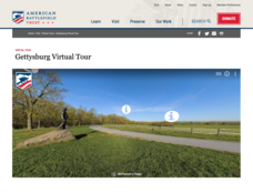
Gettysburg Virtual Tour
Step into one of the most iconic battlefields of the American Civil War with an educational interactive resource. Young historians learn about key moments, locations, soldiers, and turning points in the battle with a clickable map and...
ReadWriteThink
Biography Project: Research and Class Presentation
I Have A Dream ... that after the lesson, all individuals master the reading, writing, researching, listening, and speaking skills the biography project helps them develop. Martin Luther King, Jr. serves as a topic example for a model...
Curated OER
Rivers Run Through It
In this mapping practice worksheet, 5th graders read an informational paragraph and answer 7 questions about the parts of a map along with places shown on a given map.
Curated OER
Dandelion Seed Lesson Plan
Learners create a map using the story The Dandelion Seed by Joseph Anthony. In this early childhood lesson plan, students develop map skills as they illustrate the path of the seed in The Dandelion Seed.
Curated OER
Social Studies: Analyzing Massachusetts Immigration
Students investigate immigration in Massachusetts during the 1990's. They research a series of questions pertaining to immigration, including their experiences, obstacles, and countries of origin. They graph the five most prevalent...
Curated OER
Scaling the Map
Students practice determining map distances using the map scales. They discover how much an area represents on the map in relation to the actual area. They decide on the best place to build their cavern.
Scholastic
Owl Moon Teaching Plan
Capture the engagement of young readers with this collection of activities based on Jane Yolen's book, Owl Moon. Following a shared reading of this children's story, the class explores the geography of the American Northeast, creates...
Smithsonian Institution
Lexington and Concord: Historical Interpretation
Learners view and analyze three different images related to the Battle of Lexington and Concord. They also answer a variety of questions in a graphic organizer to help keep the information straight.
Curated OER
Mystery State #40
In this mystery state activity, students answer clues arranged from difficult to easy to identify the state, then locate it on a map.
Curated OER
The Acadian Odyssey
The dispersion of the Acadians is outlined in this informative PowerPoint. Colorful maps help show where different Acadians settled throughout the United States. Tip: After viewing this slideshow, have students create a timeline of the...
Curated OER
Colonial Maps
Students discover the history of America by identifying the traditional colonies. In this U.S. history lesson plan, students examine a world map and identify where the voyagers left from Europe to arrive at the United States. Students...
Curated OER
Grid it, Map it
Students participate in designing a city layout using grids and coordinates. They work on a city space and create a grid on a life size layout on the gym floor.
United K12
Jan Brett Author Study
Expose young children to the wonderful works of author and illustrator Jan Brett using a few of her stories such as Armadillo Rodeo, The Mitten, or Daisy Comes Home through a unit study.
ReadWriteThink
Dear Librarian: Writing a Persuasive Letter
Everyone deserves to read a great book! Here, pupils write a persuasive letter to the school's librarian detailing their favorite story and why it should be found on the shelves. Class members' persuasive reading passages are shared with...
Curated OER
Geography: examining the Glacial Features of Cape Cod
Learners examine satellite images of the glacial features of Cape Cod. They analyze where human activity is located in terms of those features. Students make models of the features, including kettle holes. They also use contour maps...
Curated OER
The Battle of Bunker Hill: Now We Are at War
Students what events in Massachusetts in 1775 demonstrated colonial opposition to Imperial rule. They examine the events related to the Battle of Bunker Hill and determine the differences in the land masses of Charlestown and Boston from...
Curated OER
"Postcard From Bear"
Young scholars complete various activities related to the book "Postcard From Bear." They participate in a shared reading activity, identify the locations in the book on a map, and write a postcard to the bear in the story.
Curated OER
Name the States Worksheet 4
In this name the states worksheet, students examine 6 state map outlines and identify each of them by writing the state names and postal abbreviations.
Curated OER
The Formation and Value of Temperate Grasslands
Students study the Temperate Grasslands biome of North America. They explain that it is an endangered ecosystem because the rich soils have been converted to farming in most areas. They view videos imbedded in this plan, then complete...
Curated OER
A Field of Beans
Beans, or legumes as they are sometimes called, are the topic for an integrated multi-subject lesson. Youngsters will read, write, observe, and research everything there is to know about beans. They read a bean story, conduct a bean...
Curated OER
Paul Revere
Students examine Henry Wadsworth Longfellow's, Paul Revere's Ride, and other pieces of poetry to use maps and literature to investigate geographic concepts. They chart Revere's ride on current Massachusetts maps while working in pairs....
Curated OER
Immigration in Massachusetts, 1880-1920
Learners, in groups, research immigration in America at the turn of the century. They put together a series of original written essays, letters, newspaper columns, etc. that show what it was like to live as an American citizen and as an...
Curated OER
Literature: Mapping the Mockingbird
Students read Harper Lee's To Kill a Mockingbird, focusing on setting. They list items that create mental images of the novel's setting along with location references to characters and events. Using posterboard, they construct physical...
Curated OER
How Many Trees Can You Grow?
Students solve a story problem about how many trees can be planted in a given area. Using a map, they gather information about the size of the area and the dimensions of an acre. They use a specific equation to determine the area of...


