Curated OER
The Big Circle
Students explore geography by participating in a mapping activity. In this concentric ring lesson plan, students utilize a poster board, string and markers to identify their current location within the entire world. Students write about...
Curated OER
War Consumes Europe
How did the world react to Austria's declaration of war? This activity, guided by the McDougall Littell text, World History, has historians examining the beginnings of WWI through cause and effect analysis. Groups reference the text as...
Curated OER
Gardens Throughout the World
Fourth graders study various aspects of gardens. In this garden lesson, 4th graders discover the location of famous gardens on a map. Students research historic gardens.
Roald Dahl
Matilda - The Reader of Books
The titular Matilda from Roald Dahl's famous novel adored books above all things. Discuss why it is important to read stories from across cultures and around the world using the first chapter from the ever-loved story Matilda.
Curated OER
Today's World
While not an exhaustive review of globalization and trade, this overview of the inter-related nature of the economy would be a good tool to use in the classroom. This resource could be used to begin a discussion on the various topics...
Teach Engineering
What is GIS?
Is GIS the real manifestation of Harry Potter's Marauders Map? Introduce your class to the history of geographic information systems (GIS), the technology that allows for easy use of spatial information, with a resource that teaches...
BrainPOP
Latitude and Longitude Differentiated Lesson Plan
Scholars warm-up their map skills with a discussion using location words to describe familiar places. An engaging video informs class members about latitude and longitude. Three leveled activities extend the learning experience for...
Scholastic
Drones Take Off
Ever wonder what drones are doing high above us in the sky? This article gives your class an insight to what those robots in the sky are doing. After reading an article on drone technology, pupils are prompted to respond to a...
Curriculum Corner
Australian Christmas
Where is Australia? How is an Australian Christmas from other Christmases around the world? Learners participate in a mini-research project where they discover what an Australian Christmas is like.
Agriculture in the Classroom
Understanding the Columbian Exchange Through Old World and New World Foods
If you're interested in teaching your class about the impact of the Columbian Exchange on contemporary society, this is worth a look. The plan begins with an introduction to the topic, which stems from a cell phone poll...
Space Awareness
How To Travel On Earth Without Getting Lost
Have you ever wanted to travel the world? Take a virtual trip with a geography lesson that uses longitude and latitude, the position of the sun, an astronomy app, and a classroom globe.
Newspaper Association of America
Community Connections with Geography and the Newspaper
Understanding geography and government begins at the local level. Using maps and the parts of a newspaper, a unit plan introduces the concept of community. It starts with the creation of classroom and school maps, and then moves through...
PBS
Arthur Compass Rose
Keep your class headed in the right direction with this printable compass rose. Large and easy to read with a smiling picture of Arthur in the middle, this resource would make a fun addition to the desk of any primary grade...
EngageNY
Analyzing Author’s Point of View: Chapter 4 of World without Fish
Give me a clue. Scholars work in triads to use highlighters and mark clues that lead to the author's point of view in World without Fish. The Author’s Point of View graphic organizer helps them map out their thoughts.
Curated OER
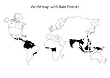
World Map With Rain Forests
In this geography worksheet, students study a map of the world which shows shaded areas indicating where the rain forests are located. There are no labels for countries or continents.
Curated OER
Mapping My World
Students are introduced to simple maps and view a map of a classroom and compare distances of items shown.
Curated OER
Where in the World War? Mapping the Geography of D-Day
Students examine how to read maps for historical information. They listen to a lecture on the history of D-Day, analyze a historical map of the invasion of Normandy, and answer discussion questions.
Curated OER
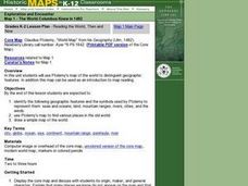
Reading the World, Then and Now
Students distinguish geographic features using Ptolemy's map of the world.
Curated OER
Of Maps and Worldviews
Students explore Ptolemy's world map as an expression of the Renaissance view of the world.
Curated OER
Mapping the War
Students work in pairs to draw their own maps as specified of World War II areas. When all projects have been completed let one group at a time share their assignments with the rest of the class. Compile all the maps into a classroom...
Curated OER
Lesson Design Archaeology- World Map
Students practice locating positions on the world map. In this map skills lesson, students explore the world map and items such as the compass rose, Equator, mountains, cities, etc. The students practice locating positions on the world...
Curated OER
World Map and Globe - Lesson 15 Mountains of the World
Students locate major world mountain ranges. In this geography lesson plan, students identify major mountain ranges on 6 on of the 7 continents on a large world physical map.
Curated OER
Mapping World War II: During and After
In this World War II worksheet, students follow the provided instructions to mark 2 maps according to events and outcomes of the war.
Curated OER
Where in the World Am I: Latitude And Longitude
Learners demonstrate their knowledge in using latitude and longitude measurements to find locations on a map, especially places in Hawaii.
Other popular searches
- World War Ii Map
- World War I Map
- World War 2 Map
- World War I Outline Map
- World Climate Map
- World Biomes Map
- World Outline Map
- Blank Map of the World
- World Political Map
- Ancient World Greece Map
- World Time Zone Map
- Deciduous Forests Map World


