Curated OER
Africa Map Spatial Analysis
In this map skills worksheet, students complete a graphic organizer that requires them to examine what is represented on different types of maps of Africa.
Curated OER
National Expansion
Students investigate the Manifest Denstiny. They explore how the idea was evident in 19th century American maps. Students brainstorm the relationships between maps and national expansion. They review a map from 1816 that called for...
Curated OER
Mapping My World
Students are introduced to simple maps and view a map of a classroom and compare distances of items shown.
Curated OER
Outline Map of Japan
In this geography worksheet, students examine a black line outline map of Japan. There is a compass rose on the page. There are no labeled cities.
NOAA
Into the Deep
Take young scientists into the depths of the world's ocean with the second lesson of this three-part earth science series. After first drawing pictures representing how they imagine the bottom of the ocean to appear, students...
Latin America Network Information Center
Urbanization
Brazil's population has been changing dramatically in the last century. Study the causes of Brazilian urbanization, including industrialization and and migration, and the implications for the country of the populations'...
Association of American Geographers
Project GeoSTART
Investigate the fascinating, yet terrifying phenomenon of hurricanes from the safety of your classroom using this earth science unit. Focusing on developing young scientists' spacial thinking skills, these lessons engage...
Teach Engineering
What is GIS?
Is GIS the real manifestation of Harry Potter's Marauders Map? Introduce your class to the history of geographic information systems (GIS), the technology that allows for easy use of spatial information, with a resource that teaches...
NET Foundation for Television
1850-1874 Homestead Act Signed: The Challenges of The Plains
Start a whole new life in a land known as the Wild Wild West! Learners analyze maps, personal accounts, the Kansas-Nebraska Act, songs, and video clips to uncover life under the Homestead Act. Using their new skills, class members role...
Curated OER
E-mailing the Chamber of Commerce
Encourage effective internet research and e-mail correspondence as scholars investigate a US capital city they've never visited to find pertinent and relevant information. They begin by picking a city, then visit that city's chamber of...
EngageNY
Synthesizing Information: Living Things in the Rainforest
How is a map a type of informational text? Class members view a world map of major rainforests, discussing its text features with a partner. Next, they take notes on key details from multiple texts about rainforests and write an...
Curated OER
Tears of Joy Theatre Presents Anansi the Spider
Accompany the African folktale, Anansi the Spider, with a collection of five lessons, each equipped with supplemental activities. Lessons offer multidisciplinary reinforcement in English language arts, social studies, science,...
Scholastic
The Seven Wonders of the Ancient World
The Colossus of Rhodes, the Hanging Gardens of Babylon, the Lighthouse of Alexandria. Young archeologists investigate the Seven Wonders of the Ancient World, map their locations, and match their names with brief descriptions and images....
Curated OER
Geography Booklet
Sixth graders explore geography terms. Students use resources to find real examples of landforms in the world. They create a map showing the landform. students label the surrounding features, countries and states. Students use each...
Curated OER
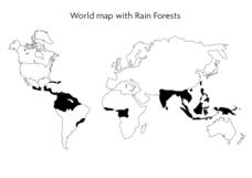
World Map With Rain Forests
In this geography worksheet, students study a map of the world which shows shaded areas indicating where the rain forests are located. There are no labels for countries or continents.
Curated OER
Equator, North Pole, and South Pole
Students identify the Equator, North Pole, and South Pole on the globe. In this map skills lesson, students use a globe marker to locate specific locations on the globe. Students find where they live in relation to the Equator.
Curated OER
Map Study
For this geography worksheet, students study the United States. Students respond to 6 multiple choice questions about the map.
Curated OER
Physical and Human Geography Review Worksheet and Study Guide
In this geography skills worksheet, students respond to 30 short answer questions pertaining to physical and human geography.
Curated OER
Paint My Counties: Map Coloring the Counties of Arizona
Fourth graders identify the counties of Arizona. In this social studies lesson, 4th graders color a county map of Arizona using the fewest number of colors possible. Students write a persuasive paragraph.
Curated OER
Me on the Map: Homes, Neighborhoods, and Communities
Students read a book about maps and identify the differences between a picture and a map. For this maps lesson plan, students also label maps of their home, neighborhood, and community.
Curated OER
Geography, Map Skills & the Internet:
Students research various websites focusing on Italy while enhancing student utilization of computer, keyboards and the Internet. They discuss their findings on the geography, history, topography, and culture.
Curated OER
What Is A Map?
Students become familiar with a map and what it is used for and become familiar with school and home surroundings. With the familiarity of their surroundings they discover that maps can be created to help them with directions and how to...
Curated OER
Map Projections: The Grapefruit Activity
Students partcipate in activities in which they examine different map projections. They discover the positives and negatives of each type. They use grapefruits to help them with the different types of map projections.
Curated OER
Using Maps in the LCTL Classroom
Students review terms and prepositions of location and view a map to illustrate the meanings of the prepositions students are unfamiliar with. They play "Where am I?" game utilizing correct prepositions then they work with a partner to...
Other popular searches
- Geography Map Skills
- Geography Map Reading Skills
- Geography Map Skills Scale
- Geography and Map Skills
- Geography Map Skills Europe
- Usa Geography Map Skills
- Geography Map Skills Us
- Canada Geography Map Skills
- Map Skills Geography Themes
- Geography Map Skills Ohio
- Geography Beginning Map Skills


