Curated OER
We're on the Map!
Young scholars identify a variety of topographic map symbols. They make generalizations about an unidentified community by reading and interpreting map symbols.
Curated OER
Map Reading in the 21st Century
Students interact with MapPoint tools to view maps of the past and the present in multiple ways. They participate in mini-lessons aimed at locating certain points of interest or famous routes taken in history.
National Geographic
The Monsoon
Few things are as fascinating as the challenge of climbing Mount Everest. This lesson plan investigates how monsoon weather impacts climbers. To begin, you are instructed to show various video clips. The only one directly provided,...
Curated OER
Mapping Perceptions
Young scholars create and read maps. In this map skills lesson, students draw a map of their neighborhood, then use skills acquired during map-making to interpret a classmates map and a map of the Ming Dynasty.
Curated OER
Lesson 2: Mapping Our Home
Young scholars recognize the importance of community participation in the census. In this U. S. Census lesson plan, students use map-reading skills to find answers and learn the difference between senators and members of Congress.
Curated OER
Kid Maps: Reading and Creating Maps with Human Characteristics
Students look at maps. In this map lesson, students listen to the book My Map Book by Sara Fanelli and they see the difference between human characteristics (buildings, etc.) and natural characteristics (rivers, etc.). They...
Curated OER
The Interconnectedness of Ancient Peoples Map Study
Seventh graders begin this lesson by viewing various maps of the Ancient World. As a class, they take notes on the changes of different areas in Europe and Asia as their teacher lectures to them. They answer questions about the...
Curated OER
Orienteering - Lesson 4 - Distance and Height
Pretend that you've been dropped onto a mountain, in the middle of nowhere, and all you have to find your way is a topographical map and a compass. Could you find your way to the nearest town? Orienteering teaches the skills of map...
Curated OER
Where Am I: How to Read a Map
Third graders develop an understanding of maps. They explore what a map is, who uses maps, and how to use maps. Students investigate the compas rose. They create a compose rose which illustrates the cardinal directions. Students practice...
Curated OER
Learning About Maps
Students take a "field trip" with the teacher through the school then draw a diagram of what they saw. They bring the maps to the computer lab where they create electronic maps using the software program Neighborhood Map Machine.
Curated OER
Way to Go! Create a Road Map Game
Young scholars create a travel game of one of the United States. They research a state of their choice and create a travel game using a common road map. They interpret map symbols as they calculate map mileage for their games. They...
Tennessee State Museum
An Emancipation Proclamation Map Lesson
Did the Emancipation Proclamation free all slaves during the Civil War? Why was it written, and what were its immediate and long-term effects? After reading primary source materials, constructing political maps representing information...
Illustrative Mathematics
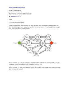
$20 Dot Map
Challenge the addition skills of young learners with this open-ended math problem. The task is simple, get from start to finish by connecting a series of three numbers. The trick is that the sum of the numbers must be less than...
EngageNY
Reading the Map and Beginning Chapter 1
Seventh graders begin their study of Linda Sue Park's A Long Walk to Water by discussing scenarios related to the novel with a partner. The discussion topics invite pupils to consider how various factors, such as war and poverty,...
EngageNY
Establishing Structures for Reading: Getting the Gist (Chapter 1)
Class members review expectations for successful discussions before reading chapter one of A Long Walk to Water by Linda Sue Park. They engage in a think-pair-share to discuss the gist of the text and add their thoughts to their Readers'...
National Museum of the American Indian
The A:Shiwi (Zuni) People: A Study in Environment, Adaptation, and Agricultural Practices
Discover the connection of native peoples to their natural world, including cultural and agricultural practices, by studying the Zuni people of the American Southwest. This lesson includes examining a poster's photographs, reading...
K20 LEARN
Show and Tell Museum - Investigating Primary Sources: Read and Interpret Primary Sources
Scholars become detectives in a lesson that focuses on primary sources. Learners practice their observational skills by examining the teacher's artifact and visiting the Show and Tell Museum that highlihgts items from peers and...
Curated OER
Map Exploration
Are you looking for a terrific instructional activity on map activities for your second graders? Then, this resource is for you! The activities range from decoding, to fill-in-the-blank, to read-and-search. There is a website activity...
Curated OER
Lewis and Clark
Young scholars investigate Lewis and Clark. In this Lewis and Clark lesson, students search the Internet for information about Lewis and Clark and the Corps of Discovery. Young scholars use maps to understand the explorations and decide...
Curated OER
Matthew Henson
Discuss the work of Matthew Henson, an African American who traveled to the North Pole with Robert Peary. After reading the story "Matthew Henson" by Maryann N. Weidt, learners answer questions by drawing inferences and conclusions,...
Curated OER
Elena by Diane Stanley
This story is bound to motivate your class. Learners read a story called Elena by Diane Stanley. The story is about a young woman who marries for love but is soon widowed during the Mexican Revolution. She takes her children to...
Curated OER
The Monkey's Paw
In this reading comprehension worksheet, students complete a variety of activities which demonstrate understanding of the book The Monkey's Paw .
Curated OER
Nazi Concentration Camps -- Map and Chart-Reading Activities
Students use an informational chart about Nazi concentration and death camps to complete a mapping activity and a chart-reading activity.
Curated OER
Map It!
Fourth graders demonstrate map making skills by using the computer to create maps of the geographic features, regions, and economy for their state.


