National WWII Museum
On Leave in Paris: Maps as Primary Sources
Primary sources—even those that seem mundane—offer a window into those who experienced history. Using a Red Cross map offered to soldiers stationed in Paris after World War II alongside worksheet questions, scholars consider what life...
Curated OER
Getting to Know France
In this map skills worksheet, students answer 14 questions about the geography of France. Students then draw a rough map of France. It is assumed that access to an atlas is available.
Curated OER
Creating a Map of France
In this crating a map of France learning exercise, students find and label important parts of France, bodies of water, mountains and surrounding countries.
Curated OER
The French and Indian War
Broaden your history class' knowledge of early America with this presentation, which takes them through the beginnings, battles, and bitter end of the French and Indian War. Vivid maps and paintings help tie the slides together. Note:...
Curated OER
City Life In Europe
Students explore Paris. In this geography skills lesson, students watch "City Life in Europe," and conduct further research on the city of Paris and the country of France. Students create postcards that feature Parisian landmarks.
Curated OER
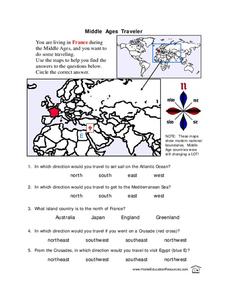
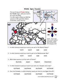
Middle Ages Traveler
In these Middle Ages worksheets, students use the maps to help them find the answers to the questions that help them understand the directions of north, south, east and west. Students also color another map of France according the...
Curated OER
VOYAGE EN FRANCE; French, Travel, Technology
Learners research and plan a simple trip within France. The student gathers information on transportation, lodging, food, tourist attractions and climate. The student then presents the researched information to the class in French.
Curated OER
Charles Lindberghs's Flight to Paris
Students practice map skills. In this map skills lesson, students locate the cities of New York and Paris on a map. Students read about the flight made by Charles Lindbergh in May 1927 from New York to Paris. Students answer 8 questions...
Curated OER
Middle Ages Traveler
In this map worksheet, young scholars are given three maps of France to use to answer multiple choice questions. Students complete an activity from the perspective of a Middle Ages traveler.
Curated OER
Landmarks in Paris
Third graders create a map of France. They use computers to view an "in flight" movie about Paris. They research Paris using books and the internet. Students practice using the program "Comic Life." They import illustrations for each of...
Curated OER
Project Map: Latitude And Longitude Worksheet
In this latitude and longitude worksheet, students find the coordinates of 14 cities around the world and use this information to complete 14 short answer questions. This worksheet includes online atlas web links.
Curated OER
The Wars of Religion (1560s-1648)
Providing the details of different religious wars in 16th - 17th century Europe, this presentation includes pictures and maps to help contextualize these important events. The last slide prompts viewers to answer a question about the...
Curated OER
The Great War: Evaluating the Treaty of Versailles
Young scholars examine and evaluate the Treaty of Versailles. They read and discuss primary source documents, explore various websites, develop a list of postwar goals for France, Germany, and the U.S., and evaluate whether the treaty...
Curated OER
Choral Music II
In this music worksheet, students look at a map of the world and find the places where the Santa Fe, New Mexico Desert Chorale has traveled. There is little information about music on this page.
Curated OER
Open Cities: Europe
In this European cities worksheet, 10th graders find the countries of Europe on a map, match countries with capital cities, categorize different types of cities and identify cities from pictures and on a map.
Curated OER
Happy Endings: The Final Battle
Fifth graders explore all the myths of the battle of Yorktown. A variety of primary documents are viewed and analyzed for discussion. They become aware that what one sees and hears is not always as it seems in reality. Each group...
Curated OER
Vermont History True / False
In this Vermont history worksheet, students read two and a half pages of information about Vermont history. After reading, students complete 10 true or false questions about what they read.
Curated OER
Weather
High schoolers describe the weather and temperature in the city, state, and/or country in which they live during the 4 seasons.
Curated OER
Art And Ecology: Check Out This Place!
For this art and ecology worksheet, students look at paintings and answer questions, using the painting, a world map and climate. There are 2 pictures, each with its own set of questions.
Curated OER
Pavane pour une Infante Defunte
Students describe the music in terms related to basic elements such as melody, rhythm, harmony, dynamics, timbre, form, style, etc. They identify timbres heard in "Pavane" by movement and respond by movement to timbre.
Curated OER
Visual Arts
Students recognize warm and cool colors in a different medium. They look carefully at slide of medieval stained glass.
University of Texas at Austin
France
Excellent series of maps from University of Texas at Austin - Provides political and shaded relief maps of France and a multitude of historical maps and maps of overseas territories overseas. Also includes maps of several large cities.
Other
France, All You Need to Know
It's not easy to describe an entire country and teach the language on one website, but this publisher has managed pretty well. They cover everything such as general information about France, French language lessons, regional and...


