EngageNY
Examples of Dilations
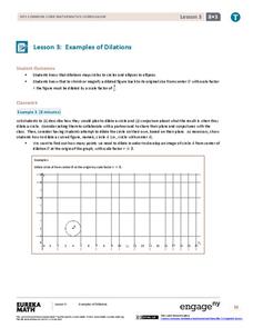
Does it matter how many points to dilate? The resource presents problems of dilating curved figures. Class members find out that not only do they need to dilate several points but the points need to be distributed about the entire curve...
Rainforest Alliance
Knowing the Essential Elements of a Habitat
To gain insight into the many different types of habitats, individuals must first get to know their own. Here, scholars explore their school environment, draw a map, compare and contrast their surroundings to larger ones. They then write...
Mathematics Assessment Project
Geometry
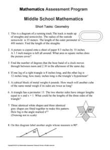
Help learners find joy in facing mathematical challenges. The questions posed on this worksheet encourage young mathematicians to utilize skills learned throughout a geometry unit, and to apply themselves and persevere through problem...
Curated OER
Map Adventures
Students explore the relationship between a scale drawing and actual distance. For this mapping lesson, students use an amusement park map to determine distances and what they would be like in real life.
Curated OER
Three Scale Drawing Activities
In this scale drawing worksheet, students complete three different scale drawing activities. One activity is making a scale drawing, one involves answering questions from a given scale drawing, and one is a cross-number puzzle. The...
Curated OER
Introduction to Field Mapping with a Compass and Pace
Students practice using compass and calibrate their own pace, take field measurements of pre-set course with compass and pace, convert measurements into map, using angles and vectors, and make composite class map by adjusting different...
Curated OER
Scaled Rubber Band Drawings
Students demonstrate the process of creating a scaled rubber band enlargement of a simple drawing. They observe and discuss a teacher-led demonstration, and create a scaled rubber band enlargement of simple drawings and their invention...
Curated OER
What Are Maps For?
Young scholars create a story about a problem someone could have which could be solved by the use of a map. They complete a worksheet that guides them through the features of a map of Chicago. Then they calculate story problems using...
Balanced Assessment
School Zone
Find the right house within walking distance from school. The short assessment has pupils determine the houses that are a given maximum distance from a school. Individuals then determine the shortest and longest walks from the homes that...
Curated OER
Map Your House
Students are introduced to the concepts of maps as scale models of the whole. After a brief lecture on creating and using an accurate scale when drawing and reading a map. They create a scale drawing of the floorplan of their homes.
Curated OER
Draw an Inch, Walk a Mile
Students work in small groups to solve the problems presented. The main project, mapping the classroom, use these discussions to collaborate in creating a tangible demonstration of their understanding.
Curated OER
Stadiums in America
Let's play ball! A great springtime activity to learn about ratios. This activity challenges learners to draw stadiums to scale on standard letter paper and also on construction paper. This three-day lesson plan includes a pre-assessment...
Curated OER
Super Size It, Please!
Pupils take photos from a given distance and determine the height of the person using a scale factor. Pupils calculate the ratio of student actual height to student photo height. They take pictures from 3 different distances to see if...
Curated OER
Our Solar System - Comparing Planetary Travel Distances
NASA presents a mini-unit on distances in our solar system. It incorporates scientific concepts of gravity, mass, density, and payload while your aspiring astronauts also employ mathematics skills. They calculate speed, they determine...
Big Learning
The Antarctica Project: A Middle School Mathematics Unit
Antarctica is a big place, large enough to provide ample opportunities to learn about math. A two-week unit teaches middle school mathematics concepts using project-based learning. The resource covers functions, geometry (area,...
Curated OER
Problem-Solving Decisions: Reasonable Answers
In this problem solving activity, students answer 6 questions pertaining to a story problem about a tabletop scale model of the Nile River.
Science Matters
Finding the Epicenter
The epicenter is the point on the ground above the initial point of rupture. The 10th lesson in a series of 20 encourages scholars to learn to triangulate the epicenter of an earthquake based on the arrival times of p waves and s waves....
Radford University
Earthquake Problem
Shake up things in the classroom. The unit uses earthquakes to bring a real-life connection to finding arc lengths, logarithms, and equations of circles. Small groups determine whether particular towns would have felt an earthquake after...
Curated OER
Measurement 2
In this measurement worksheet, students use liner measure with a provided ruler to determine the distance between objects. Using a map scale, they evaluate the actual distance. Students may use their knowledge of proportions to solve...
Curated OER
Come Into my Parlor
An interesting cross-curricular lesson on dairy farming awaits your young scholars. Elements of language arts, math, social studies, and agriculture are all present. Many excellent worksheets and a good article on dairy farming are...
Curated OER
Scale
Students apply concepts of scales to solve problems. In this geometry activity, students solve real world problems using scales, proportions and ratios. They predict the actual size of a model given the scale drawings.
Curated OER
Scale factors: Ratios and Proportions
Students create building and models using scale factors. In this geometry lesson, students apply the properties of ratio and proportion to solve problems. They identify the means and extremes property of cross multiplication.
Curated OER
Mapping Skills
In this mapping skills worksheet, students practice scale measurements as they respond to 8 questions that require them to measure to scale.


