Curated OER
Living Swamps, Bayous and Forests
Third graders explore interesting environments by exploring Louisiana. In this wetland lesson, 3rd graders utilize the web to research the State of Louisiana, the bayous in the area, and the Gulf of Mexico. Students write a journal entry...
Curated OER
Music - Lesson 16 - Songs
First graders determine that Spanish is the language spoken in Mexico before singing a number of Mexicans songs. They make maracas to use while singing Mexican songs. They sing the song, "La Cucaracha," in English realizing that it is a...
Curated OER
The Influence of Physical Geography
Students explore the limits and demands of their physical world and how it relates to the survival and well-being of people.
Curated OER
Bank Loans Money to Start Businesses
After locating Latin American countries on a world map, children read about how microbanks are loaning money to help start small businesses. Involving both current events and economics, the teacher introduces the article with a map...
Curated OER
Name the States Worksheet 1
For this name the states worksheet, students examine 6 state map outlines and identify each of them by writing the state names and postal abbreviations.
Curated OER
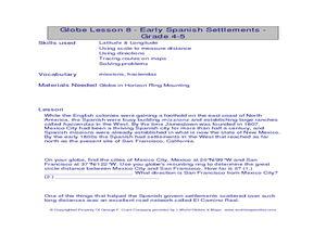
Globe Lesson- Early Spanish Settlements
Students use a globe. In this geography and early settlements lesson, students learn about the settlement of missions and haciendas in New Mexico. Students locate Mexico City and San Francisco on the globe and determine the distance...
Curated OER
Instruments From Around the World
How much does the environment affect how and what man creates? Children explore the effect of the environment on primitive man as they research raw materials from a specific location. They use their findings to write a short essay about...
Curated OER
Chiapas, Where Is It and Why Should We Care? And What Is the EZLN?
Young scholars research and discuss the Zapatista National Liberation Army of Chiapas, Mexico. They role play the involved parties in the conflict and attempt to debate a peaceful solution.
Curated OER
Globe Lesson 4 - Intermediate Directions
Pupils explore the concept of intermediate directions. In this geography skills lesson, students use map skills in order to identify intermediate directions as they complete a map activity.
Curated OER
Topographic Maps Worksheet
In this geography skills worksheet, students respond to 37 multi-part questions that require them to read and interpret topographic maps.
Curated OER
Geography: How do Louisiana Rice Farmers Help the Environment after they Harvest Rice?
Third graders study maps of the United States locating Louisiana, the East Coastal Plain, the Mississippi Alluvial Plain, the West Gulf Coastal Plain, and five of the main rivers. In this geography instructional activity, 3rd graders...
Curated OER
The Day the Water Ran Out
Students explore ecosystems by researching desert characteristics. In this drought lesson, students identify the potential impacts of a drought on their home state and interview people who are familiar with water studies. Students...
Curated OER
Where is Mesoamerica?
Young scholars create a map of Mesoamerica using construction paper, clay or by drawing it. In this World Geography lesson, students determine the location of Mesoamerica, make a map, then present their map to their class.
National Museum of the American Indian
The A:Shiwi (Zuni) People: A Study in Environment, Adaptation, and Agricultural Practices
Discover the connection of native peoples to their natural world, including cultural and agricultural practices, by studying the Zuni people of the American Southwest. This instructional activity includes examining a poster's...
Curated OER
Create a World
Students combine imaginative powers with known map-making techniques to create a whole new world.
Curated OER
Geography Crossword Puzzle
In this history activity, students answer nine questions concerning a variety of states and compass directions including north, south, east and west. Students complete a crossword puzzle.
Curated OER
A Tough Nut to Crack
Children, based on a set of criteria, evaluate the quality of pecans. They research recorded history of pecan trees as well as how their seeds moved across western Missouri into southeastern Kansas, Oklahoma, Texas and Mexico. In...
Curated OER
Pop Around the World
Students study the origin of popcorn. They locate countries where it is grown on a world map. They color the world map and glue kernels of popcorn onto the countries from which popcorn originated. They write the names of common items...
Curated OER
Third Grade Social Studies-Multiple Choice Activity
In this grade 3 social studies activity, 3rd graders complete a set of 25 questions about a variety of topics including geography, types of communities, map and questions about the environment.
Agriculture in the Classroom
Wad-a-Watershed
What kind of impact do humans have on watersheds? Find out in a instructional activity that defines, explores, and promotes ways to protect our watersheds. The ultimate goal of the instructional activity is for learners to discover how a...
Scholastic
Perfect Postcards: California
It's time to hear about some adventures in travel! The Transcontinental Railroad changed life and travel in the United States during the 1800s. Practicing online research skills, pupils discover the features they would like to visit on...
Curated OER
The Conquest of the Aztec Civilization
Young scholars use the classroom atlases, the Internet or textbooks to draw a freehand map. They work in groups using the maps in the book The Broken Spears (Portilla) and The Conquest of New Spain (Diaz) to draw a freehand map...
Curated OER
Exploration and Settlement of the American Southwest
Students scrutinize the Zuni Pueblo Revolt in this seven lessons unit on early Spanish explorers in the American southwest. The discovery of the Spanish missions, the search for the seven cities of gold, and particular geological...
Concord Consortium
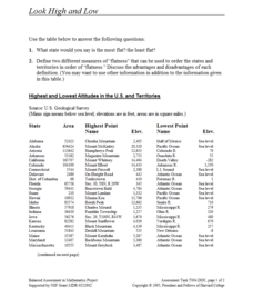
Look High and Low
From the highest high to the lowest low here's a resource that won't fall flat. Given data on the area and the highest and lowest elevations of each of the 50 states, learners decide which states are the least flat and the most flat. Of...


