Curated OER
Foliage Tracker
Young scholars discuss the change of leaf colors and the role that climate and elevation play in those changes. They then track leaf changes, input data, and graph foliage changes with a free online tool.
Curated OER
Rock Cycle: The Story of a Rock
Students examine the rock cycle by watching videos and then use creative storytelling techniques to tell the story of a rock as it undergoes geologic changes.
Curated OER
Superlative Adjectives
In this superlative adjectives worksheet, students read a review of adjectives with -est suffixes, and adjectives followed by of, in, on, etc.. Students apply the information to fill in blanks and create sentences to write twenty-one...
Curated OER
Jonas Salk: He Led the Battle Against Polio
Do you know who Jonas Salk is? Print these pages and have your middle and high schoolers read his biography in Time magazine. The reading itself is short, and it is followed with a key date chart, three reading questions, two connection...
Curated OER
Tennessee Activity
In this Tennessee learning exercise, students read a selection about the history of Tennessee, then complete a set of 10 true/false questions.
Curated OER
Bordering States & VA Regions
In this Virginia geography worksheet, students respond to 2 fill in the blank questions and 16 multiple choice questions regarding the bordering states and regions of Virginia.
Curated OER
Indian Removal: The Cherokees, Jackson, and the “Trail of Tears”
Students examine executive power. In this Indian Removal lesson, students listen to their instructor present a lecture regarding the "Trail of Tears". Students respond to discussion questions regarding the lecture.
Curated OER
Virginia: The Land and its First Inhabitants
Students review the five geographical regions of the state of Virginia. Using a map, they locate and label Virginia, surrounding states and the crops grown in the area. They present their map to the class and complete a worksheet to end...
Curated OER
Let's Go To Mexico
Students are able to use the Internet to conduct research. They research Mexican culture and traditions. Students compare and contrast Mexican and U.S. food and clothing. They convert United States currency to Mexican pesos. Students...
Curated OER
What State Am I?
In these state names worksheets, 5th graders will draw a line from a state riddle to the correct state name. Each riddle includes the state's nickname.
Curated OER
A Guided Journey Into the Past
Fourth graders use guided imagery to discover and judge an alternative way to enjoy artifacts without removing them from archaeological sites.
Curated OER
E-Pal Adventure
Eighth graders develop online writing relationships with students from another area in their state. They write weekly regarding assigned topics, including researching information about the area in which they live.
Other
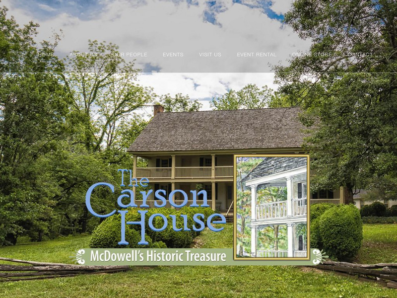
Historic Carson House
If the walls of this house could speak, they would tell a story of North Carolina mountain heritage spanning more than two hundred years.
University of North Carolina
Univ. Of Nc: Impact of Global Warming on Nc's Wildlife & Habitats [Pdf]
Global warming is "the most dangerous threat to the future of wildlife," according to the National Wildlife Federation website. This visual matching activity was designed to engage students in learning about how a variety of NC species...
Pennsylvania State University
Penn State: Still More Plate Tectonics, the Great Smoky Mountains
The Great Smoky Mountain National Park of North Carolina and Tennessee includes 16 mountains over 6,000 feet (about 2,000 m) high, making this generally the highest region in North America east of the Mississippi River. Gatlinburg is a...
State Library of North Carolina
N Cpedia: Catawba River
Catawba River rises in the Blue Ridge Mountains of McDowell County, approximately 20 miles east of Asheville, flowing east-northeast above Hickory until turning southward into the massive Lake Norman Reservoir. It then continues south,...
Curated OER
Educational Technology Clearinghouse: Maps Etc: North Carolina, 1914
A map from 1914 of North Carolina showing the capital of Raleigh, counties and county seats, principal cities and towns, railroads, mountains, rivers, and coastal features. A grid reference in the margins of the map lists counties,...
Curated OER
Educational Technology Clearinghouse: Maps Etc: Western North Carolina, 1920
A map from 1920 of western North Carolina showing the counties and county seats, principal cities and towns, railroads, mountains, and rivers.
Curated OER
Educational Technology Clearinghouse: Maps Etc: North Carolina, 1891
A map from 1891 of North Carolina showing the capital of Raleigh, principal cities and towns, railroads, mountains, rivers, and coastal features.
Curated OER
Educational Technology Clearinghouse: Maps Etc: North Carolina, 1909
A map from 1909 of North Carolina showing the capital of Raleigh, principal cities and towns, railroads, mountains, rivers, and coastal features.
Curated OER
Educational Technology Clearinghouse: Maps Etc: North Carolina, 1919
A map from 1919 of North Carolina showing the capital of Raleigh, principal cities and towns, railroads, mountains, rivers, and coastal features.
Curated OER
Educational Technology Clearinghouse: Maps Etc: North Carolina, 1922
A map from 1922 of North Carolina showing the capital of Raleigh, principal cities and towns, railroads, mountains, rivers, and coastal features.
Curated OER
Educational Technology Clearinghouse: Maps Etc: North Carolina, 1903
A map from 1903 of North Carolina showing the capital of Raleigh, counties and county seats, principal cities and towns, railroads, mountains, rivers, and coastal features.
Curated OER
Educational Technology Clearinghouse: Maps Etc: North Carolina, 1919
A map from 1919 of North Carolina showing the capital of Raleigh, counties and county seats, principal cities and towns, railroads, mountains, rivers, and coastal features.


![Univ. Of Nc: Impact of Global Warming on Nc's Wildlife & Habitats [Pdf] Lesson Plan Univ. Of Nc: Impact of Global Warming on Nc's Wildlife & Habitats [Pdf] Lesson Plan](https://d15y2dacu3jp90.cloudfront.net/images/attachment_defaults/resource/large/FPO-knovation.png)
