Curated OER
The Geography of the United States
Full of bright maps and interesting information, this presentation details U.S. Geography. Slides include basic facts about size, regions, topography, and demographics, as well as fascinating trivia about the United States, including...
World Globes & Maps
United States Map- Intermediate Directions
Students identify the four intermediate directions. For this map skills lesson plan, students use post-it notes to label the four intermediate directions on a map. Students locate various states using intermediate directions.
Curated OER
United States: Physical Features Fun
In this map worksheet, young scholars color and trace eleven listed features on a map of the United States. Students answer six additional questions about the map. A United States map is not provided. However, websites are provided to...
Curated OER
United States Identifier
Fifth graders examine and research a major region of the Unites States in groups of four. In addition, they locate the states, capitals, mammals and two bodies of water or mountain ranges found within their region. After the research,...
Curated OER
U.S. Geography for Children: State Capitals
In this United States map skills activity, students locate and label specified states and their capitals, and create icons and a map key to show something for each state that is famous. Students answer 5 questions.
Curated OER
U.S. Geography for Children: The Northeast
In this map skills of the northeastern United States worksheet, students observe an outline map, locate and label the states, and designated landforms and bodies of water; and create symbols and a map key for sources of economy and other...
Curated OER
Travelogs
Students make travelog journals to send to acquaintances in other states in order to receive mail in return. They make scrapbooks with the return mail they receive.
Curated OER
US: Northeast Region Map
For this United States political map worksheet, students examine the state boundaries of the Northeast Region. The map also highlights each of the state capitals denoted by stars.
Curated OER
US: Northeast Region: Unlabelled
In this United States political map worksheet, students examine the Northeast Region state boundaries. The map also highlights each of the state capitals denoted by stars.
Curated OER
U.S. Geography: The Northeast
Learners investigate U.S. Geography by creating a map in class. In this natural resource lesson, students create a map of the United States and research the Northeast based on their resources and recyclable materials. Learners utilize...
Curated OER
Map Directions and the United States
Third graders search TDC database for images of a compass rose, a miles marker, and a US map. They identify cardinal and intermediate directions to help identify their state and other states on a US map.
Curated OER
Find a Cave
Students locate their own communites and the nearest caves on a United States map. They calculate the distance to the nearest cave using rough scale.
Curated OER
Journey to Gettysburg
Students use latitude and longitude to map the path of the Battle of Gettysburg.
Curated OER
Town Development
Young scholars evaluate how the impact of building of towns affected slavery. In this United States History lesson, students work in small groups to construct a map, then they participate in a role-playing activity.
Curated OER
Searching the Net
Students create a Native American Nation flip book. In this Native American lesson, students choose one of four Native American Nations: The Iroquois, Hopi, Seminoles, Sioux. They research them on the Internet using teacher given...
Curated OER
U.S. Geography- The Northeast
Learners investigate the geography of the Northeast states. In this map skills lesson, students are shown a map of the Northeast states and identify the state names and borders. Learners construct individual maps of the Northeast using...
Curated OER
Children in the United States and Japan
Young scholars locate Japan on a map or globe and describe the relative location of Japan. They use the Internet to investigate cultural characteristics of children in the United States and in Japan. They use a Venn Diagram as an...
Curated OER
The Power of Maps & Native American Cultures
Sixth graders discover where and how five Native American cultures lived in North America in what is currently the United States. They examine their way of life and the regions they inhabited. Additionally, 6th graders will understand...
Curated OER
Fourth Grade Social Studies
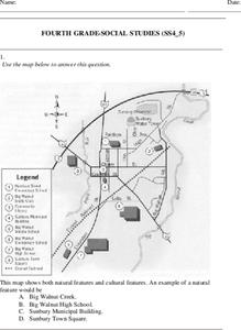
In this social studies worksheet, 4th graders answer multiple choice questions on state maps, city maps, road maps, political maps, and more. Students complete 25 multiple choice questions.
Curated OER
Where Did My Lunch Come From? A U.S. Regional Tour
Students explore the regions from which their food comes. In this social studies lesson, students identify the different agricultural products that are found in the major regions of the United States. Students create a lunch menu.
Scholastic
Owl Moon Teaching Plan
Capture the engagement of young readers with this collection of activities based on Jane Yolen's book, Owl Moon. Following a shared reading of this children's story, the class explores the geography of the American Northeast, creates...
Curated OER
Location, Location, Location!
Twelfth graders locate cities, states and countries on maps. They use the cardinal directions to locate places on maps. They describe where they were born by giving clues without naming the exact state. They trade papers and try to guess...
Curated OER
How the West Was One: A Layered Book
Students create a layered book about the information they learn about the Western region of the United States. In this Western states lesson plan, students create a book about the land, economy, and culture.
Curated OER
Birds of the Northeast
Students identify several common birds through field observations, preserved specimens and personal experience. They classify the species and choose one to research. They draw a migration map and participate in a project that benefit...


