Curated OER
United States Regions
In this United States political map worksheet, students examine regional census boundaries of the US. State boundaries are also included.
University of Richmond
Canals 1820-1860
While canals are not a common mode of transportation today, they were part of the fuel for America's industrialization. However, most of them were located in the North, also feeding regional differences and sectionalism. Using an...
Curated OER
Barrels and Buckets: Access to Water - What Would It Be Like to Live in Africa?
Students compare water access in the United States with that of Africa. In this water access lesson, students located Ghana and Kenya on a globe before reading Peace Corps Volunteer accounts of the difficulty of accessing clean water....
Curated OER
Oh, the Regions
Focus on the geography of Oklahoma. For this activity, learners compare different geographic regions in Oklahoma, create a collage to share their results, and identify important landforms throughout the United States, such as the Rocky...
National Endowment for the Humanities
People and Places in the North and South
North and South: two opposite directions and two opposite economic and social systems in time of the Civil War. Pupils peruse census websites and primary source photographs to understand what life was like for the everyday person before...
Curated OER
Max Knows Mexicao, United States and Canada
Learners utilize their map skills to explore the regions of North America. They explore the physical characteristics and climates of the regions. Students label their map and prepare a presentation of their findings.
Curated OER
From Claws to Jaws: Atlantic Regions of the United States
Students explore New England, Mid-Atlantic, and southeastern regions of the United States. In this social studies thematic unit, students research a state and make a regional quilt. Students wrte a book report and read two novels whose...
Curated OER
Regions of the United States
Fifth graders collect data about regions of the United States using the Internet, library books, and encyclopedias. They write an essay persuading people to visit their state.
Curated OER
The New Madrid Earthquakes of 1811-1812: Shaking Our Misconceptions about Earthquakes in United States History
Students Examine how earthquakes work and what plate tectonics and fault lines are. In this earthquake lesson students complete an earthquake scavenger hunt.
Curated OER
Fifty States Field Day
Students explore the 50 states in preparation for a special field day. On the actual field day, the oldest students in the school manage each of 50 physical activity stations. They share information about each state and introduce the...
Curated OER
The Movement Before the Movement: Civil Rights Activism in the 1940s
Many educators focus on the civil rights movement as it occurred after Rosa Parks incited the bus boycott. Extend the understanding of the fight for civil rights in the United States with this post-WWII instructional activity. Learners...
Curated OER
Desert Ecosystems
Introduce your class to the desert ecosystems using this colorful and informative presentation. This resource discusses desert plants and animals. It also identifies the deserts in the Southwest region of the United States. There are...
Curated OER
Places in Arkansas: A Tour of Our Unique State
A great activity focuses on important cultural and historical places in the state of Arkansas. Learners are introduced to six important places in Arkansas, then create a report on a place in Arkansas. Some excellent photographs, resource...
Curated OER
Regions of the United States
Your learners practice writing ideas on paper and logically presenting them in an organized manner. They brainstorm ways to write down ideas while creating a travelogue about a particular U.S. geographic region. When they present...
University of California
The Civil War: The Road to War
The United States Civil War resulted in the highest mortality rate for Americans since the nation's inception. Delve deeper into the causes for the drastic separation of states with a history lesson plan that features analysis charts,...
US Mint
The Growth of a Nation
Young historians explore the identity of the early United States in this four-part instructional activity series. Working in groups of three, students research the political, economic, and cultural atmosphere of each member of the...
Curated OER
Lesson 1: English-Indian Encounters
What did the English settlers think of the Native Americans inhabiting the Chesapeake region of the United States? Learners analyze a series of documents and images to determine the English perception of the local inhabitants. A great...
Curated OER
Stop the Fighting and Start Uniting
Research current and proposed peace talks around the world with this New York Times lesson, Using the Darfur peace talks in Abuja, Nigeria as a starting point, middle schoolers create a news program on the subject. They propose a future...
CK-12 Foundation
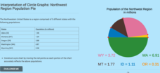
Interpretation of Circle Graphs: Northwest Region Population Pie
Given populations of the five Northwestern states, learners create a circle graph. Using the data and the pie chart, they make comparisons between the populations of the states. Finally, the pupils determine how the chart will change...
National Endowment for the Humanities
The 1828 Campaign of Andrew Jackson: Changes in Voting Participation
Students give examples to indicate how voting participation changed in the first half of the 19th century, and make connections between changes in voting participation and the results of the election of 1828.
Curated OER
Regions of the United States
Students present a travelogue, an alternate format to preparing their writing, of a specific U.S. geographic region that includes the aspects of population, climate, landforms, economics, culture, famous people and places and natural...
Curated OER
Celebrate Kwanzaa in the United States
Students explore and study the celebration of Kwanzaa in which African-Americans remember their heritage and remind people of the importance of sharing with family and friends. They participate in a chant about the seven continents and...
Global Oneness Project
Citizen Photojournalism
Matt Black's photo essay, "The Geography of Poverty" provides a shocking reminder of the poverty that exists in the United States. The resource not only focuses attention on poverty but also conditions that have given rise to situation...
Curated OER
Facts, Fictions and Perceptions of Regions
Students examine the different characteristics of the regions of the United States. They discuss places they have visited in the U.S., and in small groups conduct research on a selected region of the U.S. Each group labels a map of...


