Scholastic
Volleyball Road Trip
Review coordinate mapping with your young geographers by matching cities on a volleyball team's road trip itinerary to their appropriate coordinate locations.
Huntington Library
The Corps of Discovery: The Lewis and Clark Expedition
Don't miss this fantastic comprehensive lesson plan on the Lewis and Clark Expedition, packed with instructional guidance, worksheets, map work, informational texts, and secondary source materials.
Curated OER
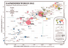
Gapminder World 2012
Here is a very interesting infographic that compares the average life expectancies, per capita incomes, and population sizes of every country in the world in 2012.
Channel Islands Film
Arlington Springs Man: Lesson Plan 4
West of the West's documentary Arlington Springs Man introduces viewers to the remarkable finds on Santa Rosa Island. Archaeologist have discovered on this small island that is part of the Channel island chain, human and pygmy mammoth...
Curated OER
Teaching Elementary School Social Studies
Students identify possible social studies themes that can come from the video, "Voyage of Discovery". They list the five themes of geography. They develop elementary-level interdisciplinary unit plans for social study content. They...
Curated OER
Opening Doors to Social Studies with Children's Literature: The Desert Alphabet Book
Students explore the geography of the United States. In this social studies lesson, students identify the major deserts on a map of the United States.
Foreign Policy Research Institute
A Geography Lesson
Fewer and fewer people have a strong grasp of world geography, but this activity helps students understand geopolitics by creating their own original historical map. The activity requires selecting a country from the list provided,...
Curated OER
My World
Students study maps. In this social studies lesson, students draw a map of either their room at home or the route they take to school. Students label items on their maps.
Alpha Omega
History and Geography—Two World Wars
Here's a combination textbook/workbook that examines the conditions in Europe that lead to World War I. Ideal for homeschoolers as well as classroom use.
College Board
2015 AP® Human Geography Free-Response Questions
How are population and political power related? What is the significance of the globalization of English? Why do refugees leave their home countries? Using structured short-answer questions, scholars unravel complicated dynamics with...
Curated OER
Understanding Geography
Young scholars create a map of their own neighborhood to show the relationships between the geography of the neighborhood and its economy and culture. They view and discuss an introductory video on how geographers study an area then go...
Curated OER
Why All Maps Lie
Eighth graders discover the fundamental advantages/disadvantages of both maps and globes. They see that maps may distort size, shape, distance and direction. They discuss the advantages and applications of 5 types of map projections and...
Curated OER
Africa: Introduction, Geography and Mapping
Students study the geography of Africa through the use of maps. They locate, distinguish, and describe the relationships among varying regional and global patterns of geographic phenomena such as landforms, climate, and natural resources.
Curated OER
Read a Fall Foliage Map
Students examine the purpose of a color key and use a color key to help them read a map.
Curated OER
Where Do I Fit In?: Mental Mapping Student Neighborhoods
Students examine geography through the themes of place, human/environment interaction, and region. They create a mental map of their own neighborhood, analyze their role in the world, and design a neighborhood that reflects their needs.
Curated OER
Introduction to Maps
Young scholars investigate a variety of maps to explain what each one is used for.
Curated OER
Geography With Dr. Seuss
Students read the book, The King's Stilts by Dr. Seuss and discuss the geographical information given in the book. Then they discuss and locate on a map the physical features that make up the continent of Africa. They create an original...
Alabama Department of Archives and History
La Mobile: A Case Study of Exploration and Settlement
The Le Moyne brothers, Jean-Baptiste and Pierre, were among the first explorers of the Gulf Coast. Class members read biographical information and journal entries about these men, study maps showing where the settlements they established...
Curated OER
Decolonization in Asia
Pin point areas in Asia that went through decolonization and regained independence from colonial rule. There are 32 countries and bodies of water to identify on the provided map.
Curated OER
European Language Groups, 1850
Document the linguistic diversity and major language groups common to Europe in 1850. A map and a list of regions, countries, and water ways is provided.
Curated OER
Map Quiz 1
In this map quiz 1 worksheet, learners answer questions relating to geography, not interactively, then scroll down to see the answers.
Curated OER
European Elevation Sort
Given a prepared database of European countries, sixth graders sort the countries in ascending order by elevation and identify the five countries with the highest elevations. This cross-curricular lesson combines elements of computer...
Curated OER
Our States, My State
Here is a very nice lesson plan on the shape of the United States, and the shapes of the individual states for your young geographers. They utilize worksheets embedded in the plan to color in a variety of states and to become familiar...
Society for Science & the Public
Easter Islanders Made Tools, Not War
When studying artifacts, especially tools, how do archaeologists determine what the devices were used for? In what ways might researchers' previous experiences influence their perception of an artifact? An article about researchers'...


