Curated OER
Tour Of South America
Students explore South America. In this geography lesson plan, students research landmarks of historical or national significance and use their findings to create slideshows.
Curated OER
South America Quiz 1
In this South America worksheet, students complete short answer questions on the rivers, countries, sports, and more about South America. Students complete 10 short answer questions.
Curated OER
South America Challenge
In this South America facts activity, students read the statements about South America and select the best choice to complete the 10 statements.
Curated OER
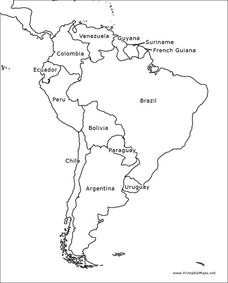
South America Map
In this map of South America worksheet, students identify and label the countries in South America. Students improve their understanding of South America.
Curated OER
The Geography of Latin America
Perfect for a geography or world cultures lesson, the slides in this presentation cover the topography, demographics, and climate of Central America, South America, and the Caribbean. From the apex of the Andes Mountains, to the depths...
Curated OER
South America Map Quiz
In this online interactive geography quiz learning exercise, learners examine the map that includes all of South America's countries. Students identify the 13 countries in 2 minutes.
Curated OER
Mapping South America
Students explore South America. In this South American lesson, students use their geography skills to create population, terrain, biomes/vegetation, and major exports maps. Students present their finished maps to their classmates and...
Curated OER
Countries of South America
Young scholars focus on the geography of the countries of South America. Using a map, they identify the European countries who claimed the South American countries and research the influences they had on South America. To end the...
Curated OER
South America and Central America Capitals Map Quiz
In this online interactive geography quiz worksheet, students examine the map that includes all of Central and South America's countries. Students match each of the country names to the appropriate locations on the map.
Curated OER
South America and Central America Map Quiz
In this online interactive geography quiz worksheet, students examine the map that includes all of Central and South America's countries. Students match each of the country names to the appropriate locations on the map.
Curated OER
El Mundo Hispano
Colorful maps are clearly labeled in this PowerPoint to show viewers where different Hispanic countries are located within Central and South America. Each country is listed on its own slide with a title, the capital, close-up map, flag,...
Curated OER
The Monroe Doctrine: President Monroe and the Independence Movement in South America
Students identify conditions in Europe that relate to the independence movements in South America and list reasons why President Monroe gave for recognizing the independence movement in South America.
Curated OER
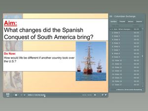
Spanish Conquest of South America
Have your class consider what life in South America would have been like if it were colonized by a country other than Spain. This presentation provides information on the influences and effects of Spanish exploration and colonization of...
Curated OER
Metal Tooling with Colored Pencils
Take your art class back centuries to the art of metal tooling. This is an art technique also referred to as embossing, or repajado in Mexico and South America. This is a fun project to introduce a new technique and new materials. This...
Curated OER
Geography of South America
Student's identify geographic features of a South American map. They use the scale of the map to calculate distances between points. They identify examples of the five geographic themes on the map of South America.
Curated OER
South America/Capitals
In this geography worksheet, students match the countries with the capitals in South America. The answers are found by clicking the button at the bottom of the page.
Curated OER
Colonial North America
Showcase the religion, conflicts, daily life, and politics of Colonial North America. A very well-done presentation highlights all the major colonial groups, social norms, demographics, and political struggles of the time. Perfect for an...
Curated OER
South America Outline Map
In this blank outline map instructional activity, students explore the political boundaries of South America and the nations there. This map may be used in a variety of classroom activities. The map is labeled with the country...
Curated OER
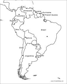
South America Outline Map
In this blank outline map worksheet, students explore the political boundaries of South America and the nations there. This map may be used in a variety of classroom activities. The location of the capital cities are denoted with...
Curated OER
South America Outline Map
In this outline map worksheet, students discover and investigate the physical boundaries of the countries in South America. The names of countries and a star to mark the capital city are included.
Curated OER
South America Outline Map
In this outline map learning exercise, students discover and investigate the continent of South America. No country borders or physical features are depicted. This blank outline map may be used for a variety of classroom activities.
Core Knowledge Foundation
Colonial America Tell It Again!™ Read-Aloud Anthology
A read-aloud anthology explores Colonial America. Third graders listen to informational texts, discuss what they heard, and participate in extension activities and writing. Take-home materials, assessments, and remediation opportunities...
PBS
What's In a Name?
What is in a name? Eager historians trace the geographical history of places in the United States with Spanish names. Using a worksheet activity, clues, and web research developed in conjunction with the PBS "Latinos in America" series,...
Curated OER
Geography of South America
Pupils explore South America. For this geography skills lesson, students watch a video about the geographical features of the continent. Pupils complete worksheets on the topic.


