Curated OER
Geography of South America
Young explorers study South American geography. They study maps and create a physical map of the Andes themselves! They also research the geography, environment, and the culture of the Andes and present a report to the class.
Curated OER
Tour Of South America
Students explore South America. For this geography lesson, students research landmarks of historical or national significance and use their findings to create slideshows.
Curated OER
South America Quiz 1
In this South America worksheet, students complete short answer questions on the rivers, countries, sports, and more about South America. Students complete 10 short answer questions.
Curated OER
The Geography of Latin America
Perfect for a geography or world cultures lesson, the slides in this presentation cover the topography, demographics, and climate of Central America, South America, and the Caribbean. From the apex of the Andes Mountains, to the depths...
Curated OER
Mapping South America
Students explore South America. In this South American instructional activity, students use their geography skills to create population, terrain, biomes/vegetation, and major exports maps. Students present their finished maps to their...
Curated OER
South America Map Quiz
For this online interactive geography quiz worksheet, students examine the map that includes all of South America's countries. Students identify the 13 countries in 2 minutes.
Curated OER
The Rainforest: South America
What can one expect to see in the South American rainforest? Find out where humans sleep, what animals they encounter, what kind of plants they'll see, and what dangers lurk in the tall grasses and dense forests. This is a simple and...
Curated OER
South America and Central America Capitals Map Quiz
In this online interactive geography quiz instructional activity, students examine the map that includes all of Central and South America's countries. Students match each of the country names to the appropriate...
Curated OER
South America and Central America Map Quiz
In this online interactive geography quiz activity, students examine the map that includes all of Central and South America's countries. Students match each of the country names to the appropriate locations on the map.
Curated OER
Countries of South America
Students focus on the geography of the countries of South America. Using a map, they identify the European countries who claimed the South American countries and research the influences they had on South America. To end the lesson...
Curated OER
South America/Capitals
In this geography instructional activity, students match the countries with the capitals in South America. The answers are found by clicking the button at the bottom of the page.
Curated OER
Molas from South America
Third graders research world geography by creating a class presentation. In this South American instructional activity, 3rd graders read assigned text regarding the customs and traditions of different Indian communities in South America....
Curated OER
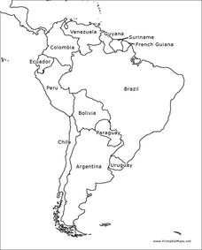
South America Outline Map
In this blank outline map worksheet, students explore the political boundaries of South America and the nations there. This map may be used in a variety of classroom activities. The map is labeled with the country names.
Curated OER
South America Outline Map
In this blank outline map worksheet, students explore the political boundaries of South America and the nations there. This map may be used in a variety of classroom activities. The location of the capital cities are denoted with...
Curated OER
Geography of South America
Students explore South America. In this geography skills lesson, students watch a video about the geographical features of the continent. Students complete worksheets on the topic.
Curated OER
South America Map
In this South America political map worksheet, students examine the country boundaries. The map also labels each of the countries and their capitals.
Curated OER
Geography of South America
Student's identify geographic features of a South American map. They use the scale of the map to calculate distances between points. They identify examples of the five geographic themes on the map of South America.
Curated OER
South American Quiz 2
In this South American worksheet, students complete short answer questions about the history and geography about South America. Students answer 10 short answer questions.
National Geographic
Mapping the Americas
Celebrate the geography of the Americas and develop map skills through a series of activities focused on the Western Hemisphere. Learners study everything from earthquakes and volcanoes of the Americas and the relationship...
Curated OER
The Geography of the United States
Full of bright maps and interesting information, this presentation details U.S. Geography. Slides include basic facts about size, regions, topography, and demographics, as well as fascinating trivia about the United States, including...
Curated OER
Welcome to the Americas
Students research and map the North and South American continents. In this geography lesson on the Americas, students can locate North, Central and South American countries and states. Students choose a location to research and prepare a...
Richmond Community Schools
Map Skills
Young geographers will need to use a variety of map skills to complete the tasks required on this worksheet. Examples of activities include using references to label a map of Mexico, identify Canadian territories and European...
Curated OER
South America Map
In this South American political map worksheet, students examine both national boundaries and national capitals.
Curated OER
Americas: Political Map
In this North America and South America outline map worksheet, students examine the political boundaries of the 2 continents.


