Curated OER
Educational Technology Clearinghouse: Maps Etc: Europe, 1713
A map of Europe after the Treaty of Utrecht at the end of the War of the Spanish Succession, showing country boundaries under control of the House of Bourbon, the Spanish Bourbons, Habsburg, Guelphs, Hohenzollern, and Savoy.
Curated OER
Etc: Claims of Various European Countries to the Us, 1643 1655
A map of the eastern coast of North America showing territorial claims of Europeans and the development of the United Colonies of New England (New England Confederation) in 1643, and the territorial changes between the Dutch and British...
Curated OER
Etc: Maps Etc: European Possessions of Africa, 1906
A map of Africa after the Berlin Conference of 1885, which established the European colonial territory claims on the continent. This map shows the Belgian, British, French, German, Italian, Portuguese, and Spanish claims, and the Turkish...
Curated OER
Educational Technology Clearinghouse: Maps Etc: Northwestern Africa, 1906
Map of Northwestern Africa in 1906 showing the Barbary States of Morocco, Algeria, Tunis, and a portion of Tripoli, the western country of Rio de Oro, and the Upper Guinea States of Gambia, Portuguese Guinea, Sierra Leon, Liberia,...
Curated OER
Educational Technology Clearinghouse: Maps Etc: Oregon Controversy, 1792 1846
A map of the Oregon Territory between the time of exploration by George Vancouver (1792) and the Oregon Treaty of 1846. The map is color-coded to show the disputed claims of the British and United States, the Russian American line of...
Curated OER
Educational Technology Clearinghouse: Maps Etc: Central North America, 1755
A map of central North America showing territorial claims at the beginning of the French and Indian War in 1755. The map shows the Oregon Country, the Spanish claims to New Spain and Florida, the French claims to Louisiana and Canada,...
Curated OER
Educational Technology Clearinghouse: Maps Etc: United States, 1821
A map of the United States and territories in 1821 after the Missouri Compromise, showing the Free States and territories, the Slave States and territories, and the transitional territories at the time. The map is color-coded to show the...
Curated OER
Educational Technology Clearinghouse: Maps Etc: Oregon Controversy, 1792 1846
A map of the Oregon Territory between the time of exploration by George Vancouver (1792) and the Oregon Treaty of 1846. The map is color-coded to show the disputed claims of the British and United States, the Russian American line of...
Curated OER
Educational Technology Clearinghouse: Maps Etc: Colonial Africa, 1914
A map of Africa in 1914, showing the presence of European powers, including British, French, German, Portuguese, Spanish, Italian, and Belgian possessions. Native states, major cities and major railways are also shown. This map reflects...
Curated OER
Educational Technology Clearinghouse: Maps Etc: Claims in North America, 1760
A map of North America in 1760 showing the territorial claims at the time. The map is color-coded to show the claims of the French, English, and the Spanish. The Oregon Country is also shown, however this was a region unexplored by the...
Curated OER
Etc: Maps Etc: United States at the Close of the Revolution, 1789
A map from 1872 of the country east of the Mississippi showing the newly formed United States after the ratification of the Constitution in 1789. The map is keyed to show the states at the time and the Spanish territories of West and...
Curated OER
Educational Technology Clearinghouse: Maps Etc: Europe, 1763
A map of Europe subtitled "The Peace Hubertsburg" or Hubertusburg. The Treaty of Hubertusburg marked the end of the Seven Years' War, and this map shows country boundaries in 1763 under control of the House of Bourbon, the Spanish...
Curated OER
Educational Technology Clearinghouse: Maps Etc: The United States, 1830
A map of the United States in 1830 showing the states and territories, the joint-occupation with Britain in Oregon Country, and the British and Spanish possessions at the time. The map shows the westward expansion of the United States,...
Curated OER
Educational Technology Clearinghouse: Maps Etc: Africa, 1897
Map of Africa in 1897 showing European colonial possessions and spheres of influence, and the independent territories at the time. The map is color-coded to show the areas controlled by the British, French, German, Turkish, Italian,...
Curated OER
Educational Technology Clearinghouse: Maps Etc: Colonial Georgia, 1732 1763
A map of Colonial Georgia, showing the proclamation line of the original United States established at the end of the American Revolutionary War in 1763, the boundary when Georgia was established from the Carolinas as a buffer between the...
Curated OER
Etc: Maps Etc: Old Claims in the Present Territory of the United States, 1763
A map of the present day territory of the United States, showing the European claims to the land before 1763 and the end of the French and Indian Wars. The map shows the claims of the British, French, and Spanish, and shows the...
Curated OER
Educational Technology Clearinghouse: Maps Etc: United States, 1801
A map of the United States in 1801. The map is color-coded to show the States and territory of the United States west to the Mississippi River, the British territories of Upper and Lower Canada, Rupert's Land, and the Bahamas, the French...
Curated OER
Educational Technology Clearinghouse: Maps Etc: Netherlands, 17th Century
A sketch map of the Low Countries in the Seventeenth Century, showing the Netherlands and Spanish Netherlands, important cities, towns, and ports, rivers, and coastal features of the area.
Houghton Mifflin Harcourt
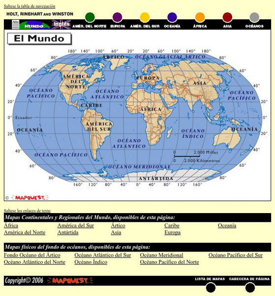
Holt, Rinehart and Winston: El Mundo
This is an online resource in Spanish to the countries of the world, detailed maps of these countries from Mapquest, their flags, and statistical data. Statistical data includes literacy rates, industry, agriculture and natural...
Houghton Mifflin Harcourt
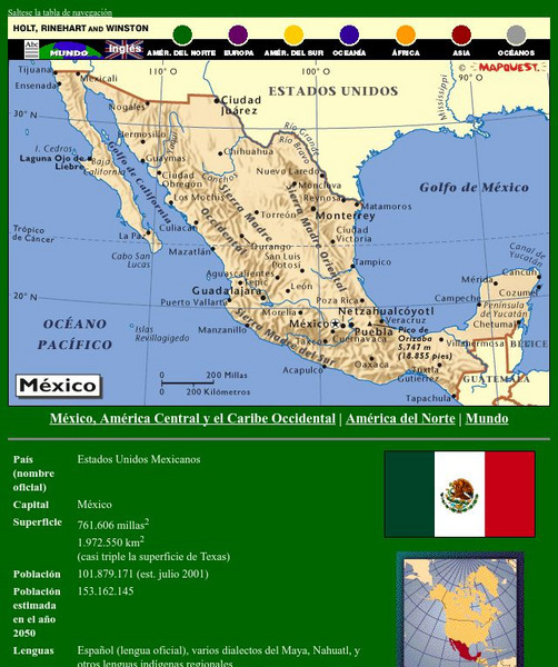
Holt, Rinehart and Winston: America Del Norte: Mexico
This site has a map of Mexico in Spanish, with informational data also presented in Spanish about the country. Land mass, population, life expectancy, literacy, industry, agriculture, minerals and resources are among the topics...
Houghton Mifflin Harcourt
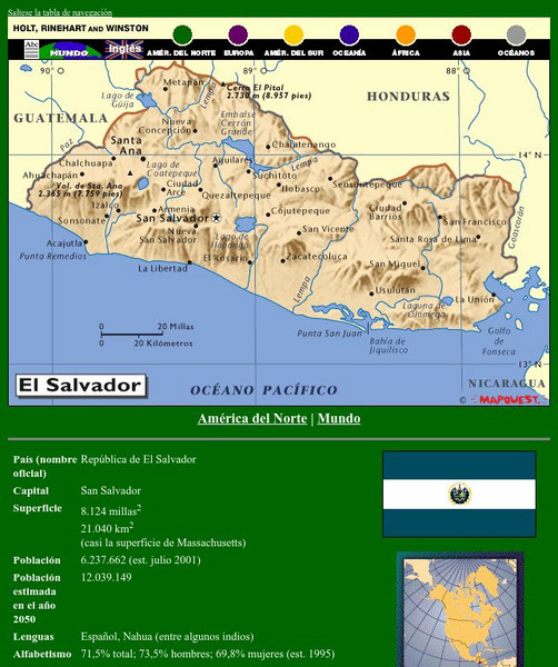
Holt, Rinehart and Winston: America Del Norte: El Salvador
This site has a map of El Salvador in Spanish, with informational data also presented in Spanish about the country. Land mass, population, life expectancy, literacy, industry, agriculture, minerals and resources are among the topics...
Houghton Mifflin Harcourt
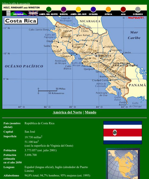
Holt, Rinehart and Winston: America Del Norte: Costa Rica
This site has a map of Costa Rica in Spanish, with informational data also presented in Spanish about the country. Land mass, population, life expectancy, literacy, industry, agriculture, minerals, and resources are among the topics...
Houghton Mifflin Harcourt
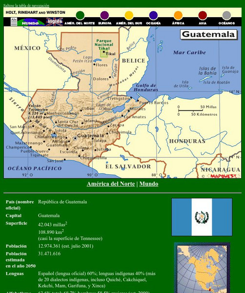
Holt, Rinehart and Winston: America Del Norte: Guatemala
This site has a map of Guatemala in Spanish, with informational data also presented in Spanish about the country. Land mass, population, life expectancy, literacy, industry, agriculture, minerals, and resources are among the topics...
Houghton Mifflin Harcourt
Holt, Rinehart and Winston: America Del Norte: Honduras
This site has a map of Honduras in Spanish, with informational data also presented in Spanish about the country. Land mass, population, life expectancy, literacy, industry, agriculture, minerals and resources are among the topics...


