Curated OER
Plate Tectonics
Students identify the three layers of the earth: core, mantle and crust. They demonstrate knowledge of the concepts of convergent and divergent motions of the earth and an understanding of plate tectonics.
Curated OER
Earth Composition and Plate Tectonics
Students investigate the composition of the interior of the Earth through a teacher lead instructional activity. They study the theory of plate tectonics before creating a model of the earth's interior. They use a hard boiled egg to...
Curated OER
Lithospheric Plate Questions
In this plate tectonics worksheet, students list the major and minor plates. Students determine which plates correspond to the Mid-Atlantic Ridge and Ring of Fire. This worksheet has 10 fill in the blank questions.
Curated OER
Tectonic Processes
In this earth science worksheet, students find the words that help define plate tectonics and the answers are found by clicking the link at the bottom of the page.
Curated OER
Plate Tectonics
In this geology worksheet, learners will cut a map of California along the San Andreas fault line to see how California might change in the future. Then students will compare a world map from 50 million years in the future with a present...
Curated OER
Active Volcanoes, Plate Tectonics and the "Ring of Fire"
In this volcanoes, plate tectonics and "Ring of Fire" worksheet, students view the location of volcanoes on a map of the Earth, they see the "Ring of Fire" and they locate the major plates of the Earth's crust. They use the map as...
Curated OER
The Ocean Floor
Practice reading comprehension by approaching oceanography through 2 pages of informational text. The text compares the ocean floor to the Grand Canyon to gives learners perspective, and gives a brief coverage of the earth's crust and...
Curated OER
ESRI Live Earthquake Site
Students examine a World map and find earthquakes near plate boundaries. They locate and describe earthquakes in the United States and California.
PBS
Earthquakes and Volcanoes
Earth's surface constantly changes thanks to a variety of geological forces; in fact, Australia currently moves faster than GPS technology. Scholars connect the idea of continental drift to earthquakes and volcanoes with the help of an...
Curated OER
Islands, Reefs, and a Hotspot
Learners describe eight stages in the formation of islands in the Hawaiian archipelago. They examine the movement of tectonic plates in the Hawaiian archipelago region, and describe how plate movement produced the Hawaiian archipelago.
Curated OER
Plate Tectonics
Seventh graders develop an understanding of plate tectonics. In this plate tectonics instructional activity students plot earthquake and volcano locations.
Curated OER
Plate Tectonic-Hazards
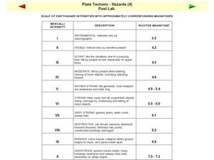
In this plate tectonics instructional activity, students are given a table with the Mercalli intensity of earthquakes, a description of what happens at each intensity, and the Richter magnitude of the earthquakes.
Curated OER
Earthquakes and Plate Tectonics
Students research about earthquakes that took place within a certain distance from their place. In this geology lesson, students explain why earthquakes occur. They analyze patterns of different earthquakes using a computer program.
Curated OER
Pangaea Puzzle: Exploring the Tectonic Forces That Shape the Earth
Sixth graders follow in the footsteps of early scientists as they put the pieces of Pangaea back together and discovered the forces that create the variety of landforms and sea-floor features of our Earth.
Curated OER
How Does Your Magma Grow?
Students identify the three types of plate boundaries and the Earth's tectonic plates system. They examine how the Galapagos Islands were formed and hydrothermal vents.
Curated OER
Converging Earthquake!
Students identify the fault lines and tectonic plates on the map. In this earth science lesson plan, students simulate landscape formation using robots. They take a quiz at the end of the lesson plan to demonstrate mastery.
Curated OER
Striking Earthquake!
Students simulate strike slip faults using CEENBoTs. In this earth science lesson, students identify the fault lines and tectonic plates on a world map. They label the different parts of a fault line.
Curated OER
Normal (dip-slip) Earthquake!
Students label the fault lines and tectonic plate boundaries on the world map. For this earth science lesson, students simulate ocean floor formation using CEENboTs. They explain the causes of earthquakes.
Curated OER
Roots of the Mariana Arc
Plumb the depths of the Submarine Ring of Fire and explore seismic waves with this lesson. Junior geologists simulate s-waves and p-waves, calculate their speeds, and then apply the data to discover the material that makes up inner...
Curated OER
Plate Patterns
Students read about a volcano and use the latitude and longitude information to plot and describe the volcano on the map. They discuss patterns seen on the map. In addition, they color code a map according to zones, plates, etc.
Curated OER
Journey Through Earth
Students study plate tectonics. In this plate tectonics lesson students build a cutaway scale model of the Earth.
Curated OER
Plate Tectonics
In this science worksheet, 6th graders find the words related to the concept of plate tectonics and the answers are found at the bottom of the page.
Curated OER
Convection in a Pan
Students explore convection. In this lesson on heat and energy, students investigate how heat moves in convection currents. They use their finding to better understand how convection currents effect the movement of tectonic plates.
Curated OER
Earth Forces
Students use geological techniques such as plate tectonics, mountain building, earthquakes, and volcanoes, in order to explain the earth.
Other popular searches
- Map of Tectonic Plates
- Floating Tectonic Plates
- Geography Tectonic Plates
- Pacific Basin Tectonic Plates
- Movement of Tectonic Plates
- Tectonic Plates Converge
- Tectonic Plates Move Apart
- Tectonic Plates Oranges
- Edible Tectonic Plates
- Tectonic Plates and Volcanoes


