Curated OER
Rock On!
After five class sessions, young scientists will be able to identify common rock types: igneous, sedimentary, and metamorphic. This plan involves hands-on activities, includes various handouts and worksheets, and requires there to be...
The New York Times
Stress Less: Understanding How Your Mind and Body Respond to Anxiety
What could be more relevant to teens and preteens than experiencing stress? Use an article from the New York Times website to practice valuable Common Core skills for informational text reading, and also get a discussion going in your...
NASA
Earth's Global Energy Budget
Introduce your earth science enthusiasts to the earth's energy budget. Teach them using an informative set of slides that include illuminating lecturer's notes, relevant vocabulary, embedded animations, colorful satellite maps, and a...
NASA
Erosion and Landslides
A professional-quality PowerPoint, which includes links to footage of actual landslides in action, opens this moving lesson. Viewers learn what conditions lead to erosion and land giving way. They simulate landslides with a variety of...
SPARK
Soccer Self-Check
Top taps, slide taps, and drop taps...oh my! Here is a fantastic worksheet that you can use in your class to support both practicing and assessing basic soccer maneuvers, such as pulling back, dribbling, and alternating feet.
Curated OER
Thanksgiving Acrostic Poems
Students watch streaming video, Holiday Facts and Fun: Thanksgiving, define and discuss acrostic poetry, complete circle map using words associated with Thanksgiving, and create acrostic Thanksgiving poems to be typed in Microsoft Word...
Curated OER
Reshaping the Nation
Students learn why the census makes a difference. In this U.S. Census lesson plan, students learn how to read and use a cartogram while they explore new ways to represent data.
Curated OER
Number Types: Where Vocabulary Meets Numbers
Rational, irrational, real, natural. All these words can refer to numbers. Who knew? Learners use the Visual Thesaurus and a semantic feature analysis grid to examine the different attributes of numbers. Step-by-step instructions for...
Curated OER
Global Studies I: Rise of Civilizations
Providing a list of presentations on a variety of topics focused on the development of civilizations throughout the world, this resource could be used in both an upper elementary or high school class. A few important topics covered are...
Center Science Education
Tracking Hurricane News
Here is a unique twist for your lesson on hurricanes. After examining extreme weather news headlines, your storm chasers view a PowerPoint about hurricanes and then zoom in on Hurricane Irene. They map a timeline of her trek up the East...
Curated OER
Navigation Across the Seas
Students examine nautical navigation and discover the differences between nautical charts and other types of maps or charts. Students practice setting a course, taking a bearing, and dead reckoning. This gives students an example of...
PBS
The History of Book Banning in America
Harry Potter, Are You There God? It's Me, Margaret, To Kill a Mockingbird. Kids view a slide show and then discuss the seven banned books featured in the presentation and the reasons why the books may have been banned.
NOAA
Thunderstorms, Tornadoes, Lightning. . . Nature's Most Violent Storms
Thunderstorms, tornadoes, floods, and hail are just a few of the topics covered in a thorough weather preparedness guide. With descriptions of each weather phenomenon, from what causes them to how and when they occur to...
A to Z Teacher Stuff
Facts About Australia
Here is a quick printable with some basic facts about Australia, such as its population, area, type of government, and currency, as well as a simple drawing of an outline of the country.
Mathematics Assessment Project
Middle School Mathematics Test 3
Real-life mathematics is not as simple as repeating a set of steps; pupils must mentally go through a process to come to their conclusions. Teach learners to read, analyze, and create a plan for solving a problem situation. The...
Mathematics Assessment Project
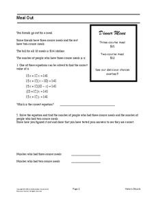
Meal Out
Middle schoolers identify an equation in one variable that models a restaurant order. They then solve the equation to determine the number of people who had each type of meal.
University of Waikato
Investigating Soil Moisture Content
Class members analyze the water content in soil samples by drying out the samples and taking measurements every minute until all the moisture is gone. Scholars compare the initial weight to the dried weight to calculate the percentage of...
Curated OER
Our City
Second graders familiarize themselves with the town they live in by practicing their imagination, library research and writing skills.
Curated OER
Geography and Topography, History and Architecture
In this social studies lesson plan, students answer short answer questions about the geography, topography, history, and architecture of the east part of the United States. Students complete 24 questions.
Curated OER
Geography of the Harbor
Students study estuaries and their boundaries. In this investigative instructional activity students locate an estuary on a map and use nautical and topographical maps.
Curated OER
Planet Earth
Students explore and analyze data from different maps in order to explain geographic diversity among the continents. Student groups research continents' physical features and examine how they contribute to quality of life for inhabitants.
Curated OER
Mapping My Community
Ninth graders are introduced to GPS technology. They complete fieldwork as they visit a specific area of their community to identify and map types of land use in the surveyed area. They use the collected data to create a digital map.
Curated OER
The Great Topo Race
Students create a three dimensional island out of cardboard to examine how to read and use a topographical map. They make sure that their island can sustain life and that it has one volcanic mountain peak. They trace the parts of their...
Curated OER
Mapping the changes in Canada's population
High schoolers find and analyze data found in the census. They compare the population from 1996 to 2001. They explore the type of data they can find in the Census of Population.
Other popular searches
- Different Types of Maps
- Reviewing Types of Maps
- Types of Maps Grids
- Types of Maps Worksheets
- 10 Types of Maps
- Three Types of Maps
- 2 Types of Maps
- Types of Maps Australia
- Types of Maps "Australia
- Types of Maps "Australia"
- Maps Types Key Symbols


