Curated OER
Weather Pals
Learners study maps of the United States to locate weather pals from a list of schools. They communicate with Weather Pal schools through the use of closed circuit TV. Using weather data collected in their area, they exchange the...
Curated OER
United States Geography and Topography
Fifth graders recognize the major regions of the US while reading a map. Students study the physical features of the US. Student research and report on states and their capitols.
Curated OER
U.S. States - The Midwest States
In this geography and math learning exercise, students complete the simple addition equations and match the sums to the colors. Students then color the Midwest States by the color code.
California Polytechnic State University
Australian Geography Unit
At the heart of this resource is a beautifully detailed PowerPoint presentation (provided in PDF form) on the overall physical geography of Australia, basic facts about the country, Aboriginal history, and Australia culture and lifestyle.
Civil War Trust
Contrasting the North and South before the War
Learners create a standing cube with four panels that display information on the North and South's economy, geography and climate, society, and means of transportation before the Civil War. Through discussion and reading...
Global Oneness Project
Citizen Photojournalism
Matt Black's photo essay, "The Geography of Poverty" provides a shocking reminder of the poverty that exists in the United States. The resource not only focuses attention on poverty but also conditions that have given rise to situation...
Curated OER
States and Capitals Unit
Fifth graders explore the regions, states, and capitals that make up the United States. Through the five lessons in this unit students locate and name the fifty states and their capitals.
Curated OER
U.S. Geography: The Northeast
Students investigate U.S. Geography by creating a map in class. In this natural resource lesson, students create a map of the United States and research the Northeast based on their resources and recyclable materials. Students...
Curated OER
States And Shapes
Students work together and investigate the shapes of 50 states. They identify the states that they find hardest to recognize. The group then list the states in order from most difficult to just difficult to recognize and create a...
Curated OER
America Will Be
Students work together to research and create different types of maps of the United States to be used as part of a geography trivia game.Groups research North American annual rainfall, climate, mountain ranges major rivers and state...
Curated OER
Opening Doors to Social Studies with Children's Literature: The Desert Alphabet Book
Students explore the geography of the United States. In this social studies lesson plan, students identify the major deserts on a map of the United States.
Curated OER
US Geography Crossword
In this 50 states worksheet, students complete a crossword puzzle with facts about US geography. There are 22 words to fit in the puzzle, which has no word bank.
University of New Mexico
Let's Travel
Fourth graders work in groups to research various locations across the United States. They present their findings to the class, participate in a travel fair, make phone calls to tourist agencies and write letters to state tourism...
Curated OER
State Capitals- Online Interactive
In this state capitals worksheet, students learn to match the capital cities to the 50 states. Next to each name of the state, students fill in the capital city from a list that is provided. This is an online interactive worksheet.
Curated OER
United States Capitals Map Quiz
In this online interactive states and captials quiz worksheet, students examine the 50 pictured states and try to name all of the state capitals.
Curated OER
Geography of China (Tibet)
Sixth graders study the geography of Tibet. They create maps of Tibet. Students predict population, land area, water area and coastline length of the United States and Tibet. Students compare and contrast the day-to-day lives of people...
Curated OER
The Tet Offensive and the Vietnam War
Learners discover how the United States became involved in the Vietnam War, the importance of the Tet Offensive in turning American public opinion against the war, and how the Vietnam War is still a part of American life and culture.
Digital History
The New Nation
George Washington and the new nation of the United States of America faced many problems in their inaugural years. Use this worksheet as a straightforward approach to learning about the reasons the country was experiencing a lack of...
Curated OER
Geography: Physical Features
Physical features in our geography are outlined in this colorful PowerPoint. First, different physical features are listed. Then, they are defined with a corresponding graphic. Tip: While presenting this slideshow to your class, ask them...
Curated OER
Police Action: The Korean War, 1950-1953
Students explore why the United States became involved in the war in Korea. They discuss the confict between Truman and MacArthur, culminating in the latter's dismissal from command. They identify on a world map foreign countires...
Curated OER
Maps
If your students are just starting a unit on Geography this could be the introduction you're looking for. This PowerPoint presents a clear and organized overview of the different types of maps people use and why each is important. Tip:...
Curated OER
States/Capitals L-N: Matching
In this geography practice worksheet, students match the 17 listed states to the appropriate 17 listed capital cities located in the United States.
Curated OER
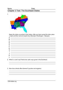
Chapter 3 Test: The Southeast States
In this geography worksheet, students complete a test about the southeastern United States. They name the states, tell about the climate and crops, complete a matching activity about the landforms. and another about the industry.
National Endowment for the Humanities
Hopi Place Names
What's in a name? Historians consider the question as they examine places important to the Hopi people and the meanings of their place names. Included worksheets include maps and charts to help class members examine the geography of Hopi...
Other popular searches
- Geography of United States
- Geography United States
- Geography of the United States
- United States Geography Unit
- Physical Maps United States
- United States Geography Maps
- United States Geography 4 6
- Picture United State Maps
- Physical Maps of United States


