Curated OER
Salt Relief Map of Virginia
Fourth graders create a salt relief map of the four regions of Virginia. They indentify land forms and bodies of water, and summarize how they made their project.
Curated OER
Three Mapping Activities
Students label three maps of China after being introduced to background information about the country. For this geography lesson, students color two maps and label various points of interest in China. Finally, students draw...
Curated OER
Backyard Map- Measuring with Centimeters
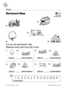
In this backyard map centimeter measurement worksheet, 1st graders cut out a centimeter ruler from the bottom of the page. They use the ruler to measure the path between objects which are pictures in the backyard map at the top of the...
Curated OER
Materials: Hidden Costs, Mapping the Source and Cost of Raw Materials.
Young scholars map connections among raw materials. In this environmental stewardship lesson, students design strategies to minimize the use of raw materials and discuss how to use more sustainable materials.
Curated OER
United States Regions
In this United States political map worksheet, students examine regional census boundaries of the US. State boundaries are also included.
Curated OER
Middle East Geography Worksheet
In this geography skills worksheet, learners examine the provided map of the Middle East, identify the noted countries, and write facts about each of the countries.
Curated OER
Japan's Geography Worksheet
In this geography skills worksheet, students label a map of Japan and then respond to 8 short answer questions about the country.
Curated OER
Making a Travel Brochure of a Louisiana Parish
Although the attachments for this travel brochure project are no longer linked, you can still use the idea here and create your own assignment sheet and rubric. Learners choose a parish in Louisiana (or a city in your state) to research,...
Curated OER
Mapping the Lewis and Clark Trail
Students explore how physical and human geography features effected Lewis and Clark's expedition by using the Lewis and Clark Digital Discovery Web site.
Curated OER
Do We Still Need the Electoral College?
One of the most confusing aspects of any presidential election year is the role of the Electoral College. Learners read a bit about how the Electoral College works and then they hold a mock election in their classroom. They'll redraw a...
Curated OER
First Grade Visits...Washington DC
Take your first graders on a virtual trip to around Washington, DC. This presentation provides illustrated slides featuring a map showing the location of Washington, DC, the White House, and some of the more famous memorials and...
Wind Wise Education
Where is it Windy?
How is the wind up there? The class builds a topography model using materials available in the classroom, then place wind flags in different locations on the landscape. Using a fan as a wind source, pupils collect data about how wind...
Curated OER
Map It Out
Explore how illustrations add to a story. Young learners will look at picture books to see how the pictures tell the story. They create illustrations to go with a chosen story, and then flip the activity so they have to write a story to...
John F. Kennedy Presidential Library & Museum
Red States/Blue States: Mapping the Presidential Election
Young historians investigate how voting patterns have changed by comparing the outcome of the 1960 election to the outcome of the recent election. A creative final assessment has participants making a news show wherein they provide...
Rainforest Alliance
How Do Jaguars and Howler Monkeys in Belize Depend on Us?
How does weather play a role in the lives of land and sea creatures? Find out with a instructional activity focused on habitats and the ways animals from different homes are connected. Here, learners explore how the life of a...
Advocates for Human Rights
Human Rights Defined
Class members continue their investigation of the factors that influence migration with a lesson on human rights. As they examine the Universal Declaration of Human Rights and selected US Constitutional Amendments, learners compare the...
Scholastic
Tell Us a Tale: Teaching Students to Be Storytellers
Encourage scholars to retell their favorite short story or folktale, adding personal details to make it their own. After reading their book of choice several times, story tellers retell a tale verbally to their classmates.
CK-12 Foundation
Midpoint and Segment Bisectors: Midpoint Map
Discover how to find a midpoint with a conceptual exploration. Scholars manipulate a point to determine the location of a midpoint on a straight line distance between two locations. Later questions extend to determine the...
CK-12 Foundation
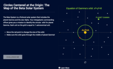
Circles Centered at the Origin: The Map of the Beta Solar System
Calculate galactic orbits in a far-out resource. Pupils drag a point on a circle to graph the orbit of a fictional planet. Using the equation, they find points through which the orbit passes. To finish the simulation, users determine the...
College Board
2003 AP® Human Geography Free-Response Questions
What role has tourism played in changing the landscape of a country? How do human migration patterns affect a nation? To what extent can urban development patterns help us understand our cities? Learners explore these ideas and more...
National Woman's History Museum
19th Amendment
As part of a study of the women's suffrage movement and the ratification of the Nineteenth Amendment, young historians examine documents that detail when voting rights were granted to women in various countries and when US states...
Curated OER
Mapping a Stream
Students map an actual local waterway. They create full color scale drawings that include windfalls, plant cover, streambed composition, and landmarks such as trees, boulders, and slumps. This is a long-term project that involves...
Curated OER
Our Class Is On the Map
Second graders review map keys, symbols, and the purpose of maps, then students design a poster size map of their classroom.
Curated OER
ESOL School Map Identification
Pupils review a school map and identify areas along with vocabulary words. They label a map as a class then create corresponding flash cards and practice new vocabulary flash cards in pairs.
Other popular searches
- Us Map 13 Colonies
- Us Imperialism Map Activity
- Us Map Skills
- Geography Map Skills Us
- Blank Us Maps
- Northeast Us Map
- Northeast Us Map Skills
- Map of Us
- Us Maps of States
- Us States Map Color
- Us Map Activities
- Us States Map Florida


