The Alamo
The Alamo
Remember the Alamo! Scholars investigate the Battle of San Jacinto during the Texas Revolution. Using models, maps, quotes, biographies, and the Oath of Allegiance, the Alamo comes to life as the stories of those who fought and died in...
ProCon
Sanctuary Cities
Should sanctuary cities receive federal funding, or do they defy federal laws? That is precisely the question scholars attempt to answer as they prepare for a class discussion or debate. After reading some brief background information,...
US Mint
Symbols in My Eyes
Explore the hidden meanings behind the images on US currency with this elementary school lesson on symbolism. Starting with a class discussion about symbols, children go on to brainstorm different objects that represent the Unites...
Schools Linking Network & Lifeworlds Learning
How Do We All Live Together?
Explore the concepts of community and point of view with these activities complementing the children's book Voices in the Park by Anthony Browne. Following a class reading of the story, ask students to either draw a map of the...
Advocates for Human Rights
Human Rights Defined
Class members continue their investigation of the factors that influence migration with a lesson on human rights. As they examine the Universal Declaration of Human Rights and selected US Constitutional Amendments, learners compare the...
Annenberg Foundation
America's History in the Making: Using Digital Technologies
How can digital technology of today link us to the events of the past? Scholars use technology to uncover the vast number of historical resources available in lesson 12 of a 22-part America's History in the Making series. Using databases...
All for KIDZ
The Orphan of Ellis Island
Everyone comes from somewhere. An interdisciplinary lesson on Elvira Woodruff's The Orphan of Ellis Island includes discussion starter and writing prompts for the novel, as well as a graphic organizer to help learners begin their...
National Wildlife Federation
An Energy Mix: Renewable and Nonrenewable Resources
What did the windmill say about renewable energy? I'm a BIG fan! Lesson three in the series of 12 has classes discuss potential and kinetic energy and then, in pairs, they complete a web quest over the different types of energy...
CK-12 Foundation
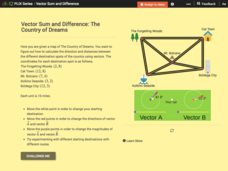
Vector Sum and Difference: The Country of Dreams
Find your way around using vectors. Scholars use an interactive to learn about vector addition. They answer a set of questions about modeling a route on a map using vectors.
Ashbrook Center at Ashland University
Federalist - Antifederalist Debates
Who should have the power—individual states or the federal government? Scholars research the arguments of the Federalists and Anti-Federalists during the formation of the United States Constitution. Online resources, including a vast...
Curated OER
Using Color as a Pre-Writing Tool
To better understand how to compose a clear and well-organized paper, learners read short passages, write summaries, and make colored graphic organizers. This is a fully developed three-day instructional activity with suggested assessments.
Curated OER
Beyond Demographics
Students study the culture of the Dominican Republic. In this Peace Corps lesson, students watch, "Destination: Dominican Republic." Students also examine primary source materials on the nation and discuss their findings.
Curated OER
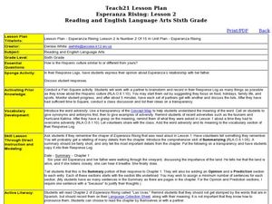
Esperanza Rising: Lesson 2
Sixth graders explore adversity. For this summarizing lesson students compare their culture to the Hispanic culture. Students reflect on a time they were met with adversity. Students summarize Chapter 1 of Esperanza Rising.
Curated OER
Mystery State # 28
Using clues is a great way to increase deductive and logical reasoning skills. Boost thinking skills while quizzing kids about us geography. They use five clues to determine which state is in question.
Curated OER
How Much Water is in That River?
Students practice measurement using the Hudson River. They calculate the discharge measurement at a location on the Hudson River using ingenuity and a topographic map.
Curated OER
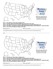
Mystery State #12
What's better than learning about US geography? Having fun while your doing it! After reviewing each of the five given clues, learners attempt to name the mystery state. A great way to reinforce geography skills and deductive reasoning...
Curated OER
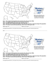
Mystery State # 5
Mystery state number five is none other than Utah! Quiz your kids on state knowledge while building deductive reasoning skills. They use each of the five clues to determine the name of the mystery state. A great warm up when studying...
Curated OER
Create a Story May
First graders review the terms characters, setting and events in stories. They are shown how to access the Kidspiration Map, and how to add pictures in the correct spaces on the map. Students insert pictures in the map of the story...
Curated OER
Where is Flat Stanley?
Students create a story map of the basic elements and significant events of the book Flat Stanley. Students brainstorm places they would like to visit if they had been flattened and then, write about an imagined experience. Students...
Curated OER
Pearl Harbor
Students identify the location of Pearl Harbor and Hawaiian Islands on a map. In this map skills lesson, students use latitude and longitude coordinates to locate various places of importance of the Pearl Harbor attack.
Curated OER
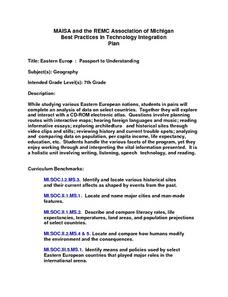
Eastern Europe: Passport to Understanding
Seventh graders explore Eastern Europe. They analyze data on select countries. Students prepare a short oral presentation on the country they researched. They locate their country using an interactive map.
Curated OER
World Map Labels
In this geography skills worksheet, students identify the countries and bodies of water labelled on the maps of the world, Africa, Asia, Canada, Europe, the Caribbean, the Middle East, North America, Australia, and South America.
Curated OER
Defining Regions
Fifth graders will work in cooperative learning groups to research North American regions and create presentations to share with their classmates. To show what they have learned, 5th graders will create maps of North American regions.
Curated OER
Where Has It Been? Tracking the Ivory-Billed Woodpecker
By studying the assumed extinction, and subsequent rediscovery of the Ivory-billed Woodpecker, learners use maps and come up with a scenario for the rediscovery of the bird. This incredibly thorough lesson plan is chock-full of...
Other popular searches
- Geography Map Skills Us
- Northeast Us Map Skills
- Us Map Skills Sheet
- Western Us Map Skills
- Map Skills About Us Census
- Southeast Us Map Skills


