Curated OER
Comparing Countries
Students compare facts about different countries. In this comparing lesson, students collect information about the US and another country and compare them. Students locate countries on the map and make a hypothesis about the lives of...
Curated OER
Radon Gas in the Basement: A Radiation Hazard
For this radon gas worksheet, students read about the harmful effects of radon exposure over time. They use a map that shows radon gas zones to answer 3 questions about exposure to the gas and the amount of radiation that humans get from...
Curated OER
Alexis de Tocqueville’s America
Students analyze de Tocqueville's America. In this democratic history lesson, students use primary sources to determine what de Tocqueville found to be so unique in the America. Students analyze artifacts, maps and documents through...
Curated OER
Drought in Your State
In this drought worksheet, students study the "US Drought Monitor" and complete 8 short answer questions on the causes and effects of drought.
Curated OER
Surrealism
A study of the Surrealist Movement can lead students on an exploration of art, philosophy, and culture.
Curated OER
The Marsh Land as a Changing Environment
Sixth graders continue their examination of the state of Connecticut. After taking a field trip, they identify the types of birds, plants, invertebrates and vertebrates who make their home in the salt marshes. In groups, they identify...
Curated OER
Themes to Encourage Awareness of Environmental Changes on the Shoreline of Connecticut in Elementary School Students: The Case of Kelsey Island
Students begin the lesson by developing a map of Kelsey Island by following specific instructions. In groups, they are given a block of ice in which they tie a rope around and drag over various rocks for different distances. They...
Curated OER
The Four Corners Region of the United States Cultures, Ruins and Landmarks
Learners who live in the inner city are introduced to the four corners region of the United States. In groups, they examine how the region differs compared to where they live and their culture. They develop maps of the area and locate...
Curated OER
Let's Take a Trip!
Sixth graders plan a trip for a family of four choosing their travel plan by studying maps to decide upon a route and visiting Websites to get airline and travel schedules. They use ratios and proportions as well as converting fractions...
Curated OER
D-Day: June 6, 1944
Learners examine the preparations for the invasion of France on June 6, 1944. After viewing a clip from "The War", they identify the demands and concerns of all military leaders for this invasion. They use maps to examine the...
Curated OER
Ninteenth Century Women: Struggle and Triumph
Students examine the role of women in US society during the 19th century and how this role evolved and changed in time. They then write a persuasive letter that domonstrates their comprehensin of the subject.
Curated OER
What Do We Do With A Dirty Bomb?
Students examine composition of dirty bomb and its possible effects on a city, and investigate simulations of such an event; students use computational and problem solving skills to assess damage and prepare report proposing solution to...
Curated OER
Scavenger Hunt
Students explore area around schoolyard by participating in scavenger hunt, examine things that live there, such as noxious weeds, develop observation skills by using five senses, and find and identify ten to fifteen local, natural objects.
Curated OER
How Texas is Planning To Manage Its Water
Students research water management strategies in Texas. They analyze projected demand for water in the year 2050, interpret graphs and tables and then discuss the data as part of a written report. They research and map the locations of...
Curated OER
Lesson 1: The Creek War - Return to Nativism or International Pawn? Religious War or International Conflict?
Students investigate the countries and peoples involved in the Creek Indian War. They study the complex relationships between American and European settlers and the native Alabamians in the early 19th Century.
Curated OER
The School: School Culture Across Louisiana
Students identify and research school customs and folk groups through discussion and interviews. Then they identify and learn that traditional culture exists within other cultural contexts, such as the academic world of school, and in...
Curated OER
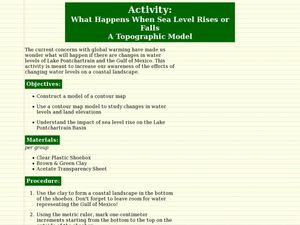
What Happens When Sea Level Rises or Falls
Young scholars examine the impact of sea level on land formations. In this geography and map lesson, students construct a contour map model illustrating how much of the clay "coastline" is covered as water is added. Metric measurement...
Stanford University
Korean War
Learners study the cause of the Korean War. In this World history lesson, High schoolers read excerpts from two different textbooks, one from South Korea, and one from North Korea. They discuss how the cause of the war differs depending...
Curated OER
A Question, Mr. Lincoln!
Students discuss Abraham Lincoln. In this social science lesson, students describe key events in Lincoln's life. Students practice using interviewing skills to gather information pretending to be Lincoln.
Curated OER
Pollution is Not a Solution
Students explore the environment by completing science worksheets in class. In this water conservation lesson, students identify ways water is used in our society and how we abuse the privilege. Students discuss methods to reduce water...
Curated OER
Simple Cycles
Students use Inspiration to map cyclical events. They recognize links between separate events and structural patterns. They explore the Internet Connection section to browse additional resources on teaching about cycles used in...
Foreign Policy Research Institute
Understanding the Koreas
Though this resource was designed in 2005, US tension with North Korea remains a relevant topic for exploration and understanding. Unfortunately, this lecture and reading-based instructional activity is unlikely to engage the class. The...
Curated OER
My Summer Vacation
Students study the United States geography using Google Earth. For this U.S. geography lesson, students create travel journals about five U.S. geographical locations. Students research the human and physical characteristics for each region.
Curated OER
Hidalgo's Fight for the Independence of Mexico
Tenth graders study and examine the life of Miguel Hidalgo while working to identify major themes. Small groups create sequence of event chains, analyze and label maps of Hidalgo's travels, and work together to create giant chalk maps...
Other popular searches
- Geography Map Skills Us
- Northeast Us Map Skills
- Us Map Skills Sheet
- Western Us Map Skills
- Map Skills About Us Census
- Southeast Us Map Skills


