Curated OER
Topographic Mapping Skills
For this geography worksheet, students read an excerpt about topographic maps and why they are useful for various jobs. They also respond to eleven questions that follow related to the excerpt and locating specific map points on the map...
Curated OER
Mapping My World
First graders make two maps. In this developing and reading maps lesson plan, 1st graders read Mapping Penny's World, discuss the parts of a map, create a map of their classroom, and create a list of directions of how to get to various...
Curated OER
Playground Mapping
Students convert their physical models of a playground from a previous lesson into a map of the playground that includes a scale and key. They examine and discuss examples of maps, view an image to map photo essay, and create a map using...
Scholastic
Drones Take Off
Ever wonder what drones are doing high above us in the sky? This article gives your class an insight to what those robots in the sky are doing. After reading an article on drone technology, pupils are prompted to respond to a...
Curated OER
Mapping the News
Students explore cartography. In this map skills and map making activity, Students work in groups to create wall size world maps including legends, compass roses, latitude and longitude, and physical features. Students...
Curated OER
U.S. Political Map
Students explore the symbols found in a map legend. In this map skills lesson, students locate the legend on a political map and explain what each of the symbols mean. Students locate and identify several symbols on the map.
Curated OER
Cinderella Map Key
Students design a map key in order to show where the different Cinderella stories have taken place. In this map key lesson plan, students place symbols on a map to show the diversity of the stories.
Royal Geographical Society
An Introduction to Maps
First graders are introduced to a variety of maps such as globes, street maps, atlases, and different types of floor plans. The focus of the instructional activity requires individuals to create their own plan of the classroom using...
Beverly Hills High School
Mapping Napoleon's Empire at Its Height (1812)
The complicated political history of Europe becomes apparent as young historians create a map of the borders of France when Napoleon's Empire was a its height in 1812.
Public Schools of North Carolina
Democratic Republic of Congo - Map Skills
Work on your map skills with a packet of activities about the river basins in the Democratic Republic on Congo. Learners study the maps provided before answering the geography questions and writing an acrostic poem about the region.
Owl Teacher
Introduction to World of Geography Test
Assess your learners on the five themes of geography and the most important key terms and concepts from an introductory geography unit. Here you'll find an assessment with 15 fill-in-the-blank and 14 multiple-choice questions, sections...
Owl Teacher
Introduction to World Geography
Give your learners a thorough overview of what they will learn when studying geography, from the five themes of geography (location, place, environment, movement, and regions) to the tools of a geographer and parts of a map.
Radford University
Getting Around Millbrook
When is the distance formula not accurate? Referencing a map of the school, pairs determine the walking distance between two locations. Creating coordinates for each location, pupils determine the distance between the two points and...
Biology Junction
Cell Reproduction Concept Map
For this cell reproduction worksheet, scholars complete a concept map using different vocabulary words that describe the different phases a cell goes through in the reproduction process.
Austin Independent School District
History Mapping
This is a great activity to have on hand to help your young historians summarize major historical events. Learners identify key players and contextual information, major episodes of the event, and any resolutions or lasting...
Curated OER
Create A Park Map
Students design ultimate park experience for Florida families as they demonstrate their knowledge of map legend skills.
Curated OER
Countries of the World
Students define the meaning of the word country. In this countries of the world map lesson, students identify boundaries, countries, and symbols within countries on the map. Students distinguish the words country and continent.
Kate Stickley
Reading the World: Latitude and Longitude Lesson latitude and longitude, maps, coordinates on a map, prime meridian, reading maps, equator, globes
Find five activities all about longitude and latitude! Use oranges to show the equator and prime meridian, plot birthdays on a map using coordinates, and plan a dream vacation.
EngageNY
Close Reading of Bullfrog at Magnolia Circle: Text-Dependent Questions, Main Ideas, and Key Vocabulary about the Bullfrog
As your 3rd grade class finishes reading Bullfrog at Magnolia Circle, the eighth lesson plan of this unit helps readers from an understanding of the very specific information on the final page of the book. As with the entire unit,...
Curated OER
Political Legends and Map Symbols
Students identify the legend and map symbols. In this map skills lesson, students use a world map to find various locations using a map key.
Curated OER
BOLTSS Map
In this geography worksheet, students identify the six features always used on maps. They identify each of these features by the acronym BOLTSS. Students examine the Melbourne Cricket Ground shown and respond to the 4 questions that follow.
Tennessee State Museum
An Emancipation Proclamation Map Lesson
Did the Emancipation Proclamation free all slaves during the Civil War? Why was it written, and what were its immediate and long-term effects? After reading primary source materials, constructing political maps representing information...
Curated OER
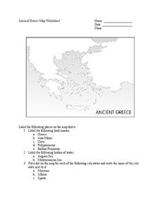
Ancient Greece Map Worksheet
Since the beginning of time, geography has shaped the development of human civilization, and ancient Greece is no exception. This worksheet supports young historians with exploring this relationship as they first identify key land...
PHET
Mapping the Field of Multiple Dipole Magnets
So you built a magnetometer, now what? High school scientists use their magnetometer made in a previous lesson to map the union of magnetic fields of dipole magnets. They experiment with different alignments and draw conclusions about...


