Mathematics Vision Project
Circles: A Geometric Perspective
Circles are the foundation of many geometric concepts and extensions - a point that is thoroughly driven home in this extensive unit. Fundamental properties of circles are investigated (including sector area, angle measure, and...
National Nanotechnology Infrastructure Network
What’s In Your Neighborhood?
Chart your way to an understanding of nanoscale. Using a Google map, learners estimate a radius around their location of 1,000 and 1,000,000 meters. Predicting what 1,000,000,000 meters would look like takes them off the charts!...
Curated OER
US City Quality of Life Analysis and Comparison
Students analyze US census data and criteria to compare and measure the quality of life in the country's fifty largest cities. After accessing the 2005 quality of life world report online, students conduct their study to compare three...
Curated OER
Evaluating an Illinois Earthquake
Students develop awareness of occurrences of earthquakes in Illinois and their past and potential future damage, and examine distribution of earthquakes in central U.S. regions.
Noyce Foundation
Photographs
Scaling needs to be picture perfect. Pupils use proportional reasoning to find the missing dimension of a photo. Class members determine the sizes of paper needed for two configurations of pictures in the short assessment task.
Oregon State
World Map of Plate Boundaries
Young geologists piece together the puzzle of plate tectonics in an earth science lesson. Given a physical map of the world, they search for land formations that indicate the location of different types of plate boundaries.
Association of American Geographers
Project GeoSTART
Investigate the fascinating, yet terrifying phenomenon of hurricanes from the safety of your classroom using this earth science unit. Focusing on developing young scientists' spacial thinking skills, these lessons engage...
Teaching Tolerance
Identity Self-Portraits
What symbols represent you best? Individuals consider how they would draw peers using symbols about their identities with an interview and art activity. After conducting interviews and portraits, the art makes a great centerpiece for...
Radford University
Earthquake Problem
Shake up things in the classroom. The unit uses earthquakes to bring a real-life connection to finding arc lengths, logarithms, and equations of circles. Small groups determine whether particular towns would have felt an earthquake after...
Curated OER
Geography With Dr. Seuss
Students read the book, The King's Stilts by Dr. Seuss and discuss the geographical information given in the book. Then they discuss and locate on a map the physical features that make up the continent of Africa. They create an original...
Curated OER
Measurement 4: Linear Measure
In this measurement worksheet, students use a ruler to measure, in inches, the distance of various line segments. Then, using the scale drawing, they determine the actual distance in miles. Students may use their knowledge of proportions...
Curated OER
How Much Water is in That River?
Students practice measurement using the Hudson River. They calculate the discharge measurement at a location on the Hudson River using ingenuity and a topographic map.
Curated OER
Mathematics of Cartography
Students practice their math skills as they explore maps. In this cartography lesson, students calculate distance, scale, coordinate systems, and projection as they work independently reading online maps.
Howard Hughes Medical Institute
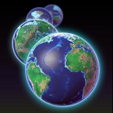
EarthViewer
Can you imagine Washington DC and London as close neighbors occupying the same continent? Learners will be fascinated as they step back in time and discover the evolution of the earth's continents and oceans from 4.5 billion...
Curated OER
To There And Back
Students calculate distance on a map by using a mileage scale to calculate the distance from their hometown to Niagara Falls. They, in groups, determine the best route, then compose stories about their journey to Niagra Falls.
Curated OER
Inches Away
Learners are introduced to maps, scale representations, ratios and cartography. They plot the itinerary for their family's dream vacation or a trip across the United States. Using maps, they determine the short route and second longer...
Curated OER
Draw A Coastline
Students identify, locate and draw at least ten different geographical features on a map. Using the map, they must make it to scale and include their own legend and compass rose. They share their map with the class and answer questions.
Curated OER
Home on the Range
Students use maps and mathematics to determine the appropriate panther population in a given area. In this Florida ecology lesson, students research the area requirements of male and female panther and use a map to help calculate how...
Curated OER
Freeform Texas Map
In this Texas map worksheet, students research, label and discuss the most important cities in Texas, its physical attributes and the states that surround Texas.
Curated OER
Freeform Pennsylvania Map
In this Pennsylvania map worksheet, students research, study and label twenty important cities, physical attributes and the neighbors that surround Pennsylvania on a Pennsylvania map.
Curated OER
U.S. Geography- The Northeast
Students investigate the geography of the Northeast states. In this map skills lesson, students are shown a map of the Northeast states and identify the state names and borders. Students construct individual maps of the Northeast using...
Curated OER
Globe Skills Lesson 4 The Colonial Period
Middle schoolers practice their map skills. In this Colonial geography lesson, students complete an activity that requires them to locate English colonial locations using latitude and longitude coordinates.
Curated OER
Message in a Bottle
Sixth graders write a short story about being stranded on a deserted island. After a brief geography review of locations at various latitudes and longitudes, 6th graders draft their story about being stranded. They use sensory and...
Curated OER
Getting to the Core of World and State Geography
Students create topography relief maps. In this geography skills lesson, students review geography core knowledge skills, design and make a state relief map, and compile a student atlas.
Other popular searches
- Using Map Scale Distance
- Proportions Using Map Scale
- Using Scale on Maps
- Maps Using Scale
- Using a Scale Map


