Curated OER
The Geography of the United States
Full of bright maps and interesting information, this presentation details U.S. Geography. Slides include basic facts about size, regions, topography, and demographics, as well as fascinating trivia about the United States, including...
Curated OER
United States: Physical Features Fun
In this map worksheet, students color and trace eleven listed features on a map of the United States. Students answer six additional questions about the map. A United States map is not provided. However, websites are provided to find...
West Virginia Department of Education
A State of Convenience: The Creation of West Virginia
Ever wondered why there is a West Virginia but not an East Virginia? The resource answers questions like this one and more as it takes an in-depth and detailed look at the history of West Virginia and how it became a state. Several...
Curated OER
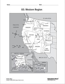
US: Western Region Map
In this United States Western Region worksheet, students examine the state boundaries and landforms found in this region. The map also highlights each of the state capitals.
National Geographic
Mapping the Americas
Celebrate the geography of the Americas and develop map skills through a series of activities focused on the Western Hemisphere. Learners study everything from earthquakes and volcanoes of the Americas and the relationship...
Curated OER
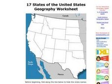
17 states
In this states learning exercise, students label states in the United States that are on the west side of the country. Students label 17 states.
Curated OER
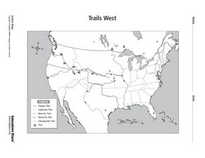
Trails West: Westward Expansion Maps
In this United States historical map worksheet, learners examine the trails that settlers of the Western United States took during the period of Western Expansion. Major cities on the routes are labeled.
Curated OER
Utah: State History
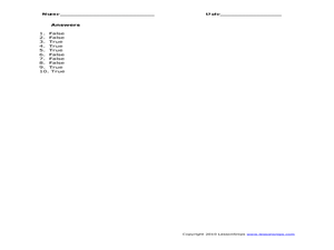
For this Utah state history worksheet, students read two and a half pages of information about Utah and complete 10 true and false questions.
Curated OER
Spanish Influence in the U.S.
Eighth graders research the role of the first Spanish conquistadors who explored the now United States. Using the internet, they gather information on different explorers and write a paper about why he is important in American history. ...
Annenberg Foundation
Contested Territories
United States expansion into Western territories impacted much more than just lines on a map. The seventh installment of a 22-part series about America's history puts scholars into the lives of those making the journey westward as well...
Curated OER
States and Capitals, Mountains and Rivers
Learners identify geographical locations in the midwestern United States. In this geography lesson plan, students identify 12 states and capitals and geographical features in the region by using U.S. maps. Learners use blank maps to fill...
Curated OER
Song Mapping
Students explore locations on the United States map. In this map skills lesson, students recite the song This Land Is Your Land and locate various places listed in the song on the map.
Curated OER
Trails West Map
In this United States historical map worksheet, students examine the trails that settlers of the Western United States took during the period of Western Expansion.
Curated OER
The Brief American Pageant: The Confederation and the Constitution
Four maps cover the tumultuous period during and after the American Revolution. Especially interesting is the first map, which details the land cessions to the United States after 1782. Think about incorporating these pictures into your...
Curated OER
California's Golden History: 1848-1880
Using a variety of online resources, learners study life and society in California during the gold rush. They use a map to identify area where gold was located, explore pre-selected websites, describe mining practices, and create an...
Curated OER
Mapping the Changes
Students research an aspect of life of their choosing of a western state either before the Civil War, after the war or today. They are to write about the aspect they choose and make illustrations.
Curated OER
Find a Cave
Learners locate their own communites and the nearest caves on a United States map. They calculate the distance to the nearest cave using rough scale.
Curated OER
Farming Idaho
Students use a digital atlas to explore areas in the Western United States that depend heavily upon water. They explore the type of soil and the farming that is compatible with the soil. As a class, students explore Idaho's economic...
Curated OER
Plotting a Hurricane Using Latitude and Longitude
Learners define and use "absolute location," latitude, and longitude. They locate on a map or globe the Earth's poles, circles, tropics, and beginning points of measurements for latitude and longitude.
Curated OER
Sectionalism
Learners examine sectionalism. In this sectionalism activity, students explore reasons sectionalism developed. Learners realize the conflicts that led to the Civil War and how sectionalism affected citizens on the border of Kansas...
Curated OER
Build a U.S. Strategy for Responding to the Crisis in Sudan
Students work together in groups to discover the situation in Sudan. They discuss what problems arise from helping a foreign country. They answer questions and watch a video as well.
Bismarck Public Schools
Chapter 9 Review WKST
Here is a traditional multiple-choice, true/false, and fill-in-the-blank assessment on the presidency of James Monroe in the United States. It was designed to supplement a particular textbook chapter, but could be used to assess learning...
Curated OER
Getting to the Core of World and State Geography
Students create topography relief maps. In this geography skills lesson, students review geography core knowledge skills, design and make a state relief map, and compile a student atlas.
California Polytechnic State University
Australian Geography Unit
At the heart of this resource is a beautifully detailed PowerPoint presentation (provided in PDF form) on the overall physical geography of Australia, basic facts about the country, Aboriginal history, and Australia culture and lifestyle.


