Curated OER
Of Maps and Worldviews
Students explore Ptolemy's world map as an expression of the Renaissance view of the world.
Curated OER
World Geography: Smart Cities
Students are able to analyze how a variety of cities both in the USA and abroad have worked to improve human health and environment. They combine their prior knowledge of previous lessons and apply that knowledge to compare how each...
Curated OER
World Geography: Climate Change Round Table
Young scholars are able to explain the suspected causes of relatively recent climate changes, specifically the observed global warming. They discuss how unusual or extreme global warming disrupts the balance of the earth's geo-spheres.
Curated OER
World Map and Globe - Lesson 1 Introduction to the Globe
Students explore the earth with maps and globes. For this map lesson, students use maps and globes to locate oceans and continents.
Curated OER
Where in the World War? Mapping WWII in the Pacific
Students study the geography of the Pacific theater of World War II. They study maps to examine the geography and features of the land.
Curated OER
World Geography: Postcard from the Rim
Students are able to identify the areas of the world that are affected by arsenic contamination of the water supply. They are able to describe the ways in which various societies deal with the problem of arsenic contamination. ...
Curated OER
Explore Your World--Geography Takes You Places
Students examine how the world around them is constantly changing. In groups, they travel between centers in their classroom to role play the role of explorers in Washington D.C. They share their experiences with their classmates and...
Curated OER
World Religions
Seventh graders identify major tenets and the distributions of world religions. In this world religions lesson, 7th graders work with a group to research a religion using the given website. Students complete a graphic organizer for the...
Curated OER
World Religions
Students identify the major beliefs, the founders, and the origin for the five major world religions-Hinduism, Buddhism, Christianity, Islam, and Judaism. They identify, on a world map, the regions and countries these religions are...
Curated OER
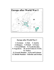
Europe after World War I
In this Europe after World War I map worksheet, young scholars note the 11 regions of the Europe labeled on the map.
Curated OER
Geography: Water, Water Everywhere
Students discuss flooding and its causes. They view a Powerpoint presentation about floods and prevention methods. After creating a model with clay and pans, they investigate river behavior in various terrains with different amounts of...
Population Connection
The Carbon Crunch
Carbon is in the air; should we care? Teach the class why it is important to pay attention to carbon levels and how the world population and various countries across the globe affect the carbon levels in the atmosphere. High schoolers...
Facing History and Ourselves
Identity and Place
Build scholars' ability to understand their own values and learn about World War II at the same time. Scholars write poetry and discuss identity and place in depth with an in-depth social studies resource.
Curated OER
The Hispanic World
Go on an electronic field trip. Discover Spanish-speaking countries through Internet exploration. Students participate in a whole group discussion to general knowledge about the location, cultural background, independence and current...
Microsoft
Coordinates
What are your coordinates? After learning about coordinate systems in the real world, scholars see how a three-dimensional coordinate system works in Minecraft. They write a program to produce a compass rose and conduct an activity where...
Curated OER
Will There Be Subsistence Farmers in the 21st Century?: Feeding the World
Students examine the topic of subsistence farming. They research the future of subsistence agriculture, identify the types and locations of subsistence agriculture, and write about subsistence farming in regards to developing nations and...
Curated OER
A world of oil
Students practice in analyzing spatial data in maps and graphic presentations while studying the distribution of fossil fuel resources. They study, analyze, and map the distribution of fossil fuels on blank maps. Students discuss gas...
Peace Corps
Celebrating Our Connections Through Water
Water is vital for survival, but how does it help global cultures flourish? Elementary and middle schoolers learn about the different cultures around the world that celebrate water and incorporate it into their festivals or traditions.
National Museum of the American Indian
The A:Shiwi (Zuni) People: A Study in Environment, Adaptation, and Agricultural Practices
Discover the connection of native peoples to their natural world, including cultural and agricultural practices, by studying the Zuni people of the American Southwest. This instructional activity includes examining a poster's...
Curated OER
The Big Circle
Students explore geography by participating in a mapping activity. In this concentric ring lesson, students utilize a poster board, string and markers to identify their current location within the entire world. Students write about their...
Curated OER
MAISA and the REMC Association of Michigan
Students complete online research to study geography's impact on weather. In this geography and weather lesson, students research weather in their city for ten days using an online website. Students bookmark the site, enter data into a...
Curated OER
Roman Empire: Physical Framework - Location, Borders, Dimensions
Students relate the classical world to the modern world. For this map skills lesson, students turn a blank map into a colorful complete map by following step-by-step directions. This lesson allows students to connect our current...
Curated OER
Police Action: The Korean War, 1950-1953
Students explore why the United States became involved in the war in Korea. They discuss the confict between Truman and MacArthur, culminating in the latter's dismissal from command. They identify on a world map foreign countires...
Curated OER
Everybody Cooks Rice
Students read the book, "Everybody Cooks Rice," and they participate in activities pertaining to the book. They identify countries mentioned in the text and locate them on a world map. They use an atlas to identify the climatic...
Other popular searches
- World War I Map
- Mapping Penny's World
- Map of the World
- World Outline Maps
- Blank Maps of World
- World War 2 Map
- World War 1 Maps
- World War I Outline Map
- Map of World
- World Climate Map
- Blank World Outline Maps
- World Biomes Map


