American Battlefield Trust
Pre-1860: Disunion
Using personas ranging from freed African Americans to wealthy plantation owners, young historians consider various points of view around the events in the days leading up to the Civil War including major milestones such as the Dred...
American Battlefield Trust
Contrasting the North and South Before the War
Fundamental differences between the North and South led to the South adopting a system of enslaved labor. These abstract ideas become concrete when class members create a standing cube using information provided in the resource. Young...
Mathed Up!
Bearings
Keep the math straight and true. Using information learned about angle relationships, pupils determine drawn bearings, or draw a line with a given bearing. The accompanying video provides the definition of a bearing and its three...
Civil War Trust
Contrasting the North and South before the War
Learners create a standing cube with four panels that display information on the North and South's economy, geography and climate, society, and means of transportation before the Civil War. Through discussion and reading...
Curated OER
Chapter 3 Test: Civil War
Although specific to a certain book, this test and review relating to the Civil War could used in any classroom. The questions asked are appropriate for students learning about this era in U.S. History. Questions could be altered, or...
Curated OER
Pirate Treasure Hunt
First graders name the directions North, South, East, and West on a map. They work collaboratively in small groups and create a treasure map using directions as clues.
Curated OER
Orienteering Scavenger Hunt Lesson Plan: Middle School
First, teach your class how to read a compass, and then do the scavenger hunt. This is rather a nice little activity to do. It can be done as part of a unit on orienteering or just for the fun of it as a stand-alone lesson. The fun...
Curated OER
U.S. History Worksheet #72
Why did the North win the war? In this United States history worksheet, students utilize a word bank of 10 terms or phrases to answer 10 fill in the blank questions pertaining to the Civil War. A short answer question is included as...
Curated OER
Create a Migrant's Scrapbook from the First Great Migration
Help young historians personally engage in the stories of African Americans during the Great Migration! Assessing a migration route map, learners create a migrant character's experience, adding details while studying primary sources. A...
Curated OER
What Were the Political & Social Views of People During the Civil War
Eighth graders study the Civil War. In this US history lesson, 8th graders discuss the causes for fighting for the North and the South showing that there was no good side or evil side just people believing in what they were fighting for....
Curated OER
Cardinal Directions
First graders study cardinal directions on maps. In this geography lesson, 1st graders determine and show where North, South, East, and West are on various maps.
Curated OER
Civil War
Students are be able to analyze primary sources (Civil War images) for examples of how soldiers are portrayed historically. They discuss what a hero is and why some individuals are heroes to certain groups while others are not.
Curated OER
The Great Migration: Pushed By The South, Pulled By The North
Students identify key features of the Great Migration. They explain the concepts of push and pull factors for migration. They create an art project which shows an understanding of the push and pull factors.
Curated OER
All About the Animals
Whose footprints are those? After reading Janet Halfmann's book, Little Skink's Tail, young scholars use footprints to determine where on a gridded map certain animals have been spotted. They use the map to answer 3 questions, one...
Curated OER
Free Blacks in the North and in the South
Eleventh graders research the different lives of free blacks in the South and the North. In this Post Civil War instructional activity, 11th graders analyze primary sources that illustrate their lives. Students create posters that...
Curated OER
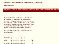
A Walk in Winchester
In this Winchester worksheet, students determine the number of different routes to a determined location. This one-page worksheet contains 1 problem. The answer is provided at the bottom of the page.
Curated OER
Four Main Directions
Young scholars describe directions using a globe for north, east, south and west. For this mapping lesson students identify the north and south pole. Young scholars understand the importance of the equator and the Prime Meridian....
Curated OER
Latitude Longitude
In this latitude and longitude worksheet, students place a dot on a graph that represents each latitude and longitude location given. The worksheet has 46 locations to graph.
Curated OER
Latitude Longitude
In this latitude and longitude worksheet, learners plot 39 latitude/longitude locations on a graph, connecting the dots as they go along.
Curated OER
Latitude Longitude
In this latitude and longitude worksheet, students plot 34 latitude/longitude locations onto a graph, connecting the dots as they go along.
Curated OER
Writing Vectors
In this vectors worksheet, students draw 15 vectors using a given key with direction and measurement. Students are given a specific distance and direction for each vector to draw.
Curated OER
VS.7a
Seventh graders explore, analyze and identify the events and differences between northern and southern states that divided Virginians and led to secession, war and the creation on West Virginia. They discuss the conflicts that developed...
Curated OER
The Economic Differences Between the North and the South Prior to the Civil War
Seventh graders identify and explain the economic differences between the North and the South incorporating photographs and a Venn Diagram to interpret the two sides. They complete a KWL and T-chart to assist them with their task for the...
Curated OER
Delightful Directions
First graders identify and demonstrate how symbols and models are used to represent features of the environment. They identify the directions on a map as east, west, north, and south. Finally, 1st graders play a direction game, move to...


