National Wildlife Federation
Sensory Discovery Walk
Let your senses be your lead. Pairs of pupils blindfold their partners and then lead them around nature areas. They use their senses to find landmarks and create maps with their findings. Once they create their maps, they go back to the...
Environmental Education in Wisconsin
Biome Travel Guide
In a perfect marriage of social studies and science, groups work together to research and create a travel guide presentation to share with the class. Not only do kids learn about the climate and geography of a biome, but also the...
Curated OER
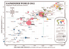
Gapminder World 2012
Here is a very interesting infographic that compares the average life expectancies, per capita incomes, and population sizes of every country in the world in 2012.
Channel Islands Film
Arlington Springs Man: Lesson Plan 4
West of the West's documentary Arlington Springs Man introduces viewers to the remarkable finds on Santa Rosa Island. Archaeologist have discovered on this small island that is part of the Channel island chain, human and pygmy mammoth...
College Board
2003 AP® Human Geography Free-Response Questions
What role has tourism played in changing the landscape of a country? How do human migration patterns affect a nation? To what extent can urban development patterns help us understand our cities? Learners explore these ideas and more...
Curated OER
Yo Ho, Yo Ho, A Pirate's Map for Me: An Original Story
Students read Blackbeard and brainstorm their knowledge of maps. For this language arts and geography lesson, students use landmarks on their playground to review north, south, east and west and discuss the compass rose. Students read...
Curated OER
Latitude and Longitude: Geography and Geometry!
Second graders use latitude and longitude coordinates to pinpoint an exact location on the map. In this geography instructional activity, 2nd graders utilize handouts from the Maritime Museum in order to gain practice in finding...
Curated OER
Mapping Roxaboxen
Fourth graders read Roxaboxen and draw a map of the Roxaboxen community. In this language arts and geography lesson, 4th graders use specifications given, adding features to the map as described in the book and creating a legend.
Curated OER
What do Maps Show?
Eighth graders practice the skill of reading maps. In this geography lesson, 8th graders participate in a classroom lecture on how to read a map.
Curated OER
Europe Map
In this world geography activity, students study the map of Europe and locate the 48 countries within the continent. Students write the names on the provided lines.
Curated OER
Maps, Charts, and Graphs
Students define key geographic terms and track a hurricane on a map. They examine various types of maps and find locations on them,including rivers, cities and mountains.
Curated OER
North America Outline Map
In this blank North America outline map worksheet, students study the political boundaries of the continent. This outline map may be used for a variety of geographic activities.
Curated OER
World Map and Globe - Four Main Directions
Students study the four main directions on a map. In this map lesson, students locate the North and South pole, and learn the four cardinal directions. They use the compass rose on a map to help with the directions. (Map is not included...
Curated OER
Old World and New World - Why Contact Took So Long
Students use a globe to determine why contact between the old world and the new world took a long time. In this map skills lesson, students analyze routes between regions to determine why it took so long for the old world and the new...
Curated OER
Geography and Culture
Students explore African geography, study the overall continent of Africa and its individual countries, discuss demographics, and participate in research and class activities.
Curated OER
Geography of China (Tibet)
Sixth graders study the geography of Tibet. They create maps of Tibet. Students predict population, land area, water area and coastline length of the United States and Tibet. Students compare and contrast the day-to-day lives of people...
Curated OER
Mapping Your Way Around
First graders identify a map, symbols on a map, and locate places on a map. Finally, they construct a map
Curated OER
Explore Surface Types on a Journey Around Earth
Students explore satellite data. In this technology cross-curriculum math and world geography lesson plan, students locate specific map areas using a microset of satellite data. Students use technology and math skills to determine...
Curated OER
You Can Find It!
Students, in groups, use longitude and latitude to locate various places on a map.
Curated OER
Cartographer on Assignment: Creating a Physical Map of Africa
Students use geographic information to make an outline map of Africa, then demonstrate their understanding of the physical landscape of Africa by using a variety of materials to create a physical map of Africa
Curated OER
The Geography - Writing Connection
Pupils examine and describe the four physical systems of the Earth. Using two of the systems, they practice their writing skills and use vocabulary associated with the different types of landforms. They predict the types of shelters are...
Curated OER
Things That Stick Out Or: How To Find Your Way Around on a Map
Learners explain the meaning of and recognize the map outlines of a peninsula, an isthmus, and a cape.
Curated OER
Where Am I?
Students identify volcano locations by latitude and longitude. They analyze a world map, and complete a "Volcano Event Locations Chart."
Alabama Department of Archives and History
La Mobile: A Case Study of Exploration and Settlement
The Le Moyne brothers, Jean-Baptiste and Pierre, were among the first explorers of the Gulf Coast. Class members read biographical information and journal entries about these men, study maps showing where the settlements they established...
Other popular searches
- Geography Map Skills Scale
- Geography Map Skills Europe
- Usa Geography Map Skills
- Geography Map Skills Us
- Canada Geography Map Skills
- Map Skills Geography Themes
- Geography Map Skills Ohio
- Map Skills Geography


