New York State Education Department
US History and Government Examination: August 2010
Geography has played a complex role in America history. The Atlantic Ocean has served as a buffer to protect the United States from European Wars, but its proximity to Cuba, however, left it vulnerable to nuclear war during the Cuban...
Indian Land Tenure Foundation
Maps and Homelands
You are never too young to learn about maps. To better understand the concept of a homeland, students work together to construct a map of their local area out of paper puzzle pieces. They'll put the maps together and then add details by...
Curated OER
United States Map
Students access prior knowledge and locate the North and South Poles on the map. In this mapping lesson plan, students understand the position of the United States relative to the poles. Students answer questions about the globe.
Curated OER
Denali Park Topographic Maps
Young scholars construct a topographic map of the Denali National Park. They identify different elevations and record historic landmarks in student science journals.
Curated OER
Assessing and Making Maps
Students evaluate maps using the TODALSIGs basic map analysis system, explained on the worksheet. They create a map of Alaska using TODALSIGs. Students brainstorm the elements of maps.
Curated OER
Westward Expansion : Mapping
Fifth graders travel along exploring the expeditions of John F. Fremont. In this Westward expansion lesson, 5th graders gain understanding of the events that shaped the west through the use of maps. Students use mapping skills to...
Curated OER
Drawing Conclusions - Is This a Map of the Underground Railroad?
Students complete activities to study potential maps of the Underground Railroad. In this Underground Railroad lesson, students watch a video about map collector Anne Zorela's Underground Railroad map. Students complete a graphic...
Curated OER
Cause And Effect Map
For this Language Arts worksheet, students create a cause and effect map. Students describe three causes, one event or situation, and three effects.
Curated OER
Sequencing Map
In this Language Arts worksheet, students create a sequencing map of a story or book. Students describe six scenes or ideas from their book that happen in a chain of events.
Curated OER
Acadiana Map (Map of Acadians in Louisiana) PowerPoint Slide
Is your class studying the state of Louisiana? This slide provides a good visual of Acadiana Louisiana, or as it is otherwise known; the Historic Cajun Country. The 22 parishes that make up this French-influenced region are numbered on...
Curated OER
Texas Commemorative Maps: Honoring Our Past
To celebrate Texas, groups plan and create a commemorative map for a topic or theme in Texas history. The richly detailed plan and the approach could easily be adapted to any state. Samples are included.
Teach Engineering
Where Are the Plastics Near Me? (Mapping the Data)
The last activity in a nine-part series has teams create a Google Earth map using the data they collected during a field trip. Using the map, groups analyze the results and make adjustments to the map to reflect their analysis. A short...
Statistics Education Web
What Percent of the Continental US is Within One Mile of a Road?
There are places in the US where a road cannot be found for miles! The lesson plan asks learners to use random longitude and latitude coordinates within the US to collect data. They then determine the sample proportion and confidence...
Curated OER
Map that Habitat
Students participate in an activity that replicates the creation of sea floor bathymetry by taking a simplified form of soundings in the classroom. They discuss sea floor mapping technologies, sonar, soundings, and remote sensing,...
Smithsonian Institution
Borders with the World: Mexican-American War and U.S. Southern Borderlands
The Mexican-American War created social borders—not just physical ones. Scholars learn about the effects of the Mexican-American War on the people living in the borderlands using text excerpts, maps, and partnered activities. Academics...
Curated OER
Map-A-Buddy
Students investigate the concept of tracking and spatial movements of animals in relation to the environment in which they live. They participate in an interactive activity by tracking one another over a pre-defined region, record the...
CK-12 Foundation
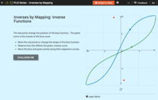
Inverses by Mapping: Inverse Functions
Map your way to successfully understanding inverse functions. Pupils use an interactive map to investigate how changes in the graph of a function affect the graph of its inverse. The results of the activity lead to the conclusion that...
CK-12 Foundation
Whole Number Multiplication: Multiplication Map
How many miles did a car travel if it traveled at 55mph for three hours? What are the factors for this multiplication sentence? These are the questions young mathematicians must solve using a multiplication map.
Curated OER
Making Maps
In this map making worksheet, students learn about the science of making maps, which is cartography. They then answer the 11 questions on the worksheet. The answers are on the last page.
Curated OER
U.S. Political Map
Students explore the symbols found in a map legend. In this map skills lesson, students locate the legend on a political map and explain what each of the symbols mean. Students locate and identify several symbols on the map.
Curated OER
Map Reading in the 21st Century
Students interact with MapPoint tools to view maps of the past and the present in multiple ways. They participate in mini-lessons aimed at locating certain points of interest or famous routes taken in history.
Curated OER
Introduction to the United States Map
Students identify a map of the United States. In this United States map instructional activity, students study a map of the United States and find various locations on the map. Students then locate and list the state that touches their...
Curated OER
United States Map
Young scholars describe cities they are familiar with. In this United States Map lesson, students understand how cities are listed on a map. Young scholars become aware of a map legend and the information in it.
Curated OER
Blank US Map
In this blank outline map activity, students study the physical boundaries of the 50 states that make the United States. This outline map may be used for a variety of geographic activities.
Other popular searches
- Us Map 13 Colonies
- Using a Map Key
- Using a Map Scale
- Ussr Blank Map
- Us Map
- Map Uses
- Ussr Map
- Us Imperialism Map Activity
- Using Map Scales
- Using Map Scale Distance
- Us Map Skills
- Usa Geography Map Skills


