Curated OER
North America Map
In this North America political map activity, students examine the labeled countries and their respective national boundaries.
Curated OER
North America: Unlabelled Map
In this North America political map instructional activity, students examine the unlabelled countries and their respective national boundaries.
Curated OER
Story map
In this story map activity, students fill in a story map that contains the elements of conflict in a story. Students answer the questions of who, what, and why.
Curated OER
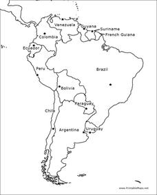
South America Outline Map
For this outline map worksheet, students discover and investigate the physical boundaries of the countries in South America. The names of countries and a star to mark the capital city are included.
Curated OER
Australia Map
In this Australia outline map worksheet, students make note of the political divisions of the 5 provinces and territories of the nation.
Curated OER
Map Reading
In this reading maps practice instructional activity, learners respond to 16 questions that require them to determine the directions north,, south, east, and, west.
Curated OER
Mapping Skills
In this mapping skills worksheet, students practice scale measurements as they respond to 8 questions that require them to measure to scale.
Curated OER
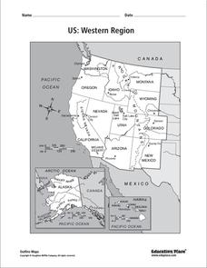
US: Western Region Map
In this United States Western Region learning exercise, students examine the state boundaries and landforms found in this region. The map also highlights each of the state capitals.
Curated OER
Examining Character Traits through Character Mapping
Some of what we know about a character is directly stated. Some of what we know is inferred by events in the story. Character maps help primary learners recognize the difference. After modeling with a story your class has read, pupils...
Curated OER
Homeostasis and Transport Concept Map
In this biology worksheet, students complete a concept map on cellular transport. They fill in 11 blanks with the correct terminology from the given list.
Curated OER
Sponges, Cnidarians and Worms Concept Map
For this sponges, cnidarians and worms worksheet, learners complete a concept map on simple invertebrates. They fill in 11 blanks with the correct answers from the list.
Curated OER
The Crimean War
Use the list of cities, countries, and water ways to correctly label a map of the regions associated with the Crimean War. There are approximately 20 locations to locate and identify.
Rainforest Alliance
Knowing the Essential Elements of a Habitat
To gain insight into the many different types of habitats, individuals must first get to know their own. Here, scholars explore their school environment, draw a map, compare and contrast their surroundings to larger ones. They then...
Curated OER
Designing a Hiking Trail
Put your students' map skills to the test with this engaging cross-curricular project. Given the task of developing new hiking trails for their local community, young cartographers must map out beginner and intermediate...
BrainPOP
Latitude and Longitude Differentiated Lesson Plan
Scholars warm-up their map skills with a discussion using location words to describe familiar places. An engaging video informs class members about latitude and longitude. Three leveled activities extend the learning experience for...
Curated OER
Understanding Protagonists and Antagonists
How can you tell if a character is a villain? What about a hero? Work on literary analysis with an engaging language arts worksheet. After completing an activity about the four types of conflict, learners fill out a character map about a...
Teach Engineering
What is GIS?
Is GIS the real manifestation of Harry Potter's Marauders Map? Introduce your class to the history of geographic information systems (GIS), the technology that allows for easy use of spatial information, with a resource that teaches...
It's About Time
Volcanic Landforms
Did you know the word volcano comes from the name of the Roman god of fire, Vulcan? During this activity, scholars make a topographic map, interpret topographic maps, and infer how lava will flow based on their analysis.
Columbus City Schools
Constructive and Destructive Geologic Processes
Show the class the world as they've never seen it before—from way above! Learners try to unravel the mysteries presented by rich satellite imagery, learn to interpret topographic maps, and study erosion by constructing their very...
NET Foundation for Television
1850-1874 Homestead Act Signed: The Challenges of The Plains
Start a whole new life in a land known as the Wild Wild West! Learners analyze maps, personal accounts, the Kansas-Nebraska Act, songs, and video clips to uncover life under the Homestead Act. Using their new skills, class members role...
Teaching Oasis
Gingerbread Baby Lesson Plan Guide
Reinforce reading comprehension and story mapping skills with the help from a story, Gingerbread Baby by Jen Brett. Individuals discover new vocabulary, make predictions, retell main events, respond to reading using a graphic...
Newspaper Association of America
Community Connections with Geography and the Newspaper
Understanding geography and government begins at the local level. Using maps and the parts of a newspaper, a unit plan introduces the concept of community. It starts with the creation of classroom and school maps, and then moves through...
Curated OER
Rhode Island Map
For this recognizing the shape of the state of Rhode Island worksheet, students fill in the state capital, major cities, and other attractions or follow their teacher made directions. Students write at least 7 answers.
CK-12 Foundation
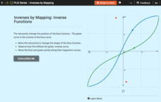
Inverses by Mapping: Inverse Functions
Map your way to successfully understanding inverse functions. Pupils use an interactive map to investigate how changes in the graph of a function affect the graph of its inverse. The results of the activity lead to the conclusion that...
Other popular searches
- United States Maps
- Weather Maps
- Topographic Maps
- Story Maps
- Maps and Charts
- Types of Maps
- Maps and Globes
- Middle East Maps
- Maps and Flags
- Historical Maps
- Maps of Europe
- Create Character Maps


