Curated OER
Transporting Coal
Some really interesting worksheets on Amtrak's national routes, and the major river systems of the United States accompany this lesson on the transportation of coal throught the country. This is an exceptionally well-designed lesson that...
Curated OER
Effects of Urban Growth
Learners explore population growth in the United States and the impact it has had on society. First, they brainstorm the reasons for population growth and the results of these increases. Then, they design surveys, record results, and...
Curated OER
Water Features - Lesson 2 - U.S. Political Map Grade 4-5
Students locate water features on maps. In this geography lesson plan, students complete worksheets that require them to identify water features on a U. S. political map.
Curated OER
Learning About Maps
Students investigate the many uses and features of maps and globes and locate where they live on both. In this map lesson, student play a travel game and create their own maps to explore states, continents, countries, and islands.
Curated OER
U.S. Political Map
Students explore the symbols found in a map legend. In this map skills instructional activity, students locate the legend on a political map and explain what each of the symbols mean. Students locate and identify several symbols on the map.
Curated OER
Holocaust Map Studies
Students analyze maps and answer discussion questions related to WWI. In this geography lesson, students analyze historic maps to determine causes and effects of WWI in Europe. Students read testimonies of Holocaust survivors and label...
Curated OER
States and Capitals - Lesson 4 - U.S. Political Map
In this U.S. state capitals worksheet, students identify the capital cities of the 50 states using the latitude and longitude coordinates provided.
Curated OER
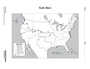
Trails West Map
In this United States historical map worksheet, students examine the trails that settlers of the Western United States took during the period of Western Expansion.
Curated OER
History Close to Home
Students examine primary sources as related to Nevada and the Civil War. In this United States history lesson, students gather and analyze various primary sources in small groups and interpret unknown vocabulary words by using context...
Curated OER
Colonial America 1776 Map
In this United States historical map learning exercise, students examine the colonial boundaries in 1776 as well as the Proclamation Line of 1763.
Curated OER
The 13 British Colonies Map
In this United States historical map worksheet, students examine the 13 colonial boundaries and noted major cities.
Curated OER
Rockin' Round New York State
Students discuss their favorite rock groups and bands. They create rock groups that will be touring New York State. Students research cities in New York, determine dates of concerts, create touring itineraries, and develop Inspiration...
Curated OER
Ancient Greece and Ancient Rome Unit Plan
Students make two T charts, one for Sparta and one for Athens, showing pros and cons for living in either city-state. They use the physical information from the map and the cultural captions given for Athens and Sparts to come to their...
Teach Engineering
Where Are the Plastics Near Me? (Mapping the Data)
The last activity in a nine-part series has teams create a Google Earth map using the data they collected during a field trip. Using the map, groups analyze the results and make adjustments to the map to reflect their analysis. A short...
Curated OER
Making a Report to President Washington
Young scholars gain an understanding of some of the challenges the U.S. faced at its birth. They are asked to compose a report on the state of the nation in 1790 (addressed to President George Washington), which includes a narrative,...
Curated OER
Arkansas State Rock
Here is a lesson plan which shows the value of a mineral called bauxite to Arkansas during the early 1900's. Learners relate the five themes of geography to the history of bauxite and aluminum production in Arkansas. For teachers of...
Curated OER
Map-A-Buddy
Learners investigate the concept of tracking and spatial movements of animals in relation to the environment in which they live. They participate in an interactive activity by tracking one another over a pre-defined region, record the...
Curated OER
Let the Music Play: Bicentennial quarter reverse
To better understand who George Washington was and why we celebrated the bicentennial, pupils read a story and complete a worksheet. They sing and talk about the song, "Yankee Doodle Dandy" as they march around the room.
Annenberg Foundation
A Nation Divided
Can a presidential election cause a civil war? Learners research the events surrounding the presidential election of 1860 in a lesson that explores America's history. Using maps, videos, and primary sources, they uncover, brainstorm, and...
Theodore Roosevelt Association
Roosevelt's Legacy: Conservation
The legacy of Theodore Roosevelt carries through modern American politics, economics, foreign policy, and society. But his proudest and most profound efforts were in the world of conservation, and in preserving the natural beauty of...
Ashbrook Center at Ashland University
Federalist - Antifederalist Debates
Who should have the power—individual states or the federal government? Scholars research the arguments of the Federalists and Anti-Federalists during the formation of the United States Constitution. Online resources, including a vast...
National Endowment for the Humanities
“The Great Migration” by Minnie Bruce Pratt
Minnie Bruce Pratt's poem, "The Great Migration," offers young scholars an opportunity to reflect on how where we come from influences who we are. Groups conduct a close reading of the poem, recording observations about the poem's...
Curated OER
The American War for Independence
Students complete a unit of lessons that examine the goals of the Americans during the Revolutionary War. They explore an online interactive map of major campaigns, read and analyze primary source documents, and analyze diplomatic and...
K20 LEARN
Of Mice and Men in the Great Depression: Background and Setting
What were living conditions like in the United States during The Great Depression, and how do those conditions compare with today? That's the question young scholars consider as they prepare to read John Steinbeck's Of Mice and Men....
Other popular searches
- United States Maps
- United States Maps Regions
- Northeast United States Maps
- 50 United States Maps
- Create United States Maps
- Western United States Maps
- Custom United States Maps
- Outline Maps United States
- Blank United States Maps
- United States Landforms Maps
- United States Geography Maps
- United States Political Maps


