Curated OER
From the Heights to the Depths
Students create a relief map of Asia and Australia. They work in small groups on sections of the map to make one complete map of the continents.
Curated OER
What Is El Niño?
Students access information at remote sites using telecommunications, identify impacts by reviewing past El Ni??o events, make and use scale drawings, maps, and maps symbols to find locations and describe relationships.
Mathematics Vision Project
Circles: A Geometric Perspective
Circles are the foundation of many geometric concepts and extensions - a point that is thoroughly driven home in this extensive unit. Fundamental properties of circles are investigated (including sector area, angle measure, and...
Curated OER
The Mathematics of Space and Place
Students investigate the measurements and geometry of the school grounds. They conduct inquiry while measuring the campus and some of the city blocks. Then students draw a map to scale and categorize property types using a pie graph.
Curated OER
Interior of the Earth
Sixth graders identify and describe the composition and physical properties of the layers of the Earth. They also explain how scientists used the scientific process to know about the center of the Earth. Finally, 6th graders read a...
Curated OER
Colonial Vacation Planner
Pupils plan a family vacation to states that were among the original 13 colonies. The groups determine which state they visit, map their route, calculate the mileage, and determine how much money they spend on gasoline.
Curated OER
The Sustainable Olympics
In this sustainable Olympics worksheet, students utilize a large map of the British Isles, map scale a long piece of string to calculate the approximate distance between their school and 8 locations where some of the Olympic events may...
Curated OER
Where in the World Am I: Latitude And Longitude
Students demonstrate their knowledge in using latitude and longitude measurements to find locations on a map, especially places in Hawaii.
Curated OER
Mapping a Stream
Students map an actual local waterway. They create full color scale drawings that include windfalls, plant cover, streambed composition, and landmarks such as trees, boulders, and slumps. This is a long-term project that involves...
Curated OER
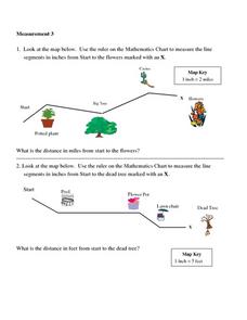
Measurement 3: Rulers
In this measurement worksheet, students measure the linear distance, in inches, between stated objects. Next, they determine the actual distance, in miles.
Curated OER
Tour of the World
For this tour of the world puzzle, students read a map and determine a travel itinerary based upon given criteria. They are required to visit 23 cities. This one-page worksheet contains one puzzle. The answer is provided at the bottom...
Curated OER
Congressional Travel
Students determine the distances traveled by the members of the legislative branch of the US Government. In this travel distance instructional activity, students locate Washington, DC on a globe using the longitude and latitude of the...
Curated OER
Scale Basketball
Students discuss scale diagrams and maps as well as the use of spreadsheets to find the best scale to use in a model before practicing scale and ratio problems on their own.
Curated OER
Map Scale and the Pioneer Journey
Fourth graders use a map, ruler and calculato to determine the distance the pioneers traveled from Nauvoo, Ill. to the Salt Lake Valley.
Curated OER
Mapping an Artifact
Students copy a present day artifact onto graph paper. In groups, they decide the scale of the drawing and create the picture using specific graphing points. They are also given photographs in which there are no graphing points and they...
Curated OER
Mapping A Stream
Students participate in mapping an actual waterway. They include reach lengths, transects, compass reading, and scale determinations. They include windfalls, plant cover, types of streambed composition, and landmarks such as trees and...
Curated OER
Create a Full-Scale Layout of the International Space Station
Students work together to convert scale dimensions to determine the true size of the International Space Station. They create a full-scale outline of the station. They share their layout with the class.
Curated OER
The Tale of Scale
Eighth graders, using a range of data, produce three bar graphs for various scales along the y-axis.
Curated OER
Making a Map of the Classroom
Young scholars create a map of the classroom using the computer programs AppleWorks and iChat in this math-based technology lesson plan. Lesson extension ideas include a scavenger hunt and maps of other school buildings.
Chicago Botanic Garden
Climate Change Around the World
Look at climate change around the world using graphical representations and a hands-on learning simulation specified to particular cities around the world. Using an interactive website, young scientists follow the provided directions to...
Mathematics Vision Project
Module 7: Connecting Algebra and Geometry
The coordinate plane links key geometry and algebra concepts in this approachable but rigorous unit. The class starts by developing the distance formula from the Pythagorean Theorem, then moves to applications of slope. Activities...
Curated OER
LRO and the Apollo-11 Landing Site
In this Apollo-11 landing site worksheet, students read about the NASA Lunar Reconnaissance Orbiter (LRO) that will collect images at a higher resolution than ever before. Students study a grid showing the lunar landing site from Apollo...
Curated OER
Formulas Multiple Choice
In this formulas worksheet, students determine the distance between two points. They read story problems, identify needed information, write equations and solve them. Students find the midpoint of a line. This two-page worksheet...
Curated OER
Lesson 3-5: Proportions and Similar Figures
In this similar figures activity, students use proportions to solve 6 short answer and multiple choice questions. Students use proportions to answer questions about map scales and height of trees given shadow lengths.
Other popular searches
- Map Scale Math Lessons
- Map Scale Math
- Math Map Scales
- Map Scale Math Skills
- Math Map Scales Problems
- Scale Math and Map Reading


