Curated OER
Making Bar Graphs
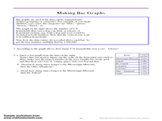
In this bar graph worksheet, students answer short answer questions about bar graphs. Students answer 1 question about a bar graph about a cat, and 3 questions about a bar graph about U.S. rivers.
Curated OER
Mapping Twentieth Century African-American Migration
Students develop their analytical skills when examining maps by comparing, contrasting, and sequencing information. They assess how geographical features such as the Appalachian Mountains and Mississippi River impacted settlement.
Curated OER
Mapping Twentieth Century African-American Migration
Young scholars study migration patterns of African-Americans. They assess how geographical features such as the Appalachian Mountains and Mississippi River impacted settlement and evaluate how modernized transportation affected the...
Curated OER
The Geography of the United States
Full of bright maps and interesting information, this presentation details U.S. Geography. Slides include basic facts about size, regions, topography, and demographics, as well as fascinating trivia about the United States, including...
K12 Reader
Water Carves the Land
What affect do bodies of water have on the world around us? Kids can find out by reading this passage. After reading, they answer five questions related to the text.
Curated OER
Zebra Mussels
In this zebra mussels instructional activity, 7th graders read an article about zebra mussel populations in United States' lakes and rivers. Students read about the negative effects and some positive results and then answer several...
Curated OER
Getting a Sense of Time
Young scholars gain an appreciation for geologic and historic time. They gain a general amount of information of the development of hte Chicago area, with particular attention given to the role of the Chicago River. Students contruct a...
Curated OER
Geography: How do Louisiana Rice Farmers Help the Environment after they Harvest Rice?
Third graders study maps of the United States locating Louisiana, the East Coastal Plain, the Mississippi Alluvial Plain, the West Gulf Coastal Plain, and five of the main rivers. In this geography activity, 3rd graders create a...
Curated OER
River Study
Students explore a stream in their area and show the class the topographic map of the stream. They locate the topographic map and name the streams, lakes and ponds in their watershed. They write a paragraph about their stream and...
Curated OER
Knock On Wood
Students investigate the trees of the Mississippi Valley, specifically looking at the coniferous and deciduous forests. The research of the area is part of a field study when students conduct a survey of local forests in order to create...
Smithsonian Institution
Eastern Indian Wars
Many know that Native Americans were forced off their lands and moved west, but how did these people react? The Red Sticks faction of the Creek nation opted to defend themselves and their lands in a series of wars called the Eastern...
Curated OER
The Hunter-Dunbar Expedition of 1804-1805
Students explain the origins of the Hunter-Dunbar Expedition and why it was so important. They map George Hunter and William Dunbar's expedition route on the Ouachita River and examine excerpts of George Hunter's journal.
Curated OER
Found Poem - Found Song, page 2
In this Louisiana musical landscape poem and song worksheet, students analyze a poem about the Mississippi River and Cajun music to learn more about the musical landscape in Louisiana.
Curated OER
How To Find a Site
Fourth graders identify the three basic needs of humans. They identify on a map the best places to live and make a list of items that they can find on a map - streams, river, hills, plains, forests, etc.
Curated OER
Katrina Case Study
Learners explore the impact natural events have on the environment, specifically the wetlands. They view a video about the impact of Hurricane Katrina on the Mississippi Delta and answer discussion questions.
Curated OER
Hide and Seek Science
Learners examine macro-invertebrates in order to better understand their link to the food web. Working in groups, they record observations of several areas of a stream or river, collect samples from the river bottom, and identify the...
Curated OER
On the Gulf: Coastlines in Danger
High schoolers study the Mississippi Rover and how it has changed over time. In this environment lesson students research and summarize things about the ecosystem of the river.
Curated OER
River Study
Students study physical features of a local stream. They study how to identify water features on topographic maps.
Curated OER
Arkansas Post was actually seven different French and Spanish forts that existed along the lower Arkansas River in
Eighth graders locate on a map the 3 geographic locations of the seven Arkansas Posts and explain the reason for each location move. They compare and contrast the reasons people move in today's world with the reasons the inhabitants of...
Curated OER
Mississippi Delta Blues Moves: Second in a Series of Three with Barb Hoffman and Steve Hoskins, MGM
Students complete a graphic organizer reviewing Barb Hoffman's prior lesson plan," Slave Songs (1840-1876)" as well as listen to and discuss Delta Blues music samples. Students research one Delta Blues singer and write a "color coded"...
Curated OER
The Colony of Virginia as Far as the Mississippi
Students study George Washington's map and journal of his 1754 expedition to the French. They draw conclusions about the importance of western lands and the problems involved in tapping the resources of the West during that era.
Curated OER
Black Hawk Island Hike
Students explore Wisconsin's natural and cultural history through hands-on exploration of Upham Woods. They are shown the basic paddling skills and they work in teams to paddle across the river on barge. Students describe cultural...
Curated OER
Where is the Water?
Students explore freshwater ecosystems. In this geography lesson, students brainstorm all the lakes and rivers they know then mark them on a map. Students will then mark all the major freshwater resources on each of the seven continents,...
Curated OER
Lewis and Clark Expedition
Ninth graders examine the goals of the Lewis and Clark Expedition and identify the present day cities, towns, rivers, and regions that are on the route of the expedition. They complete an online WebQuest, recreating the route of the...
Other popular searches
- Mississippi River Watershed
- Mississippi River Map
- Mississippi River Worksheet
- Geography Mississippi River
- Mississippi River Towns
- Ohio River Mississippi River
- Mississippi River Basin
- Mississippi River and Delta
- Mississippi River Management
- Mississippi River Wildlife
- Mississippi River Travel
- Mississippi River Valley


