Curated OER
A View from the Ground
Students look at a park from ground perspective. In this map skills lesson, students are introduced to a story about a girl at a park and make observations about the park based on a picture. This prepares students for the next lesson in...
Curated OER
Tortoise and Hare Races
Practice basic map skills with the story of The Tortoise and the Hare. After listening to the story, class members create a map that indicates the starting line, the path the animals took, where they stopped to rest, and the finish line....
Rainforest Alliance
Knowing the Essential Elements of a Habitat
To gain insight into the many different types of habitats, individuals must first get to know their own. Here, scholars explore their school environment, draw a map, compare and contrast their surroundings to larger ones. They then...
Tennessee State Museum
An Emancipation Proclamation Map Lesson
Did the Emancipation Proclamation free all slaves during the Civil War? Why was it written, and what were its immediate and long-term effects? After reading primary source materials, constructing political maps representing information...
Illustrative Mathematics
$20 Dot Map
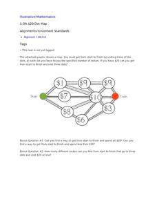
Challenge the addition skills of young learners with this open-ended math problem. The task is simple, get from start to finish by connecting a series of three numbers. The trick is that the sum of the numbers must be less than...
National Museum of the American Indian
The A:Shiwi (Zuni) People: A Study in Environment, Adaptation, and Agricultural Practices
Discover the connection of native peoples to their natural world, including cultural and agricultural practices, by studying the Zuni people of the American Southwest. This lesson includes examining a poster's photographs, reading...
K20 LEARN
Show and Tell Museum - Investigating Primary Sources: Read and Interpret Primary Sources
Scholars become detectives in a lesson that focuses on primary sources. Learners practice their observational skills by examining the teacher's artifact and visiting the Show and Tell Museum that highlihgts items from peers and...
Curated OER
Matthew Henson
Discuss the work of Matthew Henson, an African American who traveled to the North Pole with Robert Peary. After reading the story "Matthew Henson" by Maryann N. Weidt, learners answer questions by drawing inferences and conclusions,...
Curated OER
Elena by Diane Stanley
This story is bound to motivate your class. Learners read a story called Elena by Diane Stanley. The story is about a young woman who marries for love but is soon widowed during the Mexican Revolution. She takes her children to...
Curated OER
The Monkey's Paw
In this reading comprehension worksheet, students complete a variety of activities which demonstrate understanding of the book The Monkey's Paw .
Anti-Defamation League
Impact of the U.S. Expansion on Indigenous People and Stereotypes About Native American People
The 2004 U.S. bicentennial sparks a discussion about its meaning and importance to United States history. Readings, maps, tables, and reflective writing prompt small groups to explore the westward expansion, Lewis and Clark, and how...
Curated OER
Tortoise and Hare Races
Students listen to the fable, The Tortoise and the Hare, and participate in various map skill activities. They manipulate magnetic tortoises and hares on metal cookie sheets to practice direction, and construct racing tortoises out of...
Curated OER
Finding Your Way
Students work in small groups to practice basic map skills. They take turns giving directions and tracing a path from one location to different destinations on the map.
Curated OER
People Change the Landscape
Students examine ways in which humans have brought change to the natural environment. In this ecology and literacy lesson plan, students listen to the book Island Boy by Barbara Cooney. Students observe and define map-reading vocabulary...
Curated OER
2010 Census Lesson 1: It's About Us
Students analyze data from the 2000 census to learn how the census works. In this civics lesson, students read a story to find out about the census, then use a map and census data to analyze changes. Lesson includes related resources...
Curated OER
The Amazing Race
Students improve their directional awareness by locating sites and symbols on a map. They increase their heart rates while traveling to each site and performing the specified task/exercise at each site.
Curated OER
Johnny Appleseed Walkabout
Second graders calculate mileage for a journey. In this place value and measurement lesson, 2nd graders read Johnny Appleseed, work in groups to locate his birthplace on a map, locate the other states he stopped in, and measure the...
Curated OER
Reshaping the Nation
High schoolers learn why the census makes a difference. In this U.S. Census lesson plan, students learn how to read and use a cartogram while they explore new ways to represent data.
Curated OER
George Washington's Revolutionary Journeys
Students take a closer look at historical maps. For this American Revolution lesson, students examine the provided historical maps and documents to determine the assignments that George Washington assigned to subordinates during the...
Curated OER
Cacao Tree Geography
Students use a map to learn about where chocolate comes from. In this lesson on the cacao tree, students locate various regions where the cacao tree grows. They will discuss why the cacao tree grows more favorably in particular climates...
Curated OER
Charts, Maps, and Graphs Lesson on the Holocaust
Learners practice interpreting data. In this Holocaust lesson, students research selected Internet sources and examine charts, maps, and graphs regarding the Jewish populations in and out of Europe. Learners respond to questions about...
Curated OER
California Geography
Fourth graders explore geography of four distinct regions of California: mountains, coast, central valley, and desert. They locate California on map, identify state's boundaries and borders, and explore agriculture, a major economic...
Curated OER
Plotting a Hurricane Using Latitude and Longitude
Learners define and use "absolute location," latitude, and longitude. They locate on a map or globe the Earth's poles, circles, tropics, and beginning points of measurements for latitude and longitude.
Curated OER
The Globe and World Map
Students explore how to use maps for travel. In this map skills lesson, students read the text, With Love from Gran and discuss the places the character traveled. Students list the names of each city and country on chart paper.


