Curated OER
Using Primary Sources to Discover Reconstruction
Fifth graders discover how reconstruction had an impact on racial issues in the United States. In this Reconstruction lesson, 5th graders are introduced to primary vs. secondary resources and then rotate through stations to view...
Curated OER
Presidential Places
Students investigate American presidential landmarks throughout the continental United States. They research and analyze American presidential landmarks to determine their value to American history and how they have been preserved over...
Curated OER
Celebrate Kwanzaa in the United States
Students explore and study the celebration of Kwanzaa in which African-Americans remember their heritage and remind people of the importance of sharing with family and friends. They participate in a chant about the seven continents and...
Curated OER
An Introductory Lesson on Maps
Students identify what a map is. They draw their own map using a simplified overhead view. After hearing the book, "Nikk's Adventure," students create their own maps.
Curated OER
The United State of NATO
Students examine the past fifty years of NATO, focusing specifically on NATO's involvement and actions in conflicts around the world and the results of their involvement.
Curated OER
The Battle Over Reconstruction: The Aftermath of Reconstruction
Students examine the Reconstruction Era. In this American history activity, students explore the condition of the United States following the Civil War as they read statistical data. Students analyze the Reconstruction policies to...
Curated OER
Geography and Topography, History and Architecture
In this social studies lesson plan, students answer short answer questions about the geography, topography, history, and architecture of the east part of the United States. Students complete 24 questions.
Discovery Education
Architects in Action
Hands-on and real-world applications are great ways to teach mathematical concepts. Creative thinkers examine how ratios are used to create scale models of buildings and structures. They practice working with ratios by looking at a map...
Curated OER
Transporting Coal
Some really interesting worksheets on Amtrak's national routes, and the major river systems of the United States accompany this lesson on the transportation of coal throught the country. This is an exceptionally well-designed lesson that...
Curated OER
Effects of Urban Growth
Learners explore population growth in the United States and the impact it has had on society. First, they brainstorm the reasons for population growth and the results of these increases. Then, they design surveys, record results, and...
Curated OER
Holocaust Map Studies
Students analyze maps and answer discussion questions related to WWI. In this geography lesson, students analyze historic maps to determine causes and effects of WWI in Europe. Students read testimonies of Holocaust survivors and label...
Curated OER
Printable Map of Arkansas
In this printable map of Arkansas worksheet, students see a clip art picture of the state of Arkansas superimposed on the map of the United States. The see the capitol city, Little Rock, labeled on the map. There are no directions given...
Curated OER
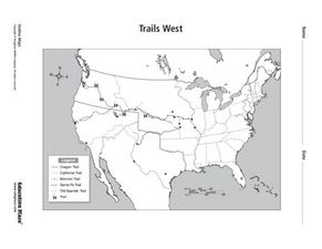
Trails West Map
In this United States historical map worksheet, students examine the trails that settlers of the Western United States took during the period of Western Expansion.
Curated OER
History Close to Home
Students examine primary sources as related to Nevada and the Civil War. In this United States history lesson, students gather and analyze various primary sources in small groups and interpret unknown vocabulary words by using context...
Curated OER
Colonial America 1776 Map
In this United States historical map learning exercise, students examine the colonial boundaries in 1776 as well as the Proclamation Line of 1763.
Curated OER
The 13 British Colonies Map
In this United States historical map worksheet, students examine the 13 colonial boundaries and noted major cities.
Curated OER
Ancient Greece and Ancient Rome Unit Plan
Students make two T charts, one for Sparta and one for Athens, showing pros and cons for living in either city-state. They use the physical information from the map and the cultural captions given for Athens and Sparts to come to their...
Teach Engineering
Where Are the Plastics Near Me? (Mapping the Data)
The last activity in a nine-part series has teams create a Google Earth map using the data they collected during a field trip. Using the map, groups analyze the results and make adjustments to the map to reflect their analysis. A short...
Curated OER
Making a Report to President Washington
Young scholars gain an understanding of some of the challenges the U.S. faced at its birth. They are asked to compose a report on the state of the nation in 1790 (addressed to President George Washington), which includes a narrative,...
Curated OER
Arkansas State Rock
Here is a lesson plan which shows the value of a mineral called bauxite to Arkansas during the early 1900's. Learners relate the five themes of geography to the history of bauxite and aluminum production in Arkansas. For teachers of...
Curated OER
Map-A-Buddy
Learners investigate the concept of tracking and spatial movements of animals in relation to the environment in which they live. They participate in an interactive activity by tracking one another over a pre-defined region, record the...
Curated OER
Let the Music Play: Bicentennial quarter reverse
To better understand who George Washington was and why we celebrated the bicentennial, pupils read a story and complete a worksheet. They sing and talk about the song, "Yankee Doodle Dandy" as they march around the room.
Annenberg Foundation
A Nation Divided
Can a presidential election cause a civil war? Learners research the events surrounding the presidential election of 1860 in a lesson that explores America's history. Using maps, videos, and primary sources, they uncover, brainstorm, and...
Theodore Roosevelt Association
Roosevelt's Legacy: Conservation
The legacy of Theodore Roosevelt carries through modern American politics, economics, foreign policy, and society. But his proudest and most profound efforts were in the world of conservation, and in preserving the natural beauty of...
Other popular searches
- United States Maps Regions
- Northeast United States Maps
- 50 United States Maps
- Create United States Maps
- Western United States Maps
- Custom United States Maps
- Outline Maps United States
- Blank United States Maps
- Maps, United States Rivers
- Maps United States Capitals
- Maps of the United States
- Maps United States


