Curated OER
The Brief American Pageant: The South and the Slavery Controversy
The unseemly world of American slavery is on display in these slides, which include informational images about slavery in the South. From maps about cotton production to graphs about slave-owning families, these images will make a...
Curated OER
1792 Election Results
The beginning of American politics and elections is found in these slides, which detail the 1792, 1796, 1800 elections of Washington, Adams, and Jefferson (respectively). Plan on including your own discussion points and details in this...
Curated OER
The Election of 1840
Entertaining political cartoons, campaign songs, and slogans are sprinkled throughout this presentation, which details the Presidential Election of 1840. Teachers can bring their own discussion topics to the slideshow with references to...
Curated OER
The European Conquest of the Americas
Witness the birth of the Americas in this presentation, which details the European Explorers who contributed to adding vital details on our modern-day maps. Viewers' worlds will literally expand after seeing the results of Cortes and the...
Curated OER
The Brief American Pageant: America on the World Stage
America's presence in Alaska and the Caribbean are the focus of this short presentation. Two detailed maps help to illustrate America's growing influence in the regions past its continental borders, which could supplement a more thorough...
Curated OER
The Constitution: A New Federation
Students explore political parties by researching world history in class. In this Australian government lesson, students identify the term "federation" and discuss the elements of Australian politics. Students analyze a map of Australia...
Curated OER
The Distribution of Woodland in the United States, 1873
Students investigate a map of 1873 that shows woodland in the United States. They examine this map to explore the different ways trees have been used in the United States and predict how the way we use woodlands today could affect them...
Curated OER
Children in the United States and Japan
Young scholars locate Japan on a map or globe and describe the relative location of Japan. They use the Internet to investigate cultural characteristics of children in the United States and in Japan. They use a Venn Diagram as an...
Curated OER
Cardinal Directions
First graders study cardinal directions on maps. In this geography lesson, 1st graders determine and show where North, South, East, and West are on various maps.
Curated OER
Mexico: One Land, Many Cultures
Students, through a variety of activities, discover the geography and culture of Mexico. They make maps, read folktales, write a journal, create pinatas and other artistic pieces, and review the history of Mexico.
Curated OER
Where in the Latitude Are You? A Longitude Here.
Students distinguish between latitude and longitude on the map. In this mapping lesson, students participate in mapping skills to recognize spatial relationships, and where to find natural resources on the map. Students create their own...
Curated OER
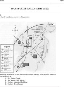
Fourth Grade Social Studies
In this social studies worksheet, 4th graders answer multiple choice questions on state maps, city maps, road maps, political maps, and more. Students complete 25 multiple choice questions.
Curated OER
California Geography
Fourth graders explore geography of four distinct regions of California: mountains, coast, central valley, and desert. They locate California on map, identify state's boundaries and borders, and explore agriculture, a major economic...
Curated OER
Indiana Travel Guide
Fourth graders share their information about their home state. In this research lesson plan, 4th graders use graphic organizers to make a travel guide about the state of Indiana. This lesson plan could be modified for use with any state,...
Curated OER
5th grade social studies geography
For this geography worksheet, 5th graders complete multiple choice questions about hemispheres, maps, cities, ecology, and more. Students complete 25 questions.
Curated OER
2010 Census Lesson 1: It's About Us
Learners analyze data from the 2000 census to learn how the census works. In this civics lesson, students read a story to find out about the census, then use a map and census data to analyze changes. Lesson includes related resources...
Curated OER
Geography Puzzles
Students study the continents of the world. In this Internet geography instructional activity, students connect to online mapping games. Students collaborate in order to develop their understanding of world geography, including countries...
Curated OER
Who Wants to Be a Millionaire in the U.S.A.?
Students research the states, gathering information and creating questions and answers. They play a form of Who Wants to be a Millionaire? using the student-generated questions and answers.
Curated OER
Our World With MapsQ
Learners examine and compare different types of maps. In this map skill lesson, students look at neighborhood and national maps on the overhead projector while making comparisons of the symbols and locations. They use a T-chart to record...
Curated OER
Memories from the National Sites
Students write a virtual postcard. In this logo activity students are introduced to the concept of postcard writing. Students research the national sites and states highlighted on quarters for that year. Students take a virtual trip to...
Curated OER
North American Biomes
In this Science worksheet, learners color a biome map of North America. Students color the map by solving the clues listed on a separate sheet of paper.
Curated OER
It's Time to Rhyme
Learners listen to rhyming book, identify rhyming pairs, guess what rhyme words mean, and create list of rhyming pairs on chart paper. They then discuss Fifty States Quarters Program, identify objects on backs of state coins, and...
Curated OER
Weather Prediction
In this weather worksheet, students are given a map of the United States and they analyze the map and answer questions about the weather in different cities.
Curated OER
Lewis and Clark
Fifth graders use the Internet to research a topic. In this expeditions lesson, 5th graders answer questions about Lewis and Clark based on the movie they watched previously, use the Internet to research Lewis and Clark, write a journal...
Other popular searches
- United States Maps Regions
- Northeast United States Maps
- 50 United States Maps
- Create United States Maps
- Western United States Maps
- Custom United States Maps
- Outline Maps United States
- Blank United States Maps
- Maps, United States Rivers
- Maps United States Capitals
- Maps of the United States
- Maps United States


