Stanford University
Sheg: Document Based History: Reading Like a Historian:examining Passenger Lists
[Free Registration/Login Required] Students use primary source documents to investigate central historical questions. In this investigation, students critically examine the passenger lists of ships headed to New England and Virginia to...
Huntington Library
Huntington Library: Religious Dissent [Pdf]
This activity supplements one on the "Settlement of the Plymouth and Massachusetts Bay Colonies of New England." It looks at religious dissent and intolerance among the Puritans in the Massachusetts Bay Colony. Students look at Roger...
Huntington Library
Huntington Library: Settlement of the Plymouth and Massachusetts Bay Colonies
In this lesson, 5th graders learn about the people who founded the New England colonies and the role that religion played in shaping them. Includes background information for the teacher. Students explore primary resource readings on the...
Syracuse University
Syracuse University: Map of New England, 17th Century
A map that shows the seventeenth-century migration routes of the Puritans from England to New England. Early population centers are designated as well as some interregional migrations.
New York Times
New York Times: While England Sinks: Witch of Exmoor by Margaret Drabble
[Free Registration/Login Required] Drabble does not come out well in this "New York Times" review. The critic's comments on Drabble's characters and discussion of the influence of Virginia Woolf and Charles Dickens provide insight into...
Library of Congress
Loc: Portuguese in the u.s.: Whaling, Fishing, and Industrial Employment
This brief article outlines the the employement of Portuguese immigrants in the whaling industry in southern New England in the 19th century.
Other
Old Sturbridge Village: Explore and Learn
Sturbridge Village, a preserved New England mill town, can give the student glimpses back to late 18th, early 19th century life. Be sure to click on Learn About the Past, and Ask Jack.
Bartleby
Bartleby.com: Cambridge History of Eng and Am Lit: Beginning of Verse, 1610 1808
Discussion of the earliest poetry in Colonial New England. Describes common themes and forms and identifies specific poets of the period.
Independence Hall Association
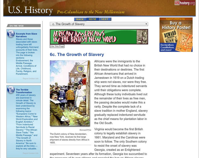
U.s. History: African Americans in the British New World: The Growth of Slavery
Africans first arrived in Jamestown as indentured servants, but soon the appeal of having laborers that were not free after seven years caught on. See how the use of slaves grew in the Southern colonies, the economies of which were based...
Other
Fortress of Louisbourg National Historic Park
The fortress of Louisbourg was one of the pivotal centre's of control and defense in the colony of New France. Ultimately, whomever controlled Louisbourg controlled access to the St. Lawrence Seaways and access to the New France...
Curated OER
Educational Technology Clearinghouse: Maps Etc: New England Grants, 1643 1684
A map of the Massachusetts Bay Colony and New England Confederation (1643-1684) showing the grants of the area, and is keyed to show: (1) the Plymouth Colony (1620), (2) Massachusetts, (3) Massachusetts Bay, (4) Maine, (5) New Hampshire,...
Curated OER
Etc: New England Colonies, 1620 1638
A map of the New England colonies showing the early permanent Pilgrim settlements and their dates of establishment, including Plymouth (1620), Little Harbor, New Hampshire (1623), Pemaquid, Maine (1625), Salem, Massachusetts (1628),...
Curated OER
Etc: The Revolution in New England States, 1774 1783
A map of America's New England states during the time of the American Revolution, including Maine, New Hampshire (with Vermont), Massachusetts, Rhode Island, Connecticut, and Long Island. The map shows major cities, towns, forts, battle...
Curated OER
Etc: New England Colonies, 1620 1641
A map of the New England Colonies showing the westward expansion of the Pilgrims from Plymouth (1620) to Stamford, Connecticut (1641). The map shows settlements in the area with dates of establishment given, colony boundaries, New...
Curated OER
Etc: The Chief Settlements Made in New England, 1620 1675
A map of the New England region showing the chief early European settlements between 1620-1675. The map shows rivers, terrain and coastal features, the coastal settlements of Pemaquid, Saco, Dover, Portsmouth, Salem, Cambridge,...
Curated OER
Educational Technology Clearinghouse: Maps Etc: New England, 1631
A facsimile of an early map of New England in 1631 as observed by Captain John Smith in 1614. The map covers the coastline from Cape James (Cape Cod) and Stuards Bay (Cape Cod Bay) north to Pembrocks Bay and the Bay of Fundy. A...
Curated OER
Educational Technology Clearinghouse: Maps Etc: New England, 1680
North Atlantic coast of the New England region.
Curated OER
Etc: Maps Etc: Northern New England and Canada, 1919
The Northern New England states and part of Canada in 1919, showing roads.
Curated OER
Etc: Maps Etc: Texas and the New England States, 1916
A comparison of sizes between Texas and the New England states.
Curated OER
Clip Art by Phillip Martin: New England States
A clipart illustration by Phillip Martin titled "New England States."
Independence Hall Association
U.s. History: New England Colonies: The Mayflower and Plymouth Colony
Read a brief description of the Pilgrims' journey to North America. Find out how many travelers on the Mayflower were actually Pilgrims, and find out why a mistake in navigation led to the first written constitution in the New World.
Other popular searches
- New England Colonies
- Colonial New England
- New England Economy
- Early Settlers. New England
- Family History New England
- New England Colonies Map
- New England States
- The New England Colonies
- Map of New England
- New England Bird Migration
- Northern New England
- New England Region


![Huntington Library: Religious Dissent [Pdf] Lesson Plan Huntington Library: Religious Dissent [Pdf] Lesson Plan](https://d15y2dacu3jp90.cloudfront.net/images/attachment_defaults/resource/large/FPO-knovation.png)


